To understand the full benefits of EMODnet, users are kindly asked to describe how EMODnet supports them in their daily work and activities.
If you have developed an application using EMODnet products that you would like to share with us or if you use EMODnet data for other purposes, submit your use case by contacting secretariat@emodnet.ec.europa.eu.
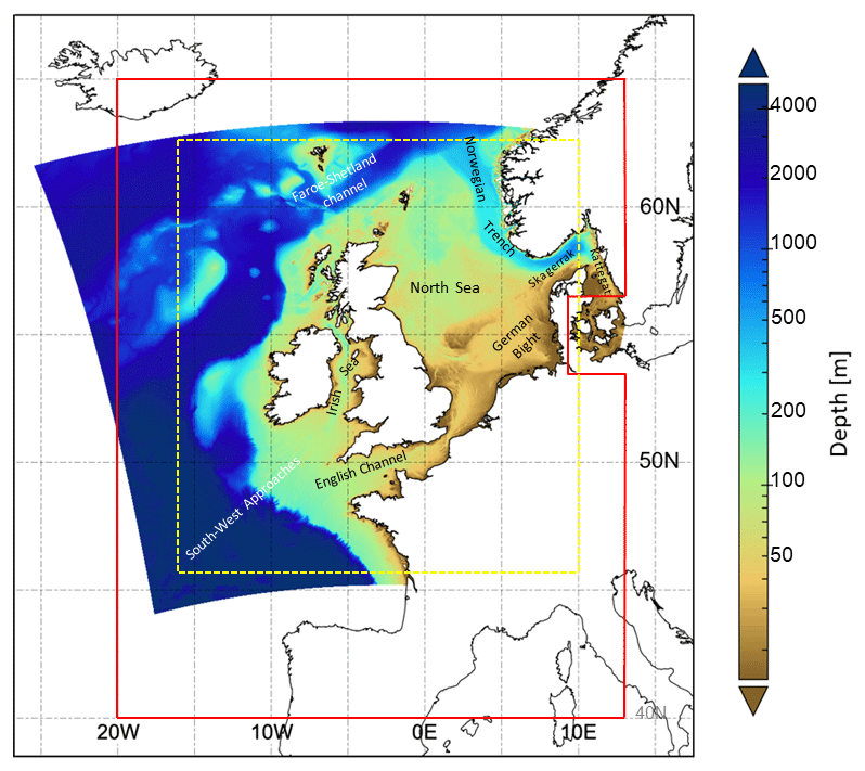
The Met Office provides forecasts of the ocean properties for the European North West Shelf through the Copernicus - Marine Environment Monitoring Service. In 2018, the forecast resolution was upgraded from ~7 to ~1.5 km. Validation at the basin scale and using typical metrics with daily means penalises the high-resolution system and does not reflect the superior performance of the high-resolution system. High resolution observations in selected areas of the model domain were crucial to demonstrate the improvement of the finer resolution model.
The digital topographic map layers produced by EMODnet do not only show the depth of water, they also indicate where surveys are sparse and confidence in data is low. Extending this analysis for more distant waters requires collaboration with countries outside the EU who have similar programmes.
JNCC produced a ‘Combined Map’ integrating data from field survey maps (mostly from the EUNIS habitat datasets collection) and the most recent version of the EMODnet Seabed Habitats broad-scale predictive habitat map available at that time. The Combined Map is a single flat layer without overlaps between habitats or component datasets, making it suitable and efficient for area calculations.
The European contribution to the Ocean Biogeographic Information System (OBIS) is significant with EMODnet playing a pivotal role: around 20 million of these records are provided by EMODnet Biology.
The EMODnet Chemistry portal has tested the application of INSPIRE Data Specifications to model nutrient data (MSFD Criterion D5C1 “Nutrients concentrations in water”) in the Mediterranean Sea. The use case builds on the Technical Guidelines related to Environmental Monitoring Facilities (EMF) and Oceanographic Geographical Features (OF) themes and to the Observations and Measurement (O&M) data model and was developed in collaboration with the SeaDataCloud and MEDCIS projects. The exercise demonstrated the completeness of EMODnet Chemistry metadata with respect to INSPIRE requirements and the feasibility to map EMODnet to INSPIRE models.
Undertaking a regional cumulative impact assessment requires a vast amount of spatial data. EUSeaMap v2016 was a key data source for defining ecosystem components in reporting on the 2011-2016 HELCOM ‘State of the Baltic Sea’.
It is not an easy task for a met-ocean data user to clearly understand which data have been used in the calibration / validation phase of the hindcast database, the use of EMODnet Physics as the main source for observed marine data collection is highlighted in the description of the DHI’s MWM product.
The availability of both depth data and geology data from one centralised point of contact (EMODnet) enabled Irwin Carr Consulting, an SME that provides specialist services that range from environmental noise, air quality, building acoustics and underwater noise, to be competitive and have efficient turn-around times on marine projects that otherwise would be delayed by prohibitively costly marine mapping work prior to impact assessments.
The development of EMODnet standard classifications for the various categories of seabed substrate allowed a digital map layer covering Russian, Finnish and Estonian waters to contribute towards the Gulf of Finland assessment published in 2016. This was one of the most important outcomes of the Gulf of Finland Year arranged by the three countries in 2014.
Now the approach would be to use ICES and EMODnet Chemistry to provide a comprehensive European data source for the European Environment Agency Marine Indicators on contaminants (Biota) and Eutrophication (Chla, Nutrients) and a pipeline on oxygen saturation.