To understand the full benefits of EMODnet, users are kindly asked to describe how EMODnet supports them in their daily work and activities.
If you have developed an application using EMODnet products that you would like to share with us or if you use EMODnet data for other purposes, submit your use case by contacting secretariat@emodnet.ec.europa.eu.
Outcomes:. Authors were able to identify that differences in diet of grey seals (Halichoerus grypus) reflect regional differences in physical habitat features.
How EMODnet Seabed Habitats helped the user:Sediment and depth data were derived utilising output of the EUSeaMap 2016.
Outcomes: The ETC/ICM found Aichi target 11 was met for all European MPAs protecting infralittoral regions, mostly met for MPAs protecting circalittoral and bathyal regions, but were completely missed for MPas protecting abyssal zones.
How EMODnet Seabed Habitats helped the user: Provided the only source of evidence for Distribution of broad habitats and biozone distribution at pan European scale.
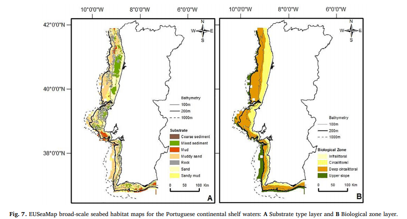
Outcomes: The author was able to identify four regions of ecological significance along the Portuguese coast and assess the level of protection offered by Natura 2000 SPAs and SCIs. One of the hotspots was found to be only partially covered by the Natura 2000 sites, suggesting more quantitative-based approaches should be applied to assist management plans in safeguarding local biological value.
How EMODnet Seabed Habitats helped the user:EUSeaMap provided broad-scale seabed habitat maps and biozones for the study area.
Outcomes: Authors present a framework to assess the impacts of mobile fishing gear on the seabed and benthic ecosystems, the principles of which are applicable to all benthic habitats and trawl fisheries, and can be used across a wide range of spatial scales.
How EMODnet Seabed Habitats helped the user:EMODnet provided EUNIS Level 3 habitat maps across European waters.
Outcomes:Authors used an Ecological Niche Model to identify previously overlooked areas of the Mediterranean and Eastern Atlantic, as areas containing soft coral habitats. The model could then be used for future surveys to target areas predicting presence of coral habitats and identify new priority conservation areas.
How EMODnet Seabed Habitats helped the user:EUSeaMap provided information on the distribution of rocky bottomed habitats across the study area.
Outcomes: Authors present a framework to assess the impacts of mobile fishing gear on the seabed and benthic ecosystems, the principles of which are applicable to all benthic habitats and trawl fisheries, and can be used across a wide range of spatial scales.
How EMODnet Seabed Habitats helped the user:EMODnet provided EUNIS Level 3 habitat maps across European waters.
Outcomes: Authors were able to propose methods for assessing representativity across European MPA's, suggesting the use of biozones and benthic habitats within EUSeaMap as a primary data source. Moreover, assessment habitat classes (revised broad habitats) are proposed based on the crosswalk of MSFD broad habitat types with respect to EMODnet Folk 5 substrate and seabed biological zone classes
Authors identified that boundaries of successful no-take MPAs may still be zones of high stress for habitat forming species such as maerl. Additionally, authors suggested that MPA designations should re-consider boundaries in areas with low-resilience, key-forming habitat species.
This study was published by authors from a range of universities and research institutes. The lead author is a representative of the Department of Biology of Universidade de Aveiro, a Portuguese university.