 EMODnet product catalogue
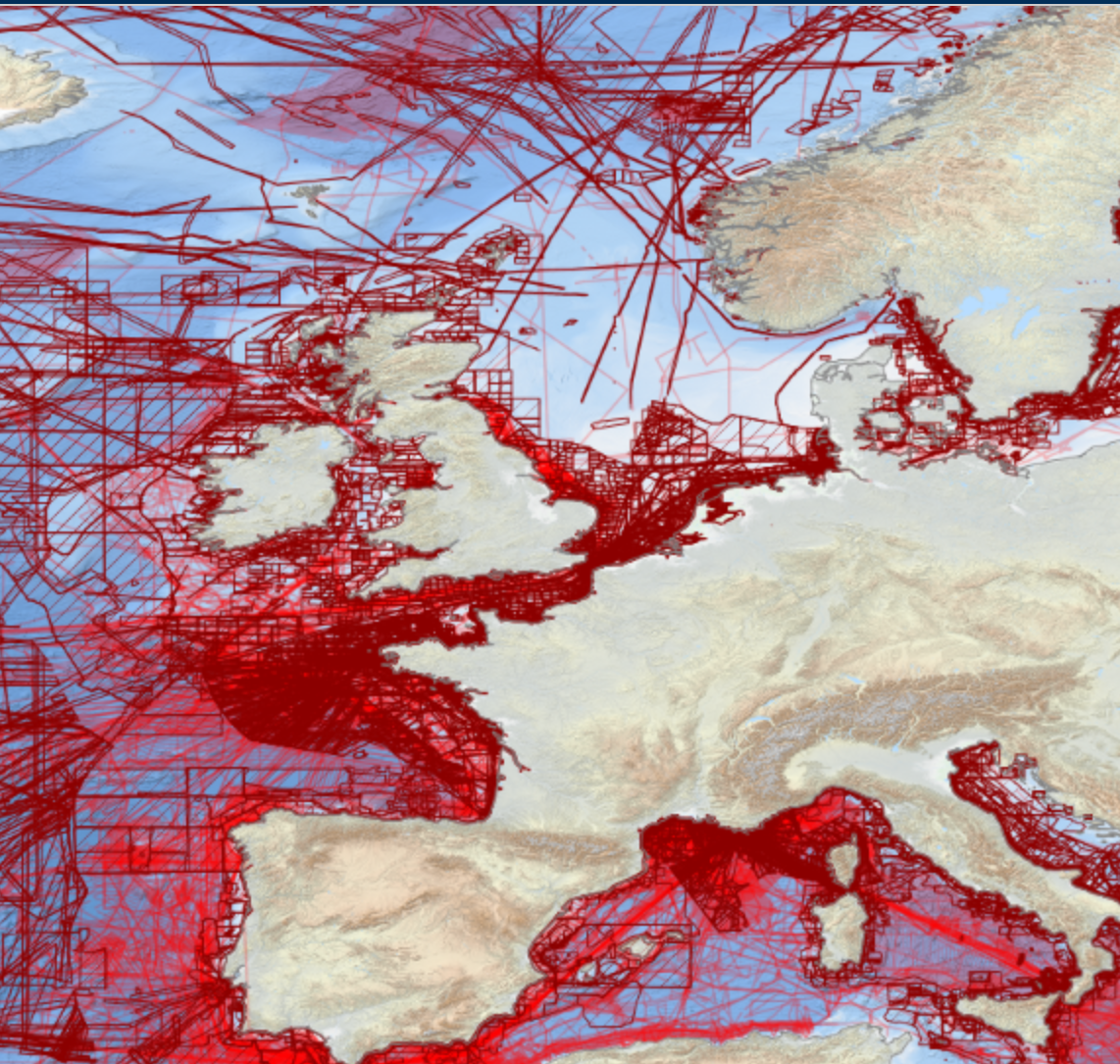
EMODnet Bathymetric Surveys
EMODnet Bathymetry has adopted the CDI Data Discovery & Access service as developed and operated by SeaDataNet, the pan-European network of NODCs, to bring together and provide access to available high resolution bathymetric survey data sets from many data providers, such as National Hydrographic Institutes, Research Institutes, and Survey companies.
All bathymetric survey data are described with INSPIRE compliant metadata, following the CDI metadata profile, based on ISO 19115 – 19139 standards. This way, the CDI service gives users a highly detailed insight in the availability and geographical spreading of bathymetric survey data sets that are acquired and managed by an increasing group of data providers and for which users can request access for downloading. The CDI metadata are public domain and freely available for all users. However, a major part of the survey data sets is not freely available and requires negotiation with the data owners. The SeaDataNet CDI search, shopping and tracking mechanism facilitates identifying and requesting access to these background data sets from data providers. Note that all data sets are used internally with permission of the data owners for contributing to the EMODnet Digital Terrain Model (DTM) for the European sea regions.
The service URL is : https://geo-service.maris.nl/emodnet_bathymetry/wfs?service=WFS&request=GetCapabilities.
The layer in the Map Viewer facilitates users to view the locations of the CDI entries and to retrieve details of individual surveys by clicking on the map. From there users are linked to the actual CDI Data Discovery and Access service ( https://cdi-bathymetry.seadatanet.org/search) for performing more queries and submitting requests for data access.
Simple
- Date (Publication)
- Citation identifier
- EMODnet_BAthy_Surveys
- Point of contact
-
Organisation name Individual name Electronic mail address Role EMODnet Bathymetry Consortium
Point of contact
- Access constraints
- Creative Commons Attribution 4.0 International
- Use constraints
- Other restrictions
- Other constraints
-
DO NOT USE FOR NAVIGATION
- Spatial representation type
- Vector
- Language
- English
- Character set
- UTF8
- Topic category
-
- Oceans
))
- Distribution format
-
Name Version
- OnLine resource
-
Protocol Linkage Name WWW:LINK
https://tiles.emodnet-bathymetry.eu/ EMODnet Bathymetry WMTS service
WWW:LINK
https://emodnet.ec.europa.eu/geoviewer EMODnet viewer
- Hierarchy level
- Dataset
Domain consistency
Conformance result
- Title
-
RÈGLEMENT (UE) N o 1089/2010 DE LA COMMISSION du 23 novembre 2010 portant modalités d'application de la directive 2007/2/CE du Parlement européen et du Conseil en ce qui concerne l'interopérabilité des séries et des services de données géographiques
- Date (Publication)
- 2010-12-08
- Explanation
-
See the referenced specification
Metadata
- File identifier
- 30eb6e4f-bc30-44fd-8cc7-a2763de64791 XML
- Metadata language
- English
- Character set
- UTF8
- Hierarchy level
- Dataset
- Date stamp
- 2025-05-15T21:53:36.508728Z
- Metadata standard name
-
ISO 19115-3 - SEXTANT
- Metadata standard version
-
1.0
)))
