 EMODnet product catalogue
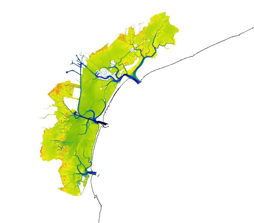
1528 HRDTM 1/128 IB_Venice_lagoon_2022
Satellite-derived bathymetry for the Venice Lagoon
Simple
- Date (Creation)
- Date (Revision)
- Citation identifier
- Venice_lagoon_IB_128
- Point of contact
-
Organisation name Individual name Electronic mail address Role Deltares
Originator Deltares
Custodian
-
Project name
-
-
EMODnet HRSM
-
-
SeaDataNet device categories
-
-
single-beam echosounders
-
multi-beam echosounders
-
-
Parameter Discovery Vocabulary (P02)
-
-
Bathymetry and Elevation
-
-
GEMET - INSPIRE themes, version 1.0
-
-
Hydrography
-
- Access constraints
- Creative Commons Attribution 4.0 International
- Use constraints
- Other restrictions
- Other constraints
-
DO NOT USE FOR NAVIGATION
- Spatial representation type
- Grid
- Distance
- 0.0078125 Arc minute
- Language
- English
- Character set
- UTF8
- Topic category
-
- Oceans
))
- Description
-
Map projection parameters, values and units :
Axes units :
- Codespace
-
EPSG
- Version
-
7.4
- Reference system identifier
- EPSG / WGS 84 (EPSG:4326) / 7.4
- Number of dimensions
- 3
- Dimension name
- Column
- Dimension name
- Row
- Dimension name
- Time
- Dimension size
- 1
- Cell geometry
- Point
- Transformation parameter availability
- No
- Checkpoint Availability
- No
- Point in Pixel
-
- Center
- Distribution format
-
Name Version
- Distributor contact
-
Organisation name Individual name Electronic mail address Role Deltares
Distributor
- OnLine resource
-
Protocol Linkage Name WWW:LINK
WWW:LINK
https://tiles.emodnet-bathymetry.eu/ EMODnet Bathymetry WMTS service
WWW:LINK
https://emodnet.ec.europa.eu/geoviewer/ EMODnet viewer
WWW:DOWNLOAD
https://downloads.emodnet-bathymetry.eu/high_resolution/1528_Venice_lagoon_IB_128.emo.zip
- Hierarchy level
- Dataset
Vertical extent
- Minimum value
- 1.922
- Maximum value
- 47.748
Vertical CS
Vertical datum
- Statement
-
no information
- Hierarchy level
- Feature
- Dataset
-
accuracy
Gridded data positional accuracy
- Name of measure
-
horizontal accuracy
- Measure identification
- horizontal accuracy of coordinate
- Measure description
-
20 meters
- Evaluation method description
-
Rough estimate
Quantitative result
- Value type
- horizontal accuracy
Quantitative attribute accuracy
- Name of measure
-
depth
- Measure identification
- depth accuracy
- Measure description
-
20 cm
- Evaluation method description
-
Rough estimate
Quantitative result
- Value
- not defined
Conformance result
- Title
-
Shoal bias
- Date
- Hierarchy level
- Software
- Other
-
software
- Hierarchy level
- Property type
- Description
-
parameters of data processing
Attributes
- Statement
-
Water-occurrence from many satellite images combined with water height frequencies from the model.
- Description
-
Combination of optical satellite and a water-levels computed with a numerical model
- Hierarchy level
- Dataset
Absolute external positional accuracy
- Name of measure
-
emodnet-bathymetry.QI.Horizontal
- Value
- 2 - Between 50 m and 20 m
Absolute external positional accuracy
- Name of measure
-
emodnet-bathymetry.QI.Vertical
- Value
- -1 - Multisources
Domain consistency
- Name of measure
-
emodnet-bathymetry.QI.Purpose
- Value
- 1 - Transit and/or opportunity
Metadata
- File identifier
- SDN_CPRD_1528_Venice_lagoon_IB_128 XML
- Metadata language
- English
- Character set
- UTF8
- Hierarchy level name
-
Product record
- Date stamp
- 2023-05-05T13:27:17.18Z
- Metadata standard name
-
ISO 19115:2003/19139 - EMODNET - BATHYMETRY
- Metadata standard version
-
1.0
- Metadata author
-
Organisation name Individual name Electronic mail address Role Deltares
Author
)))
