 EMODnet product catalogue
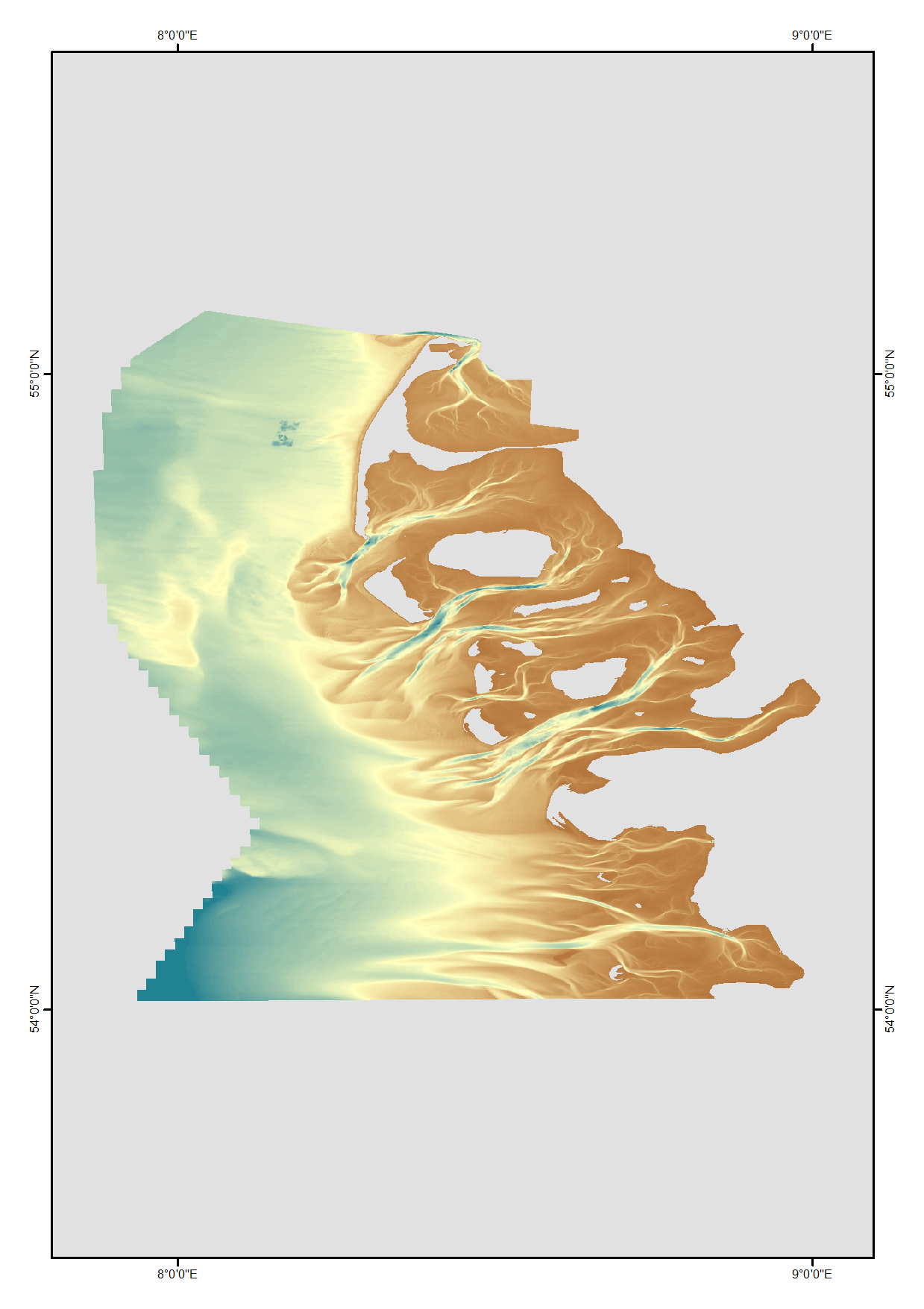
HRDTM 1/512 Schleswig-Holstein
High resolution digital terrain model of the North Frisian waters based on survey data from various sources such as single-beam, multi-beam and Lidar.
Simple
- Alternate title
-
UAEms_2015
- Date (Creation)
- Date (Revision)
- Citation identifier
- SH_2012
- Point of contact
-
Organisation name Individual name Electronic mail address Role Federal Maritime and Hydrographic Agency
Originator Federal Maritime and Hydrographic Agency
Custodian
-
Project name
-
-
EMODnet HRSM
-
-
SeaDataNet device categories
-
-
single-beam echosounders
-
multi-beam echosounders
-
-
SeaDataNet device categories
-
-
Differential Global Positioning System receivers
-
-
Parameter Discovery Vocabulary (P02)
-
-
Bathymetry and Elevation
-
-
GEMET - INSPIRE themes, version 1.0
-
-
Hydrography
-
- Access constraints
- Creative Commons Attribution 4.0 International
- Use constraints
- Other restrictions
- Other constraints
-
DO NOT USE FOR NAVIGATION
- Spatial representation type
- Grid
- Denominator
- 5000
- Distance
- 0.00195313 Arc minute
- Language
- English
- Character set
- UTF8
- Topic category
-
- Oceans
- Begin date
- 1990-01-01
- End date
- 2012-12-31 Before
))
- Geographic identifier
- North Sea
- Description
-
Map projection parameters, values and units :
Axes units :
- Codespace
-
EPSG
- Version
-
7.4
- Reference system identifier
- EPSG / ETRS89 (EPSG:4258) / ETRS89-UTM32 (EPSG:25832)
- Number of dimensions
- 3
- Dimension name
- Column
- Dimension size
- 36109
- Dimension name
- Row
- Dimension size
- 33483
- Dimension name
- Time
- Dimension size
- 1
- Cell geometry
- Point
- Transformation parameter availability
- No
- Checkpoint Availability
- No
- Point in Pixel
-
- Center
- Distribution format
-
Name Version ASCII grid / ESRI grid
1.0
- Distributor contact
-
Organisation name Individual name Electronic mail address Role EDMO name
Distributor
- Distributor contact
-
Organisation name Individual name Electronic mail address Role Federal Maritime and Hydrographic Agency
Distributor
- Transfer size
- 58000
- OnLine resource
-
Protocol Linkage Name WWW:LINK
http://www.bsh.de WWW:LINK
https://emodnet.ec.europa.eu/geoviewer EMODnet viewer
WWW:LINK
https://tiles.emodnet-bathymetry.eu/ EMODnet Bathymetry WMTS service
- OnLine resource
- Hierarchy level
- Dataset
Vertical extent
- Minimum value
- 0
- Maximum value
- 37.5
Vertical CS
Vertical datum
- Statement
-
no information
- Hierarchy level
- Feature
- Dataset
-
accuracy
Gridded data positional accuracy
- Name of measure
-
horizontal accuracy
- Measure identification
- horizontal accuracy of coordinate
- Measure description
-
1.0
Quantitative result
- Value type
- horizontal accuracy
Quantitative attribute accuracy
- Name of measure
-
depth
- Measure identification
- depth accuracy
- Measure description
-
0.4
Quantitative result
- Value
- not defined
Conformance result
- Title
-
Shoal bias
- Date
- Hierarchy level
- Software
- Other
-
software
- Hierarchy level
- Property type
- Description
-
parameters of data processing
Attributes
- Statement
-
Description of data processing :
- Description
-
Description of processed data sources : SDN:CPRD:1850_SH_2012
- Hierarchy level
- Dataset
Absolute external positional accuracy
- Name of measure
-
emodnet-bathymetry.QI.Horizontal
- Value
- 3 - < 20 m
Absolute external positional accuracy
- Name of measure
-
emodnet-bathymetry.QI.Vertical
- Value
- 3 - Lidar, SBES high frequency
Domain consistency
- Name of measure
-
emodnet-bathymetry.QI.Purpose
- Value
- 3 - Hydrographic survey or compatible with hydrographic standards
Metadata
- File identifier
- SDN_CPRD_1850_SH_2012 XML
- Metadata language
- English
- Character set
- UTF8
- Hierarchy level name
-
Product record
- Date stamp
- 2022-09-21T09:04:45.872Z
- Metadata standard name
-
ISO 19115:2003/19139 - EMODNET - BATHYMETRY
- Metadata standard version
-
1.0
- Metadata author
-
Organisation name Individual name Electronic mail address Role Federal Maritime and Hydrographic Agency
Author
)))
