 EMODnet Product Catalogue
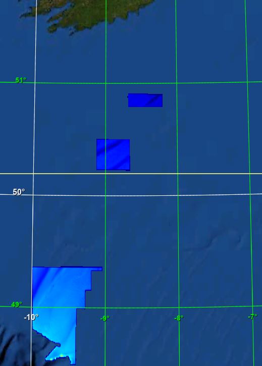
BY_CelticExplorer_CelticSea_14m_WGS84
Description of measurements/samples, purpose for which they were collected, and the platforms/instrumentation and methods in collection RV Celtic Explorer 2019 Leg 1 Celtic Sea North Cork 14m Globe DTM WGS 1984 projection Lowest Astronomical Tide (LAT). The GSI has been permitted to utilise the UKHO VORF (Vertical Offshore Reference Frame) sea surface model. This model allows the use of ‘GPS tides’ and the GSI has gridded this model to a 1km resolution around Ireland to 15km offshore for reducing all soundings to Lowest Astronomical Tide - LAT (VORF). By utilising ‘GPS tides’ there is no requirement to adjust for draft or squat as the water level is modelled over the seabed as measured to the WGS84 ellipsoid. This area was surveyed as part of the ongoing INFOMAR project (formerly Irish National Seabed Survey), a joint seabed mapping project between the Geological Survey Ireland and the Marine Institute. Survey work was conducted to standards and recommendations set out by INFOMAR, the International Hydrographic Organisation (IHO), the United Kingdom Hydrographic Office (UKHO) and the UK’s Maritime and Coastguard Agency (MCA). Please note the following: Data acquired prior to March 2011 were levelled to Lowest Astronomical Tide (LAT) using shifts derived from Proudman Oceanographic tidal model. Tidal height was derived using a network of offshore and onshore tide gauges. As such data are on average 0.54m deeper than the more recent UKHO Vertical Offshore Reference Frame (VORF) levelled data. We are currently updating the older datasets. Statement on the level of data processed and quality control, limitations on reliability INFOMAR bathymetry products generated to meet International Hydrographic Organization (IHO) standards to ensure gridded data positional accuracy in the horizontal (XY) and vertical (Z) frame. Arrangement of data Data has been processed and arranged into a GLOBE DTM grid using XYZ data. Spatial and temporal resolution of data within the dataset Image resolution is a 14m DTM grid. Length of time series Image created from data collected between 2019-09-21 and 2019-10-08 Amount of data expressed in number of stations, sites, observations, cores, months of recordings, miles of track or other units as appropriate Bathymetry image meets GLOBE DTM standard. Data provided under Creative Commons licence access and use conditions. Users of this data should provide the following attribution statement “Contains Irish Public Sector Data (Geological Survey Ireland; Marine Institute) licensed under a Creative Commons Attribution 4.0 International (CC BY 4.0) licence”
owner : {{md.getOwnername()}}
{{'mdStatusRecord' | translate}}: {{('mdStatus-' + md.mdStatus) | translate}}
- Identification
- Content
- ReferenceSystem
- Quality
- DomainConsistancy
- Constraints
- Distribution
- Meta-metadata
- ObjectCatalogue
| Alternate title | KN172L08 SeaBeam 3012-P1 Bathymetry Grid |
|---|---|
| Date | 2021-12-13T00:00:00 |
| Date type | Creation: Date identifies when the resource was brought into existence |
| Date | 2021-12-13T00:00:00 |
| Date type | Revision: Date identifies when the resource was examined or re-examined and improved or amended |
| Unique resource identifier | BY_CelticExplorer_CelticSea_14m_WGS84 |
Point of contact
| Organisation name | Geological Survey Ireland |
|---|---|
| Voice | +353-1-6782000 |
| Delivery point | Beggars Bush Barracks |
| City | Haddington Road |
| Postal code | D04 K7X4 |
| Country | Ireland |
| Electronic mail address | GSI-Seabed@gsi.ie |
| Linkage | https://www.gsi.ie/ |
| Role | Originator: Party who created the resource |
Point of contact
| Organisation name | Geological Survey Ireland |
|---|---|
| Voice | +353-1-6782000 |
| Delivery point | Beggars Bush Barracks |
| City | Haddington Road |
| Postal code | D04 K7X4 |
| Country | Ireland |
| Electronic mail address | GSI-Seabed@gsi.ie |
| Linkage | https://www.gsi.ie/ |
| Role | Custodian: Party that accepts accountability and responsability for the data and ensures appropriate care and maintenance of the resource |
Descriptive keywords
| Project name | EMODNet Bathymetry |
|---|---|
| SeaDataNet device categories |
multi-beam echosounders
|
multi-beam echosounders
|
| SeaDataNet device categories |
multi-beam echosounders
|
Differential Global Positioning System receivers
|
| Parameter Discovery Vocabulary (P02) | Bathymetry and Elevation |
| GEMET - INSPIRE themes, version 1.0 | |
| GDI-Vlaanderen Trefwoorden | Metadata GDI-Vl-conform |
Spatial resolution
| Denominator | 100000 |
|---|
Spatial resolution
| Distance | 0.000130208334 degree |
|---|
| Language | English |
|---|---|
| Character set | UTF8: 8-bit variable size UCS Transfer Format, based on ISO/IEC 10646 |
| Topic category code |
|
Reference System Information
| Anchor | EPSG:84 |
|---|
Reference System Information
| Unique resource identifier | WGS 84 (EPSG:4326) |
|---|---|
| Codespace | EPSG |
| Hierarchy level | Dataset: Information applies to the dataset |
|---|---|
| Hierarchy level | Feature: Information applies to a feature |
| Hierarchy level | Software: Information applies to a computer program or routine |
| Hierarchy level | Property type: Information applies to a property type |
| Hierarchy level | Dataset: Information applies to the dataset |
| Other | software |
Absolute external positional accuracy
Quantitative result
|
|||
Absolute external positional accuracy
Quantitative result
|
|||
Lineage
| Statement | no information |
|---|
Lineage
| Statement | EMODnet processing methodology using Globe software |
|---|
mdLegalAndSecurityConstraintsSection
Resource constraints
|
|||||||||||
| Distribution format | NetCDF (Version: 4) | ||||||||||||||||||||||
|---|---|---|---|---|---|---|---|---|---|---|---|---|---|---|---|---|---|---|---|---|---|---|---|
Transfer options
|
|||||||||||||||||||||||
| File identifier | SDN_CPRD_366_BY_CelticExplorer_CelticSea_14m_WGS84 | ||||||||||||||||||
|---|---|---|---|---|---|---|---|---|---|---|---|---|---|---|---|---|---|---|---|
| Metadata language | English | ||||||||||||||||||
| Character set | UTF8: 8-bit variable size UCS Transfer Format, based on ISO/IEC 10646 | ||||||||||||||||||
| Hierarchy level name | Composite Product Record | ||||||||||||||||||
| Date stamp | 2023-05-05T13:13:58.062Z | ||||||||||||||||||
| Metadata standard name | ISO 19115:2003/19139 - EMODNET - BATHYMETRY | ||||||||||||||||||
| Metadata standard version | 1.0 | ||||||||||||||||||
Contact
|
|||||||||||||||||||
Overviews
extent
- geoDesc
- {{d}}
- geoBox
-
}})
- geoDescCode
- {{mdView.current.record.geoDescCode}}
tempExtent
- creationDate
- publicationDate
- revisionDate
- tempExtentBegin
Associated resources
Not available