 EMODnet product catalogue
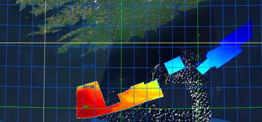
BY_Mallet_CelticSea_14m_WGS84
Description of measurements/samples, purpose for which they were collected, and the platforms/instrumentation and methods in collection RV Mallet 2019-2020 Legs Celtic Sea Cork 14m Globe DTM WGS 1984 projection Lowest Astronomical Tide (LAT). The GSI has been permitted to utilise the UKHO VORF (Vertical Offshore Reference Frame) sea surface model. This model allows the use of ‘GPS tides’ and the GSI has gridded this model to a 1km resolution around Ireland to 15km offshore for reducing all soundings to Lowest Astronomical Tide - LAT (VORF). By utilising ‘GPS tides’ there is no requirement to adjust for draft or squat as the water level is modelled over the seabed as measured to the WGS84 ellipsoid. This area was surveyed as part of the ongoing INFOMAR project (formerly Irish National Seabed Survey), a joint seabed mapping project between the Geological Survey Ireland and the Marine Institute. Survey work was conducted to standards and recommendations set out by INFOMAR, the International Hydrographic Organisation (IHO), the United Kingdom Hydrographic Office (UKHO) and the UK’s Maritime and Coastguard Agency (MCA). Please note the following: Data acquired prior to March 2011 were levelled to Lowest Astronomical Tide (LAT) using shifts derived from Proudman Oceanographic tidal model. Tidal height was derived using a network of offshore and onshore tide gauges. As such data are on average 0.54m deeper than the more recent UKHO Vertical Offshore Reference Frame (VORF) levelled data. We are currently updating the older datasets. Statement on the level of data processed and quality control, limitations on reliability INFOMAR bathymetry products generated to meet International Hydrographic Organization (IHO) standards to ensure gridded data positional accuracy in the horizontal (XY) and vertical (Z) frame. Arrangement of data Data has been processed and arranged into a GLOBE DTM grid using XYZ data. Spatial and temporal resolution of data within the dataset Image resolution is a 14m DTM grid. Length of time series Image created from data collected between 2019-07-17 and 2020-10-31 Amount of data expressed in number of stations, sites, observations, cores, months of recordings, miles of track or other units as appropriate Bathymetry image meets GLOBE DTM standard. Data provided under Creative Commons licence access and use conditions. Users of this data should provide the following attribution statement "Contains Irish Public Sector Data (INFOMAR, Geological Survey Ireland; Marine Institute) licensed under a Creative Commons Attribution 4.0 International (CC BY 4.0) licence"
Simple
- Alternate title
-
KN172L08 SeaBeam 3012-P1 Bathymetry Grid
- Date (Creation)
- 2021-12-13T00:00:00
- Date (Revision)
- 2021-12-13T00:00:00
- Citation identifier
- BY_Mallet_CelticSea_14m_WGS84
- Point of contact
-
Organisation name Individual name Electronic mail address Role Geological Survey Ireland
Originator Geological Survey Ireland
Custodian
-
Project name
-
-
EMODNet Bathymetry
-
-
SeaDataNet device categories
-
-
multi-beam echosounders
-
multi-beam echosounders
-
-
SeaDataNet device categories
-
-
multi-beam echosounders
-
Differential Global Positioning System receivers
-
-
Parameter Discovery Vocabulary (P02)
-
-
Bathymetry and Elevation
-
-
GEMET - INSPIRE themes, version 1.0
-
-
Hydrography
-
- Access constraints
- Creative Commons Attribution 4.0 International
- Use constraints
- Other restrictions
- Other constraints
-
DO NOT USE FOR NAVIGATION
- Denominator
- 100000
- Distance
- 0.000130208334 degree
- Language
- English
- Character set
- UTF8
- Topic category
-
- Oceans
- Begin date
- 2018-07-17T09:00:00
- End date
- 2020-09-15T09:00:00
))
- Geographic identifier
- http://vocab.nerc.ac.uk/collection/C19/current/1_6/
- Description
-
Map projection parameters, values and units :
Axes units :
UPPER LEFT X=29.3054583250
UPPER LEFT Y=44.6262830219
LOWER RIGHT X=40.7816282263
LOWER RIGHT Y=41.2281769950
WEST LONGITUDE=29° 18' 19.6500" E
NORTH LATITUDE=44° 37' 34.6189" N
EAST LONGITUDE=40° 46' 53.8616" E
SOUTH LATITUDE=41° 13' 41.4372" N
PROJ_DESC=Geographic (Latitude/Longitude) / WGS84 / arc degrees
PROJ_DATUM=WGS84
PROJ_UNITS=arc degrees
EPSG_CODE=4326
COVERED AREA=353215 sq km
- Geographic identifier
- EPSG / WGS84 / Geographic coordinate system / 7.4
- Unique resource identifier
- EPSG:84
- Reference system identifier
- EPSG / WGS 84 (EPSG:4326) / 7.4
- Number of dimensions
- 3
- Dimension name
- Column
- Dimension size
- 17765
- Dimension name
- Row
- Dimension size
- 0
- Dimension name
- Time
- Dimension size
- 1
- Resolution
- 1 minute
- Cell geometry
- Point
- Transformation parameter availability
- No
- Checkpoint Availability
- No
- Point in Pixel
-
- Center
- Distribution format
-
Name Version NetCDF
4
- Transfer size
- 3810
- OnLine resource
-
Protocol Linkage Name WWW:LINK
https://tiles.emodnet-bathymetry.eu/ EMODnet Bathymetry WMTS service
WWW:LINK
https://emodnet.ec.europa.eu/geoviewer EMODnet viewer
WWW:DOWNLOAD
https://downloads.emodnet-bathymetry.eu/high_resolution/366_BY_Mallet_CelticSea_14m_WGS84.emo.zip
- Hierarchy level
- Dataset
Vertical extent
- Minimum value
- 72.66
- Maximum value
- 122.58
Vertical CS
Vertical datum
- Statement
-
no information
- Hierarchy level
- Feature
- Dataset
-
accuracy
Gridded data positional accuracy
- Name of measure
-
horizontal accuracy
- Measure identification
- horizontal accuracy of coordinate
Quantitative result
- Value type
- horizontal accuracy
Quantitative attribute accuracy
- Name of measure
-
depth
- Measure identification
- depth accuracy
Quantitative result
- Value
- not defined
Conformance result
- Title
-
Shoal bias
- Date
- Explanation
-
No shoals detected
- Pass
- Yes
- Hierarchy level
- Software
- Description
-
MB-System
- Other
-
software
- Hierarchy level
- Property type
- Description
-
parameters of data processing
Attributes
- Statement
-
EMODnet processing methodology using Globe software
- Description
-
MAL18_02_CelticSeaCorkWaterford_14m_WGS84
MAL19_01_CelticSeaCork_14m_WGS84
MAL19_02_CelticSea_14m_WGS84
MAL19_03_CelticSeaCork_14m_WGS84
MAL19_04_CelticSeaCork_14m_WGS84
MAL19_05_CelticSea_14m_WGS84
- Hierarchy level
- Dataset
Absolute external positional accuracy
- Name of measure
-
emodnet-bathymetry.QI.Horizontal
- Value
- -1 - Multisources
Absolute external positional accuracy
- Name of measure
-
emodnet-bathymetry.QI.Vertical
- Value
- -1 - Multisources
Domain consistency
- Name of measure
-
emodnet-bathymetry.QI.Purpose
- Value
- 3 - Hydrographic survey or compatible with hydrographic standards
Metadata
- File identifier
- SDN_CPRD_366_BY_Mallet_CelticSea_14m_WGS84 XML
- Metadata language
- English
- Character set
- UTF8
- Hierarchy level name
-
Composite Product Record
- Date stamp
- 2023-01-26T15:08:03.962Z
- Metadata standard name
-
ISO 19115:2003/19139 - EMODNET - BATHYMETRY
- Metadata standard version
-
1.0
- Metadata author
-
Organisation name Individual name Electronic mail address Role Geological Survey Ireland
Author
)))
