 EMODnet product catalogue
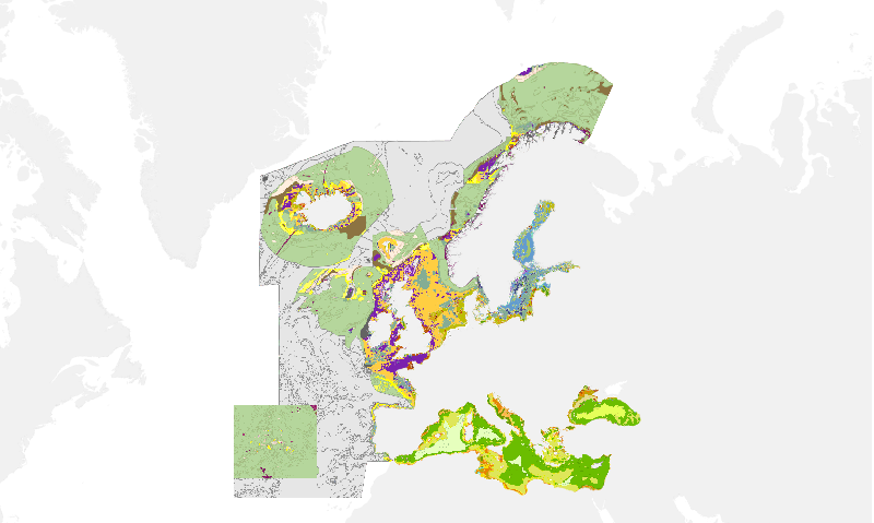
EUSeaMap2 (2016) Broad-Scale Predictive Habitat Map
Output of the 2016 EUSeaMap broad-scale predictive model, produced by EMODnet Seabed Habitats.
The extent of the mapped area includes the Mediterranean Sea, Black Sea, Baltic Sea, and areas of the North Eastern Atlantic extending from the Canary Islands in the south to Norway in the North.
The map was produced using a "top-down" modelling approach using classified habitat descriptors to determine a final output habitat.
Habitat descriptors differ per region but include:
Biological zone
Energy class
Oxygen regime
Salinity regime
Seabed Substrate
Riverine input
Habitat descriptors (excepting Substrate) are calculated using underlying physical data and thresholds derived from statistical analyses or expert judgement on known conditions.
The model is produced in Arc Model Builder (10.1).
The model was created using raster input layers with a cell size of 0.002dd (roughly 250 meters). The model includes the sublittoral zone only; due to the high variability of the littoral zone, a lack of detailed substrate data and the resolution of the model, it is difficult to predict littoral habitats at this scale.
The map follows the EUNIS 2007-11 classification system where it is appropriate.
For details on methodology see:
Populus J. And Vasquez M. (Eds), 2017. EUSeaMap, a European broad-scale seabed habitat map. Ifremer
Available from: http://archimer.ifremer.fr/doc/00388/49975/
Simple
- Date (Publication)
- 2016-09-30
- Date (Creation)
- 2016-09-30
- Credit
-
EMODnet broad-scale seabed habitat map for Europe (2016), licensed under CC-BY 4.0 from the European Marine Observation and Data Network (EMODnet) Seabed Habitats initiative (www.emodnet-seabedhabitats.eu), funded by the European Commission.
- Status
- Completed
- Point of contact
-
Organisation name Individual name Electronic mail address Role EMODnet Seabed Habitats
Owner
-
GEMET - INSPIRE themes, version 1.0
-
-
Habitats and biotopes
-
- Use limitation
-
Licensed under CC-BY 4.0 - please use attribution statement included within the "Credit" element.
- Access constraints
- Other restrictions
- Other constraints
-
Please use attribution statement included within the "Credit" element.
- Denominator
- 250000
- Language
- English
- Topic category
-
- Biota
- Environment
- Oceans
))
- Begin date
- 1975-01-01
- End date
- 2015-12-31
- Reference system identifier
- EPSG / WGS 84 (EPSG:4326) / 7.4
- Distribution format
-
Name Version Web Mapping Service
1.1.0
- OnLine resource
-
Protocol Linkage Name WWW:LINK-1.0-http--link
http://www.emodnet-seabedhabitats.eu/access-data/launch-map-viewer/?LAYERS=EUSM2016&zoom=3&Y=39&X=-8.525390623910205 EMODnet Seabed Habitats interactive map
WWW:LINK-1.0-http--link
http://www.emodnet-seabedhabitats.eu/access-data/download-data/?linkid=1 EMODnet Seabed Habitats Download page (EUSeaMap preselected)
OGC:WMS-1.1.1-http-get-map
http://www.emodnet-seabedhabitats.eu/access-data/launch-map-viewer EUSM2016
WWW:LINK-1.0-http--link
http://archimer.ifremer.fr/doc/00388/49975/ EUSeaMap 2016 Techical report and MSFD Look up tables
- Hierarchy level
- Dataset
Conformance result
- Date (Publication)
- Pass
- Statement
-
Black Sea Habitats list and correlation with MSFD BBHT updated in June 2018 following a Black Sea experts workshop.
An accompanying confidence layer is available for viewing and download from EMODnet Seabed Habitats.
Details on methodology available from: http://archimer.ifremer.fr/doc/00388/49975/
Metadata
- File identifier
- 02a444c8-bd2d-4e15-8e69-806059103760 XML
- Metadata language
- English
- Character set
- MD_CharacterSetCode_utf8
- Hierarchy level
- Dataset
- Date stamp
- 2020-01-15T12:22:05
- Metadata standard name
-
ISO19115
- Metadata standard version
-
2003/Cor.1:2006
- Metadata author
-
Organisation name Individual name Electronic mail address Role EMODnet Seabed Habitats
Point of contact
)))
