 EMODnet product catalogue
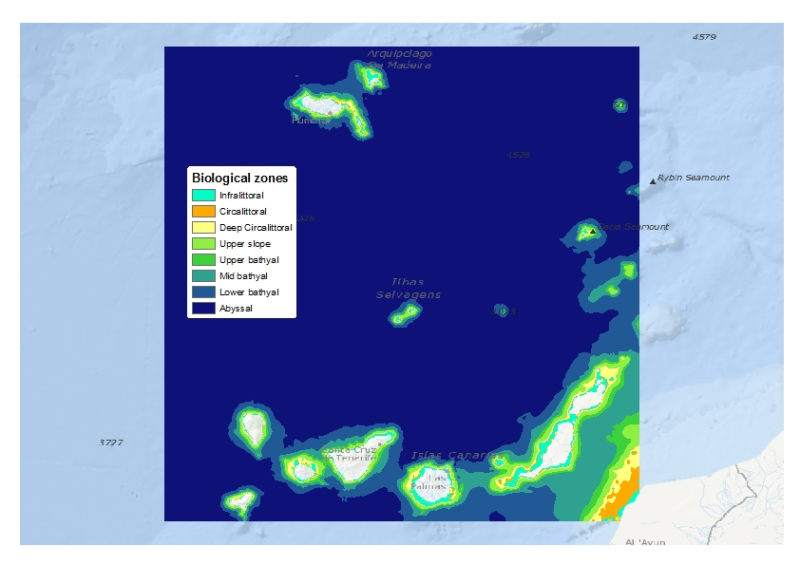
Biological zones of the Canary Islands and Madeira archipelago - Scale 1:1,000,000
This layer is a model of the biological zones of the Canary Islands and Madeira archipelago. It was performed within the framework of EMODnet Phase 2 Thematic Lot n┬░ 3 (aka EUSeaMap2). It is a preliminary version which will be refined during the course of the project.
This layer was modelled with the use of base layers that were the bathymetry (Gebco_08) and the kdpar (bespoke computed layer)
The biological zones boundaries were defined in the following way.
- Infralittoral lower limit: limit at which the percentage of light reaching the seabed is 1%. The percentage of light layer was calculated by intersecting the kdpar and the bathymetry layers. For more details about this calculation see e.g. Cameron and Askew (2011).
- Circalittoral lower limit: depth 80m
- Deep circalittoral lower limit: depth 200m
- Upper slope lower limit: depth 750m
- Upper bathyal lower limit: depth 1100m
- Mid bathyal lower limit: depth 1800m
- Lower bathyal lower limit: depth 2700m
Deep biological zones (from upper slope to abyssal) were chosen according to the classification proposed by Howell (2010).
For more details about the current layer see EUSeaMap first year report (EMODnet Thematic Lot n┬░ 3, 2014)
Cameron, A., Askew, N. (eds.), 2011. EUSeaMap - Preparatory Action for development and assessment of a European broad-scale seabed habitat map final report. URL: http://jncc.gov.uk/euseamap
EMODnet Thematic Lot n┬░ 3, 2014. EMODnet Phase 2 - Annual (interim) report. Reporting Period: Sept. 2013 to Aug. 2014. URL: http://www.emodnet-seabedhabitats.eu/pdf/20140909_euseamap2_year1_report.pdf
Howell, K.L., 2010. A benthic classification system to aid in the implementation of marine protected area networks in the deep/high seas of the NE Atlantic. Biological Conservation 143, 1041ÔÇô1056.
Simple
- Date (Publication)
- 2014-10-10T08:00:00
- Edition
-
v1
- Presentation form
- Digital map
- Purpose
-
Marine spatial planning
- Status
- Completed
- Point of contact
-
Organisation name Individual name Electronic mail address Role Ifremer
Mickaël VASQUEZ
Point of contact
- Maintenance and update frequency
- As needed
- Theme
-
-
biological zones
-
EUNIS
-
infralittoral
-
circalittoral
-
upper slope
-
upper bathyal
-
mid bathyal
-
lower bathyal
-
Abyssal
-
Madeira
-
Canary
-
Marine habitat mapping
-
-
GEMET - INSPIRE themes, version 1.0
-
-
Habitats and biotopes
-
Oceanographic geographical features
-
Bio-geographical regions
-
Hydrography
-
- Use limitation
-
Data is freely available for research or commercial use providing that the originators are acknowledged in any publications produced
- Other constraints
-
has to be cited this way in other maps: "Source EMODnet"
- Spatial representation type
- Vector
- Denominator
- 1000000
- Language
-
eng
- Character set
- UTF8
- Topic category
-
- Environment
- Begin date
- 2014-10-16T04:00:00
- End date
- 2014-10-16T04:00:00
))
Vertical extent
- Minimum value
- 0
- Maximum value
- 6000
- Reference system identifier
- WGS 1984
- Distribution format
-
Name Version Esri Shapefile unknown
- OnLine resource
-
Protocol Linkage Name WWW:LINK-1.0-http--link
http://www.emodnet-seabedhabitats.eu/default.aspx?page=1934 WWW:DOWNLOAD-1.0-http--download
http://gis.ices.dk/geonetwork/srv/en/resources.get?id=598&fname=&access=private OGC:WMS-1.1.1-http-get-map
Metadata
- File identifier
- 031f9ceb-2a2f-4221-9a58-c5d17d3e27f8 XML
- Metadata language
-
eng
- Character set
- UTF8
- Date stamp
- 2026-03-11T09:17:46.1159751Z
- Metadata standard name
-
ISO 19115:2003/19139
- Metadata standard version
-
1.0
- Metadata author
-
Organisation name Individual name Electronic mail address Role Ifremer
Mickaël VAsquez
Point of contact
Overviews

Spatial extent
)))
Provided by
