 EMODnet product catalogue
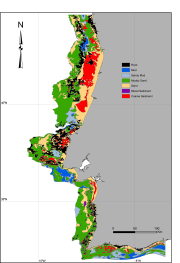
Chart of the Portuguese continental shelf sediments
Simplified map of the superficial sediments of the Portuguese continental shelf, based on available information of marine charts and various surveys.Preliminary map preparation involved scanning, georeferencing and digitizing of pre-existing base maps from the Portuguese Hydrographic Institute and harmonization with other published and non-published cartographic information. Samples of soft bottom shelf sediments from nearly 500 sites, collected in the scope of the MeshAtlantic, RENSUB and ACOSHELF projects, were analyzed for grain-size and total organic matter.
Simple
- Alternate title
-
PT001000
- Alternate title
-
PT001001
- Alternate title
-
PT001002
- Alternate title
-
PT001003
- Alternate title
-
PT001004
- Alternate title
-
PT001005
- Alternate title
-
PT001006
- Date (Creation)
- 2011-05-20T15:31:00
- Presentation form
- Digital map
- Purpose
-
Research
- Status
- Completed
- Point of contact
-
Organisation name Individual name Electronic mail address Role University of Aveiro
Ant├│nio Silva & Rosa Freitas
Author
- Maintenance and update frequency
- As needed
- Place
-
-
Portuguese continental shelf
-
- Theme
-
-
Marine habitat mapping
-
-
GEMET - INSPIRE themes, version 1.0
-
-
Sediments map
-
- Access constraints
- Copyright
- Spatial representation type
- Vector
- Denominator
- 2100000
- Language
-
eng
- Character set
- UTF8
- Begin date
- 1984-01-01T10:00:00
- End date
- 2010-06-15T16:58:00
))
Vertical extent
- Minimum value
- 0
- Maximum value
- -500
- Supplemental Information
-
The classification system used was the FOLK-MESH ATLANTIC used in the MeshAtlantic project.
- Reference system identifier
- WGS 1984
- Distribution format
-
Name Version Shapefile
ESRI ArcGIS
- OnLine resource
-
Protocol Linkage Name WWW:LINK-1.0-http--link
OGC:WMS
https://ows.emodnet-seabedhabitats.eu/geoserver/emodnet_view_maplibrary/wms? pt001002
OGC:WFS
https://ows.emodnet-seabedhabitats.eu/geoserver/emodnet_open_maplibrary/wfs? pt001002
WWW:LINK-1.0-http--link
https://files.emodnet-seabedhabitats.eu/data/EMODnetSBHsurvey_PT001002.zip EMODnet Seabed Habitats download
- Hierarchy level
- Dataset
Conformance result
- Title
-
Chart of the Portuguese continental shelf sediments
- Date (Creation)
- 2011-05-20
- Explanation
-
┬À a literature review of the existing information on the sedimentary distribution on the
Portuguese continental shelf;
┬À scanning of pre-existing and published maps by the Portuguese Hydrographic
Institute ÔÇô Instituto Hidrogr├ífico (IH), 1:500.000 scale, with the distribution of the
surficial sediments on the Portuguese continental shelf;
┬À georreferencing the obtained raster images to the world WGS-84 geographic
coordinate system;
┬À vectorization of the Portuguese mainland coastline and the bathymetric curves of
20m, 50m, 100m, 200m and 500m;
┬À projection of the sedimentological data (grain size) obtained in the oceanographic
campaigns associated with the project and subsequent classification within the
system FOLK MESH-ATLANTIC, using the tool GRAPHERTM 7 (Golden Software,
Inc.);
┬À representation and analysis of the sediment samples from the Portuguese
continental shelf in the map produced in ArcGIS;
┬À harmonization of sedimentological data available in the literature reviewed,
particularly in the maps published by IH, with the classification system adopted in
FOLK MESH-ATLANTIC project. This phase required in some cases,
georreferencing new maps of interest;
┬À vectorization and mapping the sedimentological maps published in the IHÔÇÖs ÔÇ£S├®rie
PescaÔÇØ and "Carta dos Sedimentos Superficiais da Plataforma Continental
Portuguesa";
┬À construction of a synthetic base map of the sediment distribution on the Portuguese
continental shelf. For this purpose it was necessary to consider the previous scientific
papers published on the sedimentological data of interest to the project;
┬À cataloguing of vector data (metadata) in "GeoNetwork OpensourceÔÇØ platform using a
template according to the ISO19139 standard.
- Pass
- No
Metadata
- File identifier
- 13d40ad4-c9c3-4c9c-a3dc-79d11d30d139 XML
- Metadata language
-
eng
- Character set
- UTF8
- Date stamp
- 2020-01-15T12:11:26
- Metadata standard name
-
ISO 19115:2003/19139
- Metadata standard version
-
1.0
- Metadata author
-
Organisation name Individual name Electronic mail address Role University of Aveiro
Ant├│nio Silva & Rosa Freitas
Author

)))
