 EMODnet product catalogue
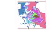
Habitats LIC Banco de Galicia
This dataset contains the main habitats maps from the SCI (Site of Community Importance) ÔÇ£Banco de GaliciaÔÇØ. The Galician Bank is a deep underwater mountain located at the northwest of the Iberian Peninsula, 180 km from the Galician coast (in the north-east Atlantic Ocean). Its summit is located at a depth of between 650 and 1,500 metres. Its steep slopes descend from the summit to the abyssal plains located 4,000 meters below sea level. This study was supported by the INDEMARES-LIFE+ Project, EC contract INDEMARES-LIFE+ (07/NAT/E/000732): Inventory and Designation of the Natura 2000 network in marine areas of the Spanish State (www.indemares.es/en). This work was coordinated by the Spanish Institute of Oceanography (IEO, www.ieo.es) and the Biodiversity Foundation (www.fundacion-biodiversidad.es). The interpretation has been made possible thanks to direct and indirect samplings and geophysical data from campaigns "ECOMARG09", "INDEMARES_BANGAL0810", "INDEMARES_BANGAL0711" and "RADPROF0912". Habitats are classified according to EUNIS nomenclature and the List of Marine Habitats in Spain (LPRE, that itÔÇÖs classified hierarchically and was completed and published in March 2013).
Simple
- Alternate title
-
ES001021
- Date (Revision)
- 2015-10-05T00:00:00
- Presentation form
- Digital map
- Purpose
-
Marine habitats research and seabed habitats distribution mapping for Marine Natura 2000 Network areas declaration. It was performed with geophysical data and direct and indirect samplings obtained in the Project INDEMARES Banco de Galicia (LIFE+ 07/NAT/E/000732). The study area is situated in the north-east Atlantic Ocean (northwest of the Iberian Peninsula). We would like to thank the captains and all the crews of R/V Cornide de Saavedra, R/V Thalassa and R/V Miguel Oliver.
- Status
- Completed
- Point of contact
-
Organisation name Individual name Electronic mail address Role Fundaci├│n Biodiversidad (Biodiversity Fundation)
Fundaci├│n Biodiversidad
Point of contact Instituto Español de Oceanografía (Spanish Institute of Oceanography) (IEO)
Instituto Español de Oceanografía (IEO)
Owner Instituto Español de Oceanografía (Spanish Institute of Oceanography) (IEO)
Alberto Serrano L├│pez
Principal investigator
- Maintenance and update frequency
- Not planned
- Theme
-
-
Marine habitat mapping
-
INDEMARES
-
LIFE
-
LIFE+
-
Instituto Español de Oceanografía
-
FUNDACIÓN BIODIVERSIDAD
-
EMODNET
-
EUSeaMap
-
Galician Bank
-
Benthos
-
Bentos
-
Habitat
-
Hábitat
-
Seabed
-
Fondo marino
-
Banco de Galicia
-
-
GEMET - INSPIRE themes, version 1.0
-
-
Habitats and biotopes
-
Hábitats y biotopos
-
Protected sites
-
Lugares protegidos
-
Species distribution
-
Distribuci├│n de las especies
-
Rasgos oceanográficos
-
Geology
-
Geología
-
Biology
-
Biología
-
- Use limitation
-
The use of this information, totally or partly, requires the source citation: Spanish Institute of Oceanography (IEO, www.ieo.es) and Biodiversity Fundation (www.fundacion-biodiversidad.es), Spain.
- Access constraints
- Other restrictions
- Use constraints
- Other restrictions
- Other constraints
-
The use of this information, totally or partly, requires the source citation: Spanish Institute of Oceanography (IEO, www.ieo.es) and Biodiversity Fundation (www.fundacion-biodiversidad.es), Spain.
- Spatial representation type
- Vector
- Denominator
- 500000
- Language
-
eng
- Character set
- UTF8
- Topic category
-
- Environment
- Begin date
- 2009-10-01T00:00:00
- End date
- 2013-12-02T00:00:00
))
Vertical extent
- Minimum value
- 5000
- Maximum value
- 500000
- Reference system identifier
- WGS 1984
- Distribution format
-
Name Version Shapefile
ESRI ArcGIS 10.1
- OnLine resource
-
Protocol Linkage Name WWW:LINK-1.0-http--link
https://www.emodnet-seabedhabitats.eu/access-data/launch-map-viewer/?zoom=9¢er=-11.87574,42.75685&layerIds=501&baseLayerId=1&activeFilters=NobwRANghgngpgJwJIBMwC4CsAGAjAGjADMBLCAF0VQwBYB2Q0ixAGQHs2BrAVwAdUAzhmABdRmUoIAKnAAe5DGACiAZWx5sAJlxgAviKA EMODnet Seabed Habitats Map Viewer
OGC:WMS
https://ows.emodnet-seabedhabitats.eu/geoserver/emodnet_view_maplibrary/wms? es001021
OGC:WFS
https://ows.emodnet-seabedhabitats.eu/geoserver/emodnet_open_maplibrary/wfs? es001021
WWW:LINK-1.0-http--link
https://files.emodnet-seabedhabitats.eu/data/EMODnetSBHsurvey_ES001021.zip EMODnet Seabed Habitats download
- Hierarchy level
- Dataset
Conformance result
- Title
-
ES001021 Habitats LIC Banco de Galicia
- Date (Publication)
- 2015-10-05
- Explanation
-
EMODnetSBH Confidence assessment scoresheet = 89
- Pass
- Yes
- Statement
-
Manual translation: Each EUNIS habitat within the map was manually determined and entered by an expert.
Metadata
- File identifier
- 1c71c6c0-3335-490c-bc5c-a3e3ea782c05 XML
- Metadata language
-
eng
- Character set
- UTF8
- Date stamp
- 2020-01-15T11:59:59
- Metadata standard name
-
ISO 19115:2003/19139
- Metadata standard version
-
1.0
- Metadata author
-
Organisation name Individual name Electronic mail address Role INSTITUTO ESPAÑOL DE OCEANOGRAFÍA (Spanish Institute of Oceanography) (IEO)
Instituto Español de Oceanografía (IEO)
Point of contact INSTITUTO ESPAÑOL DE OCEANOGRAFÍA (Spanish Institute of Oceanography) (IEO)
Olvido Tello Ant├│n
Custodian
)))
