• EMODnet Product Catalogue
  •  
  •  
  •  

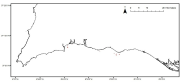
Maerl beds distribution in Portugal mainland

Maerl beds distribution in the Portuguese mainland from historical data. Data published in: “Present distribution of maerl beds in the Atlantic Iberian Peninsula”. Museologia Scientifica e Naturalista. Volume Speciale 2009

Identificatie

Alternatieve titel PT000005
Type versiedatum Wijziging: Datum van wijziging, controle, verbetering van dataset.

Inhoud

Doel van vervaardiging Provide information on the distribution of historical Maerl beds in the Portuguese continental coast
Status historisch archief: De data is opgeslagen in een offline opslagmedium.

Contactgegevens dataset(serie)

Naam Contactpersoon Luis Bentes & Jorge Gonçalves
Organisatie University of Algarve (UAlg-FCT)- Centre of Marine Science (CCMAR)
Telefoon +351 289 800069 (ext7367)
Adres Universidade do Algarve (CCMAR-FCT)
Adres Campus de Gambelas Edificio 7
Plaats Faro
Postcode 8005-139 Faro
Land Portugal
E-mail lbentes@ualg.pt
E-mail jgoncal@ualg.pt
Rol Auteur: Partij die auteur is van de data.

Contactgegevens dataset(serie)

Naam Contactpersoon Dr. Viviana Peña
Organisatie Universidade da Coruña
Telefoon +34 981 167 000
Adres Universidade da Coruña
Adres Rúa da Maestranza,9
Plaats A Coruña
Postcode 15001 A Coruña
Land Spain
E-mail vpena@udc.es
Rol Contactpunt: Partij waarmee contact kan worden opgenomen voor het vergaren van kennis of verstrekking van de data.
Frequentie Niet gepland: Er zijn geen plannen om de data te actualiseren.
Voorbeeldweergave dataset(serie) https://gis.ices.dk/geonetwork/srv/api/records/375e0788-4f80-4d91-b011-fd6812df7f1d/attachments/Maerl_s.png

Trefwoorden

GEMET - INSPIRE themes, version 1.0 Habitat map
GDI-Vlaanderen Trefwoorden Metadata GDI-Vl-conform
Overige trefwoorden Habitat
Overige trefwoorden Portugal
Ruimtelijk schema dataset(serie) vector: Vector data wordt gebruikt om geografische data te representeren.

Ruimtelijke resolutie dataset(serie)

Noemer 10000
Karakterset UTF-8: 8-bit variabele grootte universele karakterset, gebaseerd op ISO/IEC 10646
Categorie(ën) Biota

Begrenzing

Omschrijving geografische begrenzing
Identificator geografische begrenzing

Begrenzing

Omschrijving geografische begrenzing

Omschrijvende rechthoek

Minimum x-coordinaat -8.651
Maximum x-coordinaat -8.281
Minimum y-coordinaat 37.05
Maximum y-coordinaat 37.123
Identificator geografische begrenzing

Begrenzing

Omschrijving geografische begrenzing
Identificator geografische begrenzing

Referentiesysteem

Horizontaal en/of verticaal referentiesysteem

Unieke code WGS 1984

Kwaliteit

Niveau kwaliteitsinformatie Dataset: Informatie heeft betrekking op de dataset.

Toegangs- en gebruiksbeperkingen

Legale en veiligheidsbeperkingen

Beperkingen van de dataset(serie)

Legale beperkingen

Beschrijving The access and use might be possible with request to Dr. Viviana Peña
(Juridische) toegangsbeperking licentie: Formele toestemming om iets te doen.
(Juridische) gebruiksbeperking licentie: Formele toestemming om iets te doen.

Distributie

Distributieformaat Shapefile (Version: Esri ArcGis)

Overdracht

OnLine bronnen

Protocol WWW:LINK-1.0-http--link

OnLine bronnen

Connectiepunt URL https://www.emodnet-seabedhabitats.eu/access-data/launch-map-viewer/?zoom=11&center=-8.46746,37.08729&layerIds=501&baseLayerId=1&activeFilters=NobwRANghgngpgJwJIBMwC4CsAGAjAGjADMBLCAF0VQwBYB2Q0ixAGQHs2BrAVwAdUAzhmABdRmUoIAKnAAe5DGAAKU7GrWYwAXxFA
Protocol WWW:LINK-1.0-http--link
Naam EMODnet Seabed Habitats Map Viewer
Beschrijving View map "PT000005" on the EMODnet Seabed Habitats Map Viewer

OnLine bronnen

Connectiepunt URL https://www.emodnet-seabedhabitats.eu/access-data/download-data/?gui=PT000005
Protocol WWW:LINK-1.0-http--link
Naam EMODnet Seabed Habitats Download Page
Beschrijving Visit the EMODnet Seabed Habitats download page with map "PT000005" preselected for download

OnLine bronnen

Connectiepunt URL https://ows.emodnet-seabedhabitats.eu/emodnet_view_maplibrary/wms?
Protocol OGC:WMS
Naam pt000005
Beschrijving View map "PT000005" through the EMODnet Seabed Habitats "Map Library" Web Map Service

OnLine bronnen

Connectiepunt URL https://ows.emodnet-seabedhabitats.eu/emodnet_open_maplibrary/wfs?
Protocol OGC:WFS
Naam pt000005
Beschrijving Access data from map "PT000005" through the EMODnet Seabed Habitats "Map Library" Web Feature Service

Meta-metadata

Metadata identificator (fileIdentifier) 375e0788-4f80-4d91-b011-fd6812df7f1d
Karakterset metadatarecord UTF-8: 8-bit variabele grootte universele karakterset, gebaseerd op ISO/IEC 10646
Metadata wijzigingsdatum 2020-01-23T10:55:12
Naam metadatastandaard ISO 19115:2003/19139
Versie metadatastandaard 1.0

Metadata-auteur

Naam Contactpersoon Luis Bentes & Jorge Gonçalves
Organisatie University of Algarve (UAlg-FCT)- Centre of Marine Science (CCMAR)
Telefoon +351 289 800069 (ext7367)
Plaats Faro
Postcode 8005-139 Faro
Land Portugal
E-mail lbentes@ualg.pt
E-mail jgoncal@ualg.pt
Rol Contactpunt: Partij waarmee contact kan worden opgenomen voor het vergaren van kennis of verstrekking van de data.

Overviews

Maerl_s.png