 EMODnet product catalogue
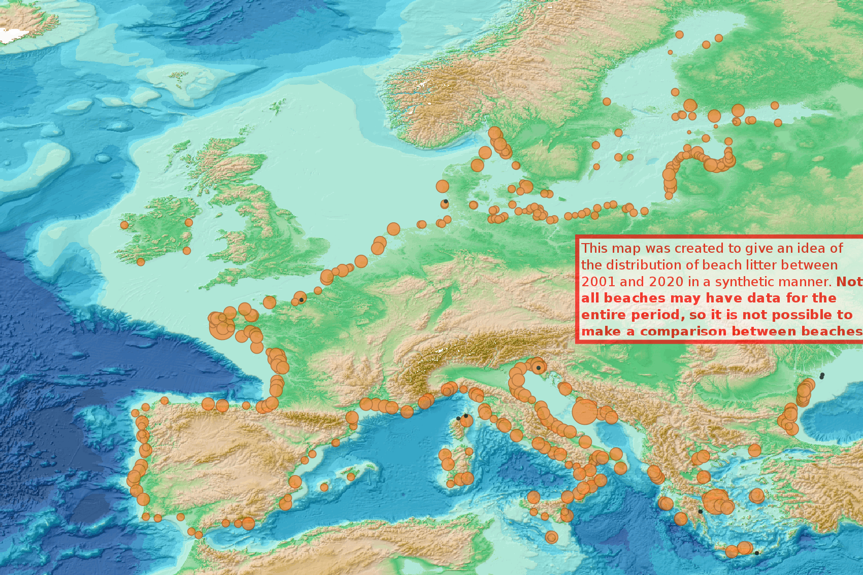
Beach litter - Total abundance (No. Items) of litter aggregated over a given period per beach - EU-MSFD monitoring 2001/2022 v2023
This visualization product displays the total abundance of marine macro-litter (> 2.5cm) per beach, per 100m & to 1 survey aggregated over the period 2001 to 2020 from Marine Strategy Framework Directive (MSFD) monitoring surveys.
EMODnet Chemistry included the collection of marine litter in its 3rd phase. Since the beginning of 2018, data of beach litter have been gathered and processed in the EMODnet Chemistry Marine Litter Database (MLDB).
The harmonization of all the data has been the most challenging task considering the heterogeneity of the data sources, sampling protocols and reference lists used on a European scale.
Preliminary processing were necessary to harmonize all the data:
- Exclusion of OSPAR 1000 protocol: in order to follow the approach of OSPAR that it is not including these data anymore in the monitoring;
- Selection of MSFD surveys only (exclusion of other monitoring, cleaning and research operations);
- Exclusion of beaches without coordinates;
- Some categories & some litter types like organic litter, small fragments (paraffin and wax; items > 2.5cm) and pollutants have been removed. The list of selected items is attached to this metadata (total abundance list). This list was created using EU Marine Beach Litter Baselines and EU Threshold Value for Macro Litter on Coastlines from JRC (these two documents are attached to this metadata);
- Normalization of survey lengths to 100m & 1 survey / year: in some cases, the survey length was not exactly 100m, so in order to be able to compare the abundance of litter from different beaches a normalization is applied using this formula:
Number of items (normalized by 100 m) = Number of litter per items x (100 / survey length)
Then, this normalized number of items is summed to obtain the total normalized number of litter for each survey. Finally, a median is calculated over the entire period among all these total numbers of litter per 100m calculated for each survey.
Sometimes the survey length was null or equal to 0. Assuming that the MSFD protocol has been applied, the length has been set at 100m in these cases.
The size of each circle on this map increases with the calculated median number of marine litter per beach, per 100m & to 1 survey.
The median litter abundance values displayed in the legend correspond to the 50 and 99 percentiles and the maximum value.
More information is available in the attached documents.
Warning:
- the absence of data on the map doesn't necessarily mean that they don't exist, but that no information has been entered in the Marine Litter Database for this area.
- This map was created to give an idea of the distribution of beach litter between 2001 and 2021 in a synthetic manner. NOT ALL BEACHES MAY HAVE DATA FOR THE ENTIRE PERIOD, SO IT IS NOT POSSIBLE TO MAKE A COMPARISON BETWEEN BEACHES.
Simple
- Alternate title
-
bl_tot_abundance_all_years_beach_monitoring
- Date (Creation)
- 2023-06-12
- Edition
-
1.0
- Citation identifier
- DOI:10.13120/3adba042-b2e6-40a8-a40a-13f80217376e
- Credit
-
EMODnet Chemistry
Point of contact
Point of contact
-
Thèmes Sextant
-
-
/Human Activities/Pollution
-
- Theme
-
-
EMODnet Chemistry
-
-
Ocean Hackathon - City and challenge
-
-
/Boulogne-sur-Mer/BOL02
-
/Boulogne-sur-Mer/BOL04
-
/Boulogne-sur-Mer/BOL06
-
/Bournemouth/BOR01
-
/Concepción/CON06
-
/Kuala Lumpur/KUL08
-
/La Rochelle/LAR01
-
/Peniche/PEN01
-
- Use limitation
-
CC BY 4.0: https://creativecommons.org/licenses/by/4.0/
- Access constraints
- Other restrictions
- Use constraints
- Creative Commons Attribution 4.0 International
- Other constraints
-
Usage is subject to mandatory citation: "This resource was generated in the framework of EMODnet Chemistry, under the support of DG MARE Call for Tender EASME/EMFF/2018/1.3.1.8 - lot4."
- Spatial representation type
- Vector
- Language
-
eng
- Topic category
-
- Oceans
- Description
-
bounding box
))
- Begin date
- 2001-01-01
- End date
- 2022-11-17
Vertical extent
- Minimum value
- 0
- Maximum value
- 0.0
- Reference system identifier
- EPSG / WGS 84 (EPSG:4326)
- Geometric object type
- Point
- Distribution format
-
Name Version
- OnLine resource
- Hierarchy level
- Series
Conformance result
- Title
-
COMMISSION REGULATION (EU) No 1089/2010 of 23 November 2010 implementing Directive 2007/2/EC of the European Parliament and of the Council as regards interoperability of spatial data sets and services
- Date (Publication)
- 2010-12-08
- Explanation
-
See the referenced specification
- Statement
-
The data used as input data for this product was extracted from the Postgis database used in the beach litter analysis for EMODnet Chemistry.
Metadata
- File identifier
- 3adba042-b2e6-40a8-a40a-13f80217376e XML
- Metadata language
- English
- Character set
- UTF8
- Hierarchy level
- Series
- Hierarchy level name
-
Product record
- Date stamp
- 2025-02-21T09:20:34.600251Z
- Metadata standard name
-
ISO 19115:2003/19139 - EMODNET - SDN
- Metadata standard version
-
1.0
- Metadata author
-
Organisation name Individual name Electronic mail address Role EMODnet Chemistry
Point of contact
)))
