 EMODnet product catalogue
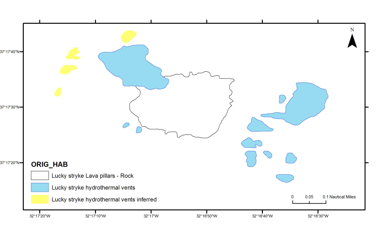
Azores: Lucky Strike substrate map
Historical habitats map for Lucky Strike substrate map (Mid-Atlantic Ridge). The Lucky Strike segment, located southwest of the Azores Islands, is 60 km long. Yellows domains correspond to areas with abundant inferred hydrothermal edifices and sulfide debris, where active and dead chimneys have been observed. Blue domains correspond to domains where hydrothermal activity is inferred based on scarce dive data. Black contour is the limit of the lava. Ondr├®as, H., M. Cannat, Y. Fouquet, A. Normand, P. M. Sarradin, and J. Sarrazin (2009), Recent volcanic events and the distribution of hydrothermal venting at the Lucky Strike hydrothermal field, Mid-Atlantic Ridge, Geochem. Geophys.
Geosyst., 10, Q02006, doi:10.1029/2008GC002171.
Simple
- Alternate title
-
PT100000
- Date (Publication)
- 2012-08-27T16:38:00
- Edition
-
Version 1.0
- Presentation form
- Digital map
- Purpose
-
Research supported by MeshAtlantic project
- Status
- Historical archive
- Point of contact
-
Organisation name Individual name Electronic mail address Role DOP/IMAR University of the Azores
Patricia Amorim & Fernando Tempera
Point of contact
- Maintenance and update frequency
- Not planned
- Place
-
-
Azores
-
- Theme
-
-
Marine habitat mapping
-
-
GEMET - INSPIRE themes, version 1.0
-
-
Habitats and biotopes
-
- Access constraints
- Copyright
- Spatial representation type
- Vector
- Denominator
- 10000
- Language
-
eng
- Character set
- UTF8
- Topic category
-
- Environment
- Begin date
- 2009-01-01T00:00:00
- End date
- 2009-12-31T02:00:00
Vertical extent
- Minimum value
- 0
- Maximum value
- -1750
))
- Reference system identifier
- WGS 1984
- Distribution format
-
Name Version Shapefile
ESRI ArcGIS 10
- OnLine resource
-
Protocol Linkage Name WWW:LINK-1.0-http--link
OGC:WMS
https://ows.emodnet-seabedhabitats.eu/geoserver/emodnet_view_maplibrary/wms? pt100000
OGC:WFS
https://ows.emodnet-seabedhabitats.eu/geoserver/emodnet_open_maplibrary/wfs? pt100000
WWW:LINK-1.0-http--link
https://files.emodnet-seabedhabitats.eu/data/EMODnetSBHsurvey_PT100000.zip EMODnet Seabed Habitats download
- Hierarchy level
- Dataset
Conformance result
- Title
-
Azores historical habitats maps
- Date (Publication)
- 2012-08-27
- Explanation
-
Historical marine habitats maps collected for the Azores region
- Pass
- No
Metadata
- File identifier
- 5ef5375c-f369-4e79-ab9c-546fe3d11adb XML
- Metadata language
-
eng
- Character set
- UTF8
- Date stamp
- 2020-01-23T10:24:04
- Metadata standard name
-
ISO 19115:2003/19139
- Metadata standard version
-
1.0
- Metadata author
-
Organisation name Individual name Electronic mail address Role DOP/IMAR University of the Azores
Patricia Amorim and Fernando Tempera
Point of contact

)))
