 EMODnet product catalogue
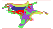
HABITATS LIC CANAL DE MENORCA
This dataset contains the habitats map from the SCI (Site of Community Importance) ÔÇ£Canal de MenorcaÔÇØ. The "Menorca Channel" is a marine corridor located between the islands of Mallorca and Menorca in the Balearic Islands archipelago, with a minimum distance between the two islands of 36 kilometers. Its geographical position in the centre of the Western Mediterranean and its location, between islands, gives the area a peculiar set of oceanographic characteristics, including strong currentsand unusually transparent waters. This study was supported by the INDEMARES-LIFE+ Project, EC contract INDEMARES-LIFE+ (07/NAT/E/000732): Inventory and Designation of the Natura 2000 network in marine areas of the Spanish State (www.indemares.es/en). This work was coordinated by the Biodiversity Foundation (www.fundacion-biodiversidad.es). Habitats are classified according to EUNIS nomenclature and the List of Marine Habitats in Spain (LPRE, that itÔÇÖs classified hierarchically and was completed and published in March 2013). Habitats classification are been simplified owing to the requirements of the EMODnet (European Marine Observation and Data Network ) portal for Seabed Habitats.
Simple
- Alternate title
-
ES001025
- Date (Revision)
- 2015-10-05T00:00:00
- Presentation form
- Digital map
- Purpose
-
Marine habitats research and seabed habitats distribution mapping for Marine Natura 2000 Network areas declaration. It was performed with geophysical data and direct and indirect samplings obtained in the Project INDEMARES Canal de Menorca (LIFE+ 07/NAT/E/000732). The study area is situated in the centre of the Western Mediterranean, next to Balearic Islands.
- Status
- Completed
- Point of contact
-
Organisation name Individual name Electronic mail address Role Fundaci├│n Biodiversidad (Biodiversity Fundation)
Fundaci├│n Biodiversidad
Owner Instituto Español de Oceanografía (Spanish Institute of Oceanography) (IEO)
Instituto Español de Oceanografía (IEO)
Point of contact Instituto Español de Oceanografía (Spanish Institute of Oceanography) (IEO)
Joan Moranta
Point of contact Instituto Español de Oceanografía (Spanish Institute of Oceanography) (IEO)
Alberto Serrano L├│pez
Principal investigator
- Maintenance and update frequency
- Not planned
- Theme
-
-
Marine habitat mapping, INDEMARES, LIFE, LIFE+, Instituto Español de Oceanografía, FUNDACIÓN BIODIVERSIDAD, EMODNET, EUSeaMap, Mediterranean Sea, Illes Balears, Islas Baleares, Balearic Islands, Benthos, Bentos, Habitat, Hábitat, Seabed, Fondo marino
-
-
GEMET - INSPIRE themes, version 1.0
-
-
Habitats and biotopes, Hábitats y biotopos, Protected sites, Lugares protegidos, Species distribution, Distribución de las especies, Rasgos oceanográficos, Hidrografía, Geology, Geología, Biology, Biología
-
- Use limitation
-
The use of this information, totally or partly, requires the source citation: Spanish Institute of Oceanography (IEO, www.ieo.es) and Biodiversity Fundation (www.fundacion-biodiversidad.es), Spain.
- Access constraints
- Copyright
- Other constraints
-
The use of this information, totally or partly, requires the source citation: Spanish Institute of Oceanography (IEO, www.ieo.es) and Biodiversity Fundation (www.fundacion-biodiversidad.es), Spain.
- Spatial representation type
- Vector
- Denominator
- 500000
- Language
-
eng
- Character set
- UTF8
- Topic category
-
- Environment
- Begin date
- 2009-10-01T00:00:00
- End date
- 2013-12-02T00:00:00
))
Vertical extent
- Minimum value
- 4000
- Maximum value
- 50000
- Reference system identifier
- WGS 1984
- Distribution format
-
Name Version Shapefile
ESRI ArcGIS 10.1
- OnLine resource
-
Protocol Linkage Name OGC:WMS
https://ows.emodnet-seabedhabitats.eu/geoserver/emodnet_view_maplibrary/wms? es001025
OGC:WFS
https://ows.emodnet-seabedhabitats.eu/geoserver/emodnet_open_maplibrary/wfs? es001025
WWW:LINK-1.0-http--link
https://files.emodnet-seabedhabitats.eu/data/EMODnetSBHsurvey_ES001025.zip EMODnet Seabed Habitats download
- Hierarchy level
- Dataset
Conformance result
- Title
-
ES001025 Habitats LIC Canal de Menorca
- Date (Publication)
- 2015-10-05
- Explanation
-
EMODnetSBH Confidence assessment scoresheet = 89
- Pass
- Yes
Metadata
- File identifier
- 7e3b8965-4313-48a7-8259-89b85ed956e0 XML
- Metadata language
-
eng
- Character set
- UTF8
- Date stamp
- 2020-01-15T12:33:56
- Metadata standard name
-
ISO 19115:2003/19139
- Metadata standard version
-
1.0
- Metadata author
-
Organisation name Individual name Electronic mail address Role INSTITUTO ESPAÑOL DE OCEANOGRAFÍA (Spanish Institute of Oceanography) (IEO)
Instituto Español de Oceanografía (IEO)
Point of contact INSTITUTO ESPAÑOL DE OCEANOGRAFÍA (Spanish Institute of Oceanography) (IEO)
Olvido Tello Ant├│n
Custodian
)))
