 EMODnet product catalogue
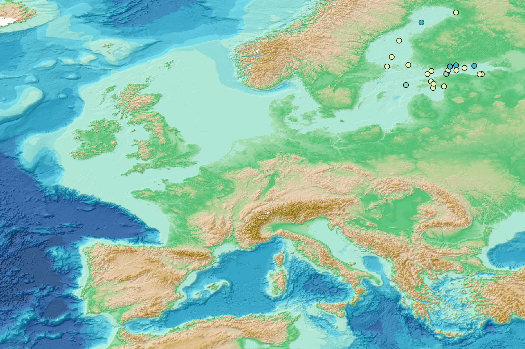
Micro litter - Density per net normalized per liter - Research and monitoring protocols 2016/2021 v2023
This visualization product displays the density of floating micro-litter per net normalized per liter per year from research and monitoring protocols.
EMODnet Chemistry included the collection of marine litter in its 3rd phase. Before 2021, there was no coordinated effort at the regional or European scale for micro-litter. Given this situation, EMODnet Chemistry proposed to adopt the data gathering and data management approach as generally applied for marine data, i.e., populating metadata and data in the CDI Data Discovery and Access service using dedicated SeaDataNet data transport formats. EMODnet Chemistry is currently the official EU collector of micro-litter data from Marine Strategy Framework Directive (MSFD) National Monitoring activities (descriptor 10).
A series of specific standard vocabularies or standard terms related to micro-litter have been added to SeaDataNet NVS (NERC Vocabulary Server) Common Vocabularies to describe the micro-litter.
European micro-litter data are collected by the National Oceanographic Data Centres (NODCs). Micro-litter map products are generated from NODCs data after a test of the aggregated collection including data and data format checks and data harmonization.
A filter is applied to represent only micro-litter sampled according to research and monitoring protocols as MSFD monitoring.
Densities were calculated for each net using the following calculation:
Density (number of particles per liter) = Micro-litter count / Sampling effort (l)
When the number of microlitters was not filled, the density could not be calculated.
Percentiles 50, 75, 95 & 99 have been calculated taking into account data for all years.
Warning: the absence of data on the map doesn't necessarily mean that they don't exist, but that no information has been entered in the National Oceanographic Data Centre (NODC) for this area.
Simple
- Alternate title
-
mlf_density_nb_l_monitoring
- Date (Creation)
- 2023-07-25
- Edition
-
1.0
- Citation identifier
- DOI:10.13120/7e6d00e9-65d4-4673-89bd-761e1dd1ba04
- Credit
-
EMODnet Chemistry
Point of contact
-
Thèmes Sextant
-
-
/Human Activities/Pollution
-
- Theme
-
-
EMODnet Chemistry
-
-
Mission Atlantic - Resources
-
-
Data
-
-
Mission Atlantic - Case Studies
-
-
Celtic Seas
-
-
Mission Atlantic - Work Package
-
-
WP4 Benthic Mapping
-
-
Mission Atlantic - BODC Parameters
-
-
/Environment/Pollution
-
-
Mission Atlantic - Data type (DMP)
-
-
Spatial data products
-
-
Ocean Hackathon - City and challenge
-
-
/Boulogne-sur-Mer/BOL02
-
/Boulogne-sur-Mer/BOL04
-
/Boulogne-sur-Mer/BOL06
-
/Bournemouth/BOR01
-
/Concepción/CON06
-
/Kuala Lumpur/KUL08
-
/La Rochelle/LAR01
-
/Peniche/PEN01
-
- Use limitation
-
CC BY 4.0: https://creativecommons.org/licenses/by/4.0/
- Access constraints
- Other restrictions
- Use constraints
- Creative Commons Attribution 4.0 International
- Other constraints
-
Usage is subject to mandatory citation: "This resource was generated in the framework of EMODnet Chemistry, under the support of DG MARE Call for Tender EASME/EMFF/2018/1.3.1.8 - lot4."
- Spatial representation type
- Vector
- Language
-
eng
- Description
-
bounding box
))
- Begin date
- 2016-04-21
- End date
- 2021-11-03
Vertical extent
- Minimum value
- -5500.0
- Maximum value
- 0.0
- Reference system identifier
- EPSG / WGS 84 (EPSG:4326)
- Geometric object type
- Point
- Distribution format
-
Name Version
- OnLine resource
-
Protocol Linkage Name WWW:LINK
https://doi.org/10.6092/d3e239ec-f790-4ee4-9bb4-c32ef39b426d Guidelines and formats for gathering micro-litter data
WWW:LINK
https://sextant.ifremer.fr/documentation/emodnet_chemistry/document/Field_description/MLF_field_description_density_groupby.xlsx Description of the layer's fields
WWW:DOWNLOAD
https://sextant.ifremer.fr/sextant_data/EMODNET/CHEMISTRY/MARINE_LITTER/2023/mlf_density_nb_l_monitoring.zip Direct Download
WWW:LINK
https://emodnet.ec.europa.eu/geoviewer/ EMODnet Map Viewer
DOI
https://doi.org/10.13120/7e6d00e9-65d4-4673-89bd-761e1dd1ba04 Digital Object Identifier (DOI)
- Hierarchy level
- Series
Conformance result
- Title
-
COMMISSION REGULATION (EU) No 1089/2010 of 23 November 2010 implementing Directive 2007/2/EC of the European Parliament and of the Council as regards interoperability of spatial data sets and services
- Date (Publication)
- 2010-12-08
- Explanation
-
See the referenced specification
- Statement
-
The data used as input for this product have been extracted from the EMODnet Chemistry Download Service: https://emodnet-chemistry.maris.nl/search
Metadata
- File identifier
- 7e6d00e9-65d4-4673-89bd-761e1dd1ba04 XML
- Metadata language
- English
- Character set
- UTF8
- Hierarchy level
- Series
- Hierarchy level name
-
Product record
- Date stamp
- 2025-02-21T09:18:58.500631Z
- Metadata standard name
-
ISO 19115:2003/19139 - EMODNET - SDN
- Metadata standard version
-
1.0
- Metadata author
-
Organisation name Individual name Electronic mail address Role EMODnet Chemistry
Point of contact
)))
