 EMODnet product catalogue
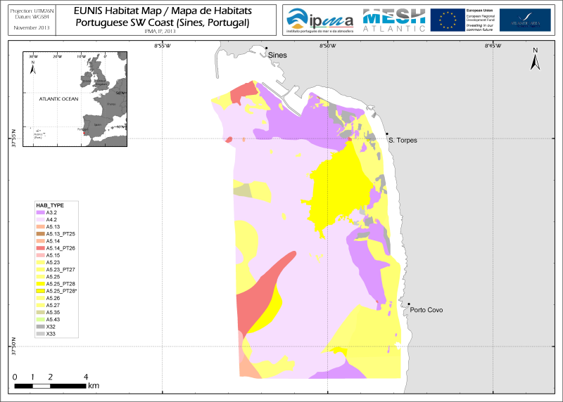
Map of seabed habitats and associated communities in Sines coastal area (SW Portugal)
The map shows the seabed habitat types and associated benthic communities distribution in the coastal area south of Sines (SW Portugal), which is partly included in the Special Protection Area (PTZPE0015) of the Natural Park of Sudoeste Alentejano e Costa Vicentina. The data were obtained during the new survey crarried out in 2011 within the framework of the MeshAtlantic Project.
The survey area is an area of moderate energy under the influence of wave action and tidal currents. The northern near shore area is partially exposed to the outfalls of a thermoelectric powerplant. Physical and biological datasets were combined aiming at matching the habitat classes defined in the EUNIS classification.
Simple
- Alternate title
-
PT010001
- Date (Creation)
- 2013-11-01T17:16:00
- Edition
-
version 1.0
- Presentation form
- Digital map
- Purpose
-
Nature conservation; regulation of human activities; research
- Status
- On going
- Point of contact
-
Organisation name Individual name Electronic mail address Role Instituto Português do Mar e da Atmosfera (IPMA)
Victor Henriques
Author Instituto Português do Mar e da Atmosfera (IPMA)
Miriam Tuaty Guerra
Author
- Maintenance and update frequency
- As needed
- Place
-
-
Sines, Portugal
-
- Theme
-
-
Marine habitat mapping
-
-
GEMET - INSPIRE themes, version 1.0
-
-
Habitats and biotopes
-
- Use limitation
-
Not for commercial use. Any other use strictly under permission from, and according to any conditions imposed by the coordinator IPMA.
- Access constraints
- Copyright
- Use constraints
- Other restrictions
- Other constraints
-
Any requests for use must be sent to victorh@ipma.pt or mguerra@ipma.pt
- Other constraints
-
Reference citation is required in the bibliography.
- Spatial representation type
- Vector
- Denominator
- 25000
- Language
-
eng
- Character set
- UTF8
- Topic category
-
- Environment
- Begin date
- 2011-08-11T12:08:00
- End date
- 2011-08-16T00:00:00
))
Vertical extent
- Minimum value
- -50
- Maximum value
- 0
- Supplemental Information
-
This product was developed in the framework of the MeshAtlantic project by the IPMA partner. The data used were:
Survey data: grain size data, subtidal benthic macro- and megauna of soft sediments, acoustics remote sensing (AGDS and Sidescan sonnar).
Data type: qualitative and quantitative (abundance).
Depth interval: 0 to -50m.
Data periods: 2011
Geographic area: The coastal area south of Sines (SW Portugal), which is partly included in the Special Protection Area (PTZPE0015) of the Natural Park of Sudoeste Alentejano e Costa Vicentina.
Data sources: Databases generated in the frameworks of the MeshAtlantic project
Methods:
a) acoustics remote sensing (AGDS and Sidescan sonnar);
b) Sampling: Smith_McIntyre grab (0.1 m2);
c) Macrofauna abundance data analysis performed in the statistical software PRIMER v6.
Reference citation:
Henriques, V., Guerra, M.T., Mendes, B. & Gaudêncio, M.J., 2013. Map of seabed habitats and associated communities in Sines coastal area (SW Portugal) according to the EUNIS classification. PT010001. Instituto Português do Mar e da Atmosfera (IPMA), Lisboa, Portugal.
- Reference system identifier
- WGS 1984
- Distribution format
-
Name Version Shapefile
ESRI ArcGIS 9.2
- OnLine resource
-
Protocol Linkage Name WWW:LINK-1.0-http--link
https://files.emodnet-seabedhabitats.eu/data/EMODnetSBHsurvey_PT010001.zip EMODnet Seabed Habitats download
- Hierarchy level
- Dataset
Conformance result
- Title
-
Map of seabed habitats and associated communities in Sines coastal area (SW Portugal)
- Date (Creation)
- 2013-11-01
- Explanation
-
The datasets were analysed in conformance with the standards defined in the framework of the MeshAtlantic Project
- Pass
- Yes
Metadata
- File identifier
- 7e753090-000c-43a4-a5ac-efccb3245c93 XML
- Metadata language
-
eng
- Character set
- UTF8
- Date stamp
- 2020-01-15T12:33:02
- Metadata standard name
-
ISO 19115:2003/19139
- Metadata standard version
-
1.0
- Metadata author
-
Organisation name Individual name Electronic mail address Role Instituto Português do Mar e da Atmosfera (IPMA)
Victor Henriques
Author
)))
