 EMODnet product catalogue
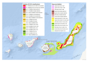
Broad-scale habitat map of the Canary Islands - Scale 1:1,000,000
This layer is a predictive EUNIS seabed habitat map for the Canary Islands. It was performed within the framework of EMODnet Phase 2 Thematic Lot n┬░ 3 (aka EUSeaMap2). It is a preliminary version which will be refined during the course of the project.
The layer was created using two pre-processed input datasets: substrate and biological zone.
The seabed substrate type layer was a compendium of historical maps (Emodnet phase 2 Geology lot first release + Datasets from Instituto Español de Oceanografía). The biological zones layer, available in this catalog under the title 'Biological zones of the Canary Islands and Madeira archipelago', was modeled thanks to layers of bathymetry and light attenuation.
The map follows the EUNIS 2007-11 classification system supplemented by additional categories in deep sea areas (Howell et al., 2010). The map does not include the intertidal zone.
The study followed the methodology developped within the EUSeaMap project (EMODnet phase 1). For more details about the methodology see EUSeaMap final report (Cameron and Askew, 2011) or Coltman et al., 2008. For more details about the current map see EUSeaMap2 interim report (EMODnet Thematic Lot n┬░ 3, 2014)
Cameron, A., Askew, N. (eds.), 2011. EUSeaMap - Preparatory Action for development and assessment of a European broad-scale seabed habitat map final report. URL: http://jncc.gov.uk/euseamap
Coltman, N., Golding, N., Verling, E., 2008. Developing a broadscale predictive EUNIS habitat map for the MESH study area. 16 pp. URL: https://www.emodnet-seabedhabitats.eu/resources/mesh-archive/.
EMODnet Thematic Lot n┬░ 3, 2014. EMODnet Phase 2 - Annual (interim) report. Reporting Period: Sept. 2013 to Aug. 2014. URL: http://www.emodnet-seabedhabitats.eu/pdf/20140909_euseamap2_year1_report.pdf
Howell, K.L., 2010. A benthic classification system to aid in the implementation of marine protected area networks in the deep/high seas of the NE Atlantic. Biological Conservation 143, 1041ÔÇô1056.
Simple
- Date (Publication)
- 2014-10-10T08:00:00
- Edition
-
v1
- Presentation form
- Digital map
- Purpose
-
Marine spatial planning
- Status
- Completed
- Point of contact
-
Organisation name Individual name Electronic mail address Role Ifremer
Mickaël VASQUEZ
Point of contact
- Maintenance and update frequency
- As needed
- Theme
-
-
broad-scale
-
EUNIS
-
habitat
-
seabed
-
Canary
-
EMODnet
-
Marine habitat mapping
-
-
GEMET - INSPIRE themes, version 1.0
-
-
Habitats and biotopes
-
Oceanographic geographical features
-
Bio-geographical regions
-
Hydrography
-
- Use limitation
-
Data is freely available for research or commercial use providing that the originators are acknowledged in any publications produced
- Other constraints
-
has to be cited this way in other maps: "Source EMODnet"
- Spatial representation type
- Vector
- Denominator
- 1000000
- Language
-
eng
- Character set
- UTF8
- Topic category
-
- Environment
- Begin date
- 2014-10-16T04:00:00
- End date
- 2014-10-16T04:00:00
))
Vertical extent
- Minimum value
- 0
- Maximum value
- 6000
- Reference system identifier
- WGS 1984
- Distribution format
-
Name Version Shapefile
unknown
- OnLine resource
-
Protocol Linkage Name WWW:LINK-1.0-http--link
http://www.emodnet-seabedhabitats.eu/default.aspx?page=1934 OGC:WMS-1.1.1-http-get-map
- Hierarchy level
- Dataset
Conformance result
- Title
-
Broad-scale habitat map of the Canary Islands
- Date (Publication)
- 2014-10-15
- Explanation
-
Union of substrate and biological zone
- Pass
- No
Metadata
- File identifier
- 9666f040-a695-4fda-aa20-6aea48044f17 XML
- Metadata language
-
eng
- Character set
- UTF8
- Date stamp
- 2022-04-28T15:20:25.388Z
- Metadata standard name
-
ISO 19115:2003/19139
- Metadata standard version
-
1.0
- Metadata author
-
Organisation name Individual name Electronic mail address Role Ifremer
Mickaël VAsquez
Point of contact

)))
