 EMODnet product catalogue
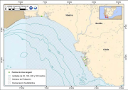
Littoral muddy sand sediments associated to Uca tangeri along the southatlantic spanish coast
Spatial distribution along the southatlantic spanish coast of the habitat: Littoral muddy sand sediments associated to Uca tangeri. Study of the spatial distribution of the species by marine demarcations attending the area covered by the species within the Marine Strategy Framework Directive. The cartographic representation of the species is interpreted as one of the indicators proposed by the Commission for the study of the biodiversity of species, habitats and ecosystems.
This information is from the Spanish Marine Strategy, belongs to the good environmental condition and initial evaluation of the Marine Southatlantic Demarcation.
Simple
- Alternate title
-
ES001019
- Date (Publication)
- 2012-11-13T13:17:00
- Presentation form
- Digital map
- Purpose
-
Provide information on the Spanish Marine Habitat distribution to achieve or maintain good environmental status of the marine environment by the year 2020.
- Status
- Completed
- Point of contact
-
Organisation name Individual name Electronic mail address Role Spanish Oceanographic Institute
Olvido Tello
Point of contact
- Maintenance and update frequency
- Not planned
- Theme
-
-
Marine Strategy Framework Directive
-
Marine habitat mapping
-
-
GEMET - INSPIRE themes, version 1.0
-
-
Habitats and biotopes
-
- Use limitation
-
The access and use is possible with request to the Ministry of Agriculture, Food and Environment, General Technical Secretariat
- Access constraints
- Copyright
- Use constraints
- Copyright
- Spatial representation type
- Vector
- Denominator
- 1000000
- Language
-
eng
- Character set
- UTF8
- Topic category
-
- Environment
))
Vertical extent
- Reference system identifier
- WGS 1984
- Distribution format
-
Name Version Shapefile
ESRI ArcGIS 10.1
- OnLine resource
-
Protocol Linkage Name WWW:LINK-1.0-http--link
https://www.emodnet-seabedhabitats.eu/resources/mesh-archive/ WWW:DOWNLOAD-1.0-http--download
http://gis.ices.dk/geonetwork/srv/en/resources.get?id=525&fname=&access=private WWW:DOWNLOAD-1.0-http--download
http://gis.ices.dk/geonetwork/srv/en/resources.get?id=525&fname=&access=private
- Hierarchy level
- Dataset
Conformance result
- Date
- Pass
- No
Metadata
- File identifier
- 981f192a-2d74-4731-b24a-5f5054925f65 XML
- Metadata language
-
eng
- Character set
- UTF8
- Date stamp
- 2022-02-18T09:49:33
- Metadata standard name
-
ISO 19115:2003/19139
- Metadata standard version
-
1.0
- Metadata author
-
Organisation name Individual name Electronic mail address Role Spanish Oceanographic Institute
Dulce Mata Chac├│n
Point of contact
)))
