 EMODnet product catalogue
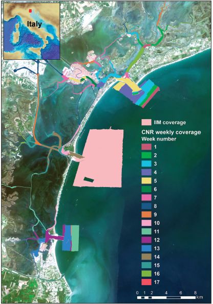
VENICE LAGOON CHANNELS DTM 5 m
The multibeam data were collected during six-months in 2013 with a Kongsberg EM2040 compact dual-head multi-frequency system. Metadata for the 17-week-long survey is available from the Seadatanet catalogue CDIs: 145_CNR-ISMAR-102,145_CNR-ISMAR-103,145_CNR-ISMAR-104,145_CNR-ISMAR-105,145_CNR-ISMAR-106,145_CNR-ISMAR-107,145_CNR-ISMAR-108,145_CNR-ISMAR-109,145_CNR-ISMAR-110,145_CNR-ISMAR-111,145_CNR-ISMAR-112,145_CNR-ISMAR-113,145_CNR-ISMAR-114,145_CNR-ISMAR-115,145_CNR-ISMAR-116,145_CNR-ISMAR-117,145_CNR-ISMAR-118.
Simple
- Date (Creation)
- 2017-07-03T00:00:00
- Date (Revision)
- 2018-02-18
- Citation identifier
- DTM_CNR-ISMAR-124
- Point of contact
-
Organisation name Individual name Electronic mail address Role CNR, Institute of Marine Science (ISMAR) - Bologna
Originator CNR, Institute of Marine Science (ISMAR) - Bologna
Custodian
-
Parameter Discovery Vocabulary (P02)
-
-
Bathymetry and Elevation
-
-
SeaDataNet device categories
-
-
multi-beam echosounders
-
-
Positioning devices
-
-
Differential Global Positioning System receivers
-
-
Vertical Datum
-
-
sea level
-
-
Project name
-
-
EMODnet HRSM
-
-
Thèmes Sextant
-
-
/Physical Environment/Bathymetry/Digital Terrain Model
-
- Access constraints
- Creative Commons Attribution 4.0 International
- Use constraints
- Other restrictions
- Other constraints
-
DO NOT USE FOR NAVIGATION
- Spatial representation type
- Grid
- Denominator
- 5000
- Distance
- 0.00390625 Arc minute
- Language
- English
- Character set
- UTF8
- Topic category
-
- Oceans
- Begin date
- 2013-05-01
- End date
- 2013-12-31 After
Vertical extent
- Minimum value
- 0
- Maximum value
- 41
- Description
-
Adriatic Sea
))
- Reference system identifier
- EPSG / WGS 84 (EPSG:4326) / 7.4
- Number of dimensions
- 3
- Dimension name
- Column
- Dimension size
- 325
- Dimension name
- Row
- Dimension size
- 340
- Dimension name
- Time
- Dimension size
- 1
- Resolution
- 1 second
- Cell geometry
- Point
- Transformation parameter availability
- No
- Checkpoint Availability
- No
- Point in Pixel
-
- Center
- Distribution format
-
Name Version XYZ Ascii
- Transfer size
- 144
- OnLine resource
-
Protocol Linkage Name WWW:DOWNLOAD
https://downloads.emodnet-bathymetry.eu/high_resolution/145_DTM_CNR-ISMAR-124.emo.zip WWW:LINK
https://tiles.emodnet-bathymetry.eu/ EMODnet Bathymetry WMTS service
WWW:LINK
https://emodnet.ec.europa.eu/geoviewer EMODnet viewer
- Hierarchy level
- Dataset
Conformance result
- Title
-
Shoal bias
- Date
- Pass
- No
Quantitative attribute accuracy
- Name of measure
-
depth
- Measure identification
- depth accuracy
- Measure description
-
Multibeam 200-400 kHz, Kongsberg EM2040
Quantitative result
- Value
- not defined
Gridded data positional accuracy
- Name of measure
-
horizontal accuracy
- Measure identification
- horizontal accuracy of coordinate
- Measure description
-
DGPS system
Quantitative result
- Value type
- horizontal accuracy
Absolute external positional accuracy
- Name of measure
-
emodnet-bathymetry.QI.Horizontal
- Value
- 3 - < 20 m
Absolute external positional accuracy
- Name of measure
-
emodnet-bathymetry.QI.Vertical
- Value
- 1 - MBES high frequency (higher than 100kHz)
Domain consistency
- Name of measure
-
emodnet-bathymetry.QI.Purpose
- Value
- 2 - Bathymetric/morphologic survey
- Hierarchy level
- Software
- Other
-
software
- Hierarchy level
- Property type
- Description
-
parameters of data processing
- Statement
-
Madricardo, F. et al. High resolution multibeam and hydrodynamic datasets of
tidal channels and inlets of the Venice Lagoon. Sci. Data 4:170121 doi: 10.1038/sdata.2017.121 (2017).
- Description
-
Metadata for the 17-week-long survey is available from the Seadatanet catalogue CDIs: 145_CNR-ISMAR-102,145_CNR-ISMAR-103,145_CNR-ISMAR-104,145_CNR-ISMAR-105,145_CNR-ISMAR-106,145_CNR-ISMAR-107,145_CNR-ISMAR-108,145_CNR-ISMAR-109,145_CNR-ISMAR-110,145_CNR-ISMAR-111,145_CNR-ISMAR-112,145_CNR-ISMAR-113,145_CNR-ISMAR-114,145_CNR-ISMAR-115,145_CNR-ISMAR-116,145_CNR-ISMAR-117,145_CNR-ISMAR-118. The multibeam system was pole-mounted on the CNR research vessel Litus. The MBES has 800 beams (400 per swath) 1° × 1°; the operational frequency for this survey was set at 360 kHz. A Seapath 300 system was used for ship positioning, supplied by a Fugro HP DGPS, accurate up to 0.2 m. The Kongsberg motion sensor MRU 5 and a Dual Antenna GPS integrated in the Seapath, corrected pitch, roll, heave and yaw movements (reaching 0.02° roll and pitch accuracy, and 0.075° heading accuracy). A Vale-port mini SVS sensor was attached close to the transducers to continuously measure the sound velocity for the beamforming. 640 sound velocity profiles were collected with an AML oceanographic Smart-X sound velocity profiler.
Metadata
- File identifier
- SDN_CPRD_145_DTM_CNR-ISMAR-124 XML
- Metadata language
- English
- Character set
- UTF8
- Hierarchy level name
-
Composite Product Record
- Date stamp
- 2022-09-21T09:09:38.606Z
- Metadata standard name
-
ISO 19115:2003/19139 - EMODNET - BATHYMETRY
- Metadata standard version
-
1.0
- Metadata author
-
Organisation name Individual name Electronic mail address Role CNR, Institute of Marine Science (ISMAR) - Bologna
Author
)))
