 EMODnet product catalogue
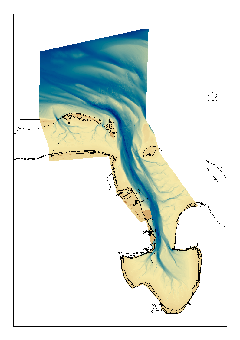
1850 HRDTM Jade approach
High resolution composite DTM based on single beam, multi beam and Lidar covering the Jade and Jade approach. All data acquired in the years 2016-2018. Data set is tiled in 1x1 km².
Simple
- Date (Creation)
- 2019-07-03
- Date (Revision)
- Citation identifier
- DGMW_JADE_v2
Point of contact
Point of contact
-
Parameter Discovery Vocabulary (P02)
-
-
Bathymetry and Elevation
-
-
SeaDataNet device categories
-
-
single-beam echosounders
-
multi-beam echosounders
-
-
Positioning devices
-
-
Differential Global Positioning System receivers
-
-
SeaDataNet depth measurement reference planes
-
-
Lowest Astronomical Tide
-
-
Project name
-
-
EMODnet HRSM
-
-
Thèmes Sextant
-
-
/Physical Environment/Bathymetry/Digital Terrain Model
-
-
GEMET - INSPIRE themes, version 1.0
-
-
Elevation
-
- Use limitation
-
Not for navigation
- Access constraints
- licence
- Use constraints
- Copyright
- Spatial representation type
- Grid
- Distance
- 1 meter
- Language
- English
- Character set
- UTF8
- Topic category
-
- Oceans
- Begin date
- 2016-12-17
- End date
- 2018-11-08
Vertical extent
))
- Reference system identifier
- EPSG / WGS 84 (EPSG:4326) / 7.4
- Number of dimensions
- 3
- Dimension name
- Column
- Dimension name
- Row
- Dimension name
- Time
- Dimension size
- 1
- Cell geometry
- Point
- Transformation parameter availability
- No
- Checkpoint Availability
- No
- Point in Pixel
-
- Distribution format
-
Name Version ESRI Grid, ASCII Grid
- Distributor contact
-
Organisation name Individual name Electronic mail address Role Federal Maritime and Hydrographic Agency
Distributor
- OnLine resource
- Hierarchy level
- Dataset
Conformance result
- Title
-
Shoal bias
- Date
- Pass
- No
Quantitative attribute accuracy
- Name of measure
-
depth
- Measure identification
- depth accuracy
Quantitative result
- Value
- not defined
Gridded data positional accuracy
- Name of measure
-
horizontal accuracy
- Measure identification
- horizontal accuracy of coordinate
Quantitative result
- Value type
- horizontal accuracy
Absolute external positional accuracy
- Name of measure
-
emodnet-bathymetry.QI.Horizontal
- Value
- 3 - < 20 m
Absolute external positional accuracy
- Name of measure
-
emodnet-bathymetry.QI.Vertical
- Value
- 3 - Lidar, SBES high frequency
Domain consistency
- Name of measure
-
emodnet-bathymetry.QI.Purpose
- Value
- 3 - Hydrographic survey or compatible with hydrographic standards
- Hierarchy level
- Software
- Other
-
software
- Hierarchy level
- Property type
- Description
-
parameters of data processing
- Other
-
data processing details
Metadata
- File identifier
- SDN_CPRD_1850_DGMW_JADE_v2 XML
- Metadata language
- English
- Character set
- UTF8
- Hierarchy level
- Dataset
- Hierarchy level name
-
Composite Product Record
- Date stamp
- 2023-05-05T08:29:52.639Z
- Metadata standard name
-
ISO 19115:2003/19139 - EMODNET - BATHYMETRY
- Metadata standard version
-
1.0
- Metadata author
-
Organisation name Individual name Electronic mail address Role Federal Maritime and Hydrographic Agency
Author
)))
