 EMODnet product catalogue
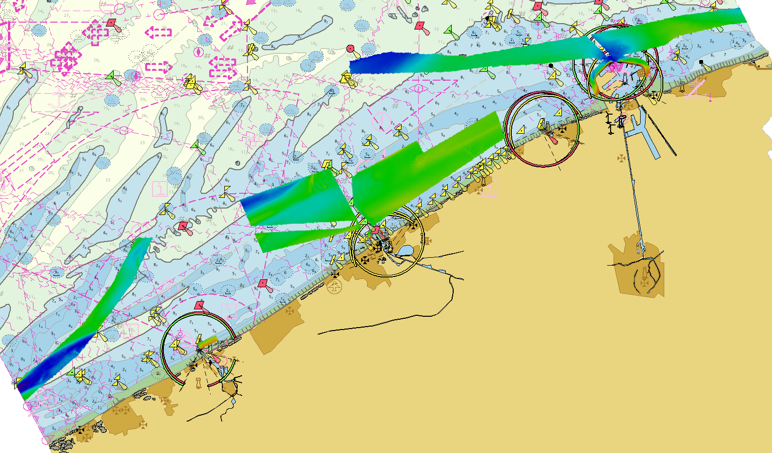
2243_EMODNet DTM of the Belgian Multibeam Surveys for the coastal waters
Source data for the EMODNet DTM for the Belgium Coastal Waters is compiled by the Vlaamse Hydrografie ( http://www.afdelingkust.be/en/bathymetric-database) at a resolution of 1/512 arc minute.
The data set covers the waters along the Belgian coast.
Simple
- Alternate title
-
BELGIUM_BCP_DTM01022018
- Date (Creation)
- 2018-02-01T10:45:00
- Date (Revision)
- 2018-02-01T14:45:00
- Citation identifier
- BELGIUM_MULTIBEAM_COASTAL_DTM010218
- Point of contact
-
Organisation name Individual name Electronic mail address Role Flemish Ministry of Mobility and Public Works; Agency for Maritime and Coastal Services; Coastal Division
Custodian Flemish Ministry of Mobility and Public Works; Agency for Maritime and Coastal Services; Coastal Division
Originator
-
Project name
-
-
EMODnet HRSM
-
-
SeaDataNet device categories
-
-
multi-beam echosounders
-
-
Parameter Discovery Vocabulary (P02)
-
-
Bathymetry and Elevation
-
-
GEMET - INSPIRE themes, version 1.0
-
-
Elevation
-
- Access constraints
- Creative Commons Attribution 4.0 International
- Use constraints
- Other restrictions
- Other constraints
-
DO NOT USE FOR NAVIGATION
- Spatial representation type
- Grid
- Denominator
- 50000
- Distance
- 0.001953 Arc minute
- Language
- English
- Character set
- UTF8
- Topic category
-
- Elevation
- Begin date
- 2016-09-20T09:00:00
- End date
- 2018-01-15T17:00:00 Before
))
- Geographic identifier
- North Sea
- Geographic identifier
- EPSG / Not projected / 7.4
- Reference system identifier
- EPSG / ETRS89 (EPSG:4258) / 8.6
- Distribution format
-
Name Version GeoTIFF
1.0
BAG
1.5.2
PNG
1.0
JPEG
1.0
XYZ Ascii
1.0
- Distributor contact
-
Organisation name Individual name Electronic mail address Role Flemish Ministry of Mobility and Public Works; Agency for Maritime and Coastal Services; Coastal Division
Distributor
- OnLine resource
-
Protocol Linkage Name WWW:LINK
https://www.afdelingkust.be/en/bathymetric-database WWW:DOWNLOAD
https://downloads.emodnet-bathymetry.eu/high_resolution/2243_BELGIUM_MULTIBEAM_COASTAL_DTM010218.emo.zip WWW:LINK
https://tiles.emodnet-bathymetry.eu/ EMODnet Bathymetry WMTS service
WWW:LINK
https://emodnet.ec.europa.eu/geoviewer EMODnet viewer
- Hierarchy level
- Dataset
Vertical extent
- Minimum value
- -5.2
- Maximum value
- 18.7
Vertical CS
Vertical datum
- Statement
-
no information
- Hierarchy level
- Feature
- Dataset
-
accuracy
Gridded data positional accuracy
- Name of measure
-
horizontal accuracy
- Measure identification
- horizontal accuracy of coordinate
- Measure description
-
IHO S-44
- Evaluation method description
-
IHO S-44
Quantitative result
- Value type
- Measure(s) (value(s) + unit(s))
- Value
- IHO S-44
Quantitative attribute accuracy
- Name of measure
-
depth
- Measure identification
- depth accuracy
- Measure description
-
IHO S-44
- Evaluation method description
-
IHO S-44
Quantitative result
- Value
- not defined
Conformance result
- Title
-
Shoal bias
- Date (Creation)
- Explanation
-
For multibeam survey the minimum, average and maximum depth are selected.
- Pass
- Yes
- Hierarchy level
- Software
- Description
-
CARIS BathyDatabase software suite
- Other
-
software
- Hierarchy level
- Property type
- Description
-
parameters of data processing
Attributes
- Statement
-
Description of data processing :
The original data is delivered in longitude/latitude (non projected) coordinates in the EMODnet format adding the required field using the CARIS BathyDatabase software suite.
List of the survey projects used to combine the EMODNet DTM for the Belgium Coastal Waters:
160920_ZB_STRD_MB_300 Strekdammen 1/512 arc minute
170209_WIESCH_MB_300 Zeegebied_Banken_Detail_Offshore_WIESCH 1/512 arc minute
170503_ZUYWE_MB_300 Zeegebied_Banken_Detail_Offshore_ZUYWE 1/512 arc minute
170627_WEDHA_MB_300 Zeegebied_Banken_Detail_Offshore_WEDHA 1/512 arc minute
170706_WEDHA_MB_300 Zeegebied_Banken_Detail_Offshore_WEDHA 1/512 arc minute
170922_OST_STRD_MB_300 Zeegebied_Havens_OST_STRD 1/512 arc minute
170927_ODKMK_MB_400 Lombardsijde 1/512 arc minute
171220_ODKMK_MB_400 Zeegebied_Vooroever_ODKMK 1/512 arc minute
180115_BKB_HAV_MB_300 Zeegebied_Havens_BKB_HAV 1/512 arc minute
- Description
-
Description of processed data sources: Description of processed data sources: various multibeam surveys collected for compilation of nautical charts.
- Hierarchy level
- Dataset
Absolute external positional accuracy
- Name of measure
-
emodnet-bathymetry.QI.Horizontal
- Value
- 3 - < 20 m
Absolute external positional accuracy
- Name of measure
-
emodnet-bathymetry.QI.Vertical
- Value
- 4 - MBES High frequency (higher that 100kHz) (1+0.5%d)
Domain consistency
- Name of measure
-
emodnet-bathymetry.QI.Purpose
- Value
- 3 - Hydrographic survey or compatible with hydrographic standards
Metadata
- File identifier
- SDN_CPRD_2243_BELGIUM_MULTIBEAM_COASTAL_DTM010218 XML
- Metadata language
- English
- Character set
- UTF8
- Hierarchy level name
-
Composite Product Record
- Date stamp
- 2025-03-07T14:08:18.622086Z
- Metadata standard name
-
ISO 19115:2003/19139 - EMODNET - BATHYMETRY
- Metadata standard version
-
1.0
- Metadata author
-
Organisation name Individual name Electronic mail address Role Flemish Ministry of Mobility and Public Works; Agency for Maritime and Coastal Services; Coastal Division
Author
)))
