 EMODnet product catalogue
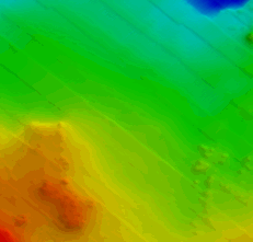
2917_CoNISMa_Uniroma1_27_AreaD_FD
The data have been acquired with a SeaBat RESON 7125 (frequency 450kHz and depth up to 150 m) multibeam echosounder mounted on board of the research vessel "Minerva 1" (party chief F. G. Falese) between 27 september and 5 october 2016. The main objective of this cruise was the search of relict sand deposits potentially exploitable for beach nourishment on these continental shelves. Weather and marine conditions were fair during the acquisition.
Simple
- Alternate title
-
KN172L08 SeaBeam 3012-P1 Bathymetry Grid
- Date (Creation)
- 2020-12-04T00:00:00
- Date (Revision)
- Invalid DateT00:00:00
- Citation identifier
- CoNISMa_Uniroma1_27_AreaD_FD
- Point of contact
-
Organisation name Individual name Electronic mail address Role University of Rome /Earth Science Department
Custodian CONISMA, National Interuniversity Consortium for Marine Science
Originator
-
Project name
-
-
EMODNet Bathymetry
-
-
SeaDataNet device categories
-
-
multi-beam echosounders
-
multi-beam echosounders
-
-
SeaDataNet device categories
-
-
Differential Global Positioning System receivers
-
-
Parameter Discovery Vocabulary (P02)
-
-
Bathymetry and Elevation
-
-
GEMET - INSPIRE themes, version 1.0
-
-
Hydrography
-
- Access constraints
- Creative Commons Attribution 4.0 International
- Use constraints
- Other restrictions
- Other constraints
-
DO NOT USE FOR NAVIGATION
- Spatial representation type
- Grid
- Denominator
- 10000
- Distance
- 0.46875 Arc second
- Language
- English
- Character set
- UTF8
- Topic category
-
- Oceans
- Begin date
- 2016-09-27T09:00:00
- End date
- 2016-10-05T09:00:00
))
- Description
-
Map projection parameters, values and units :
Axes units :
UPPER LEFT X=29.3054583250
UPPER LEFT Y=44.6262830219
LOWER RIGHT X=40.7816282263
LOWER RIGHT Y=41.2281769950
WEST LONGITUDE=29° 18' 19.6500" E
NORTH LATITUDE=44° 37' 34.6189" N
EAST LONGITUDE=40° 46' 53.8616" E
SOUTH LATITUDE=41° 13' 41.4372" N
PROJ_DESC=Geographic (Latitude/Longitude) / WGS84 / arc degrees
PROJ_DATUM=WGS84
PROJ_UNITS=arc degrees
EPSG_CODE=4326
COVERED AREA=353215 sq km
- Geographic identifier
- EPSG / WGS84 / Geographic coordinate system / 7.4
- Reference system identifier
- EPSG / WGS 84 (EPSG:4326) / 7.4
- Number of dimensions
- 3
- Dimension name
- Column
- Dimension size
- 82
- Dimension name
- Row
- Dimension size
- 79
- Dimension name
- Time
- Dimension size
- 1
- Resolution
- 9 day
- Cell geometry
- Point
- Transformation parameter availability
- No
- Checkpoint Availability
- No
- Point in Pixel
-
- Lower left
- Distribution format
-
Name Version NetCDF
3.5
- Transfer size
- 3.3
- OnLine resource
-
Protocol Linkage Name WWW:DOWNLOAD
https://downloads.emodnet-bathymetry.eu/high_resolution/2917_CoNISMa_Uniroma1_27_AreaD_FD.emo.zip WWW:LINK
https://tiles.emodnet-bathymetry.eu/ EMODnet Bathymetry WMTS service
WWW:LINK
https://emodnet.ec.europa.eu/geoviewer EMODnet viewer
- Hierarchy level
- Dataset
Vertical extent
- Minimum value
- 48
- Maximum value
- 61
Vertical CS
Vertical datum
- Statement
-
no information
- Hierarchy level
- Feature
- Dataset
-
accuracy
Gridded data positional accuracy
- Name of measure
-
horizontal accuracy
- Measure identification
- horizontal accuracy of coordinate
Quantitative result
- Value type
- horizontal accuracy
Quantitative attribute accuracy
- Name of measure
-
depth
- Measure identification
- depth accuracy
Quantitative result
- Value
- not defined
Conformance result
- Title
-
Shoal bias
- Date
- Explanation
-
offset of 2 m
- Pass
- Yes
- Hierarchy level
- Software
- Description
-
MB-System
- Other
-
software
- Hierarchy level
- Property type
- Description
-
parameters of data processing
Attributes
- Hierarchy level
- Dataset
Absolute external positional accuracy
- Name of measure
-
emodnet-bathymetry.QI.Horizontal
- Value
- 3 - < 20 m
Absolute external positional accuracy
- Name of measure
-
emodnet-bathymetry.QI.Vertical
- Value
- 2 - MBES low frequency (lower than 100kHz) (similar than 1+2%d)
Domain consistency
- Name of measure
-
emodnet-bathymetry.QI.Purpose
- Value
- 2 - Bathymetric/morphologic survey
Metadata
- File identifier
- SDN_CPRD_2917_CoNISMa_Uniroma1_27_AreaD_FD XML
- Metadata language
- English
- Character set
- UTF8
- Hierarchy level name
-
Composite Product Record
- Date stamp
- 2025-03-07T14:08:46.405335Z
- Metadata standard name
-
ISO 19115:2003/19139 - EMODNET - BATHYMETRY
- Metadata standard version
-
1.0
- Metadata author
-
Organisation name Individual name Electronic mail address Role CONISMA, National Interuniversity Consortium for Marine Science
Author
)))
