 EMODnet product catalogue
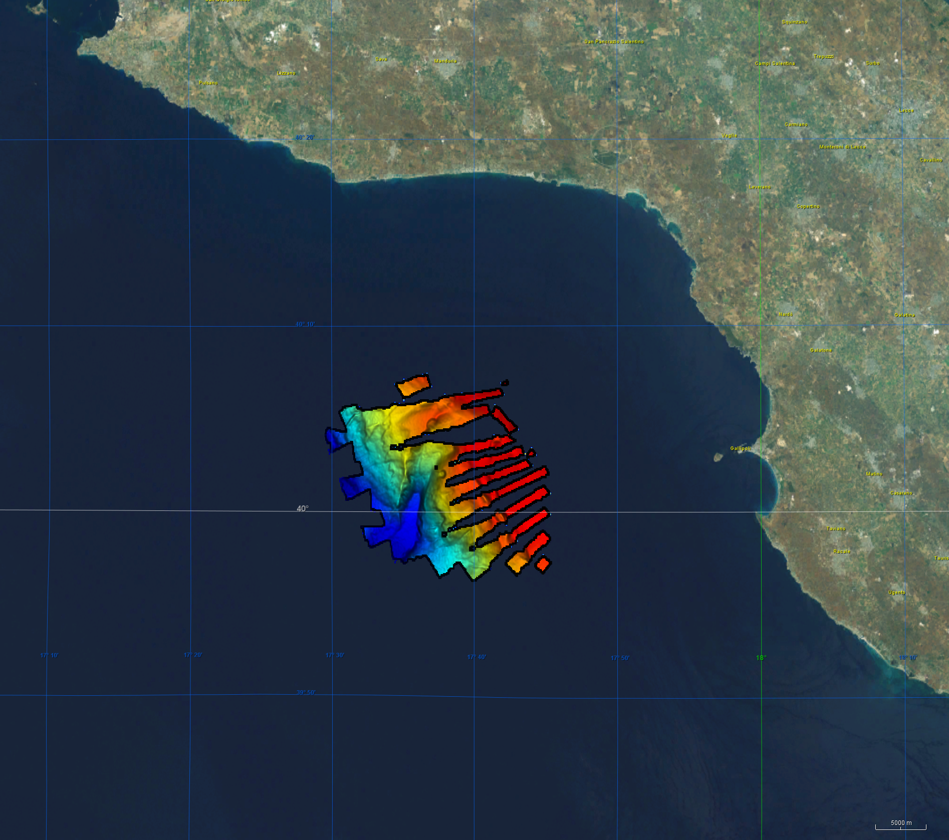
Bathymetric Data, EM122 AOI (Mediterranean, M144-1)
Bathymetry data was acquired during R/V Meteor cruise M144/1 in the aegean region of the Mediterranean Sea between 27.12.2017 and 18.01.2018. The cruise aimed to clarify the causal links between climate and ecosystem change on the one hand by sociocultural evolution on the other hand by climatic and environmental change that can be aligned with the archeological record. CI Citation: Paul Wintersteller ( seafloor-imaging@marum.de) as responsible party for bathymetry raw data ingest and approval. Description of data source: During the M144/1 cruise, the hull-mounted KONGSBERG EM122 multibeam ecosounder (MBES) was utilized to perform bathymetric mapping in medium to deep waters. Two linear transducer arrays in a Mills Cross configuration transmit acoustic signals of a nominal sonar frequency of 12 kHz. With 432 soundings per swath, the emission cone has a dimension of max 150° across track and 1° along track. With a reception obtained from 288 beams, the actual beam footprint is 1° by 2°. Depending on the roughness of the seafloor and the water depth, the swath width on a flat bottom is maximum six times the water depth. For further information on the system, consult https://www.km.kongsberg.com/. The position and depth of the water column is estimated for each beam by using the detected two-way-travel time and the beam angle, ray-traced through the water column, utilizing a proper sound speed profile. Throughout this cruise the swath width was mainly at 120° and did not exceed 130°. Responsible person during this cruise / PI: unstated .
Simple
- Alternate title
-
EMODNET-IFR-WESTMED-2012
- Date (Creation)
- 2019-12-16
- Date (Revision)
- 2020-12-07
- Citation identifier
- 1568_2017_M144-1_EM122_Mediterranean
- Point of contact
-
Organisation name Individual name Electronic mail address Role GEOMAR Helmholtz Centre for Ocean Research Kiel
Originator PANGAEA - Data Publisher for Earth & Environmental Science
Custodian
-
SeaDataNet device categories
-
-
multi-beam echosounders
-
-
Parameter Discovery Vocabulary (P02)
-
-
Bathymetry and Elevation
-
-
GEMET - INSPIRE themes, version 1.0
-
-
Hydrography
-
- Access constraints
- Creative Commons Attribution 4.0 International
- Use constraints
- Other restrictions
- Other constraints
-
DO NOT USE FOR NAVIGATION
- Spatial representation type
- Grid
- Denominator
- 5000
- Distance
- 15 meter
- Language
- English
- Character set
- UTF8
- Topic category
-
- Oceans
- Begin date
- 2018-01-14
- End date
- 2018-01-16 After
))
- Geographic identifier
- http://vocab.nerc.ac.uk/collection/C19/current/3_1_2_4/
- Description
-
Map projection parameters, values and units :
Axes units :
- Codespace
-
EPSG
- Version
-
7.4
- Reference system identifier
- EPSG / WGS 84 (EPSG:4326) / 7.4
- Number of dimensions
- 3
- Dimension name
- Column
- Dimension size
- 3
- Dimension name
- Row
- Dimension size
- 147481653
- Dimension name
- Time
- Dimension size
- 1
- Resolution
- 10 year
- Cell geometry
- Point
- Transformation parameter availability
- No
- Checkpoint Availability
- No
- Point in Pixel
-
- Center
- Distribution format
-
Name Version XYZ Ascii
- Distributor contact
-
Organisation name Individual name Electronic mail address Role PANGAEA - Data Publisher for Earth & Environmental Science
Distributor
- Transfer size
- 662.9
- OnLine resource
-
Protocol Linkage Name WWW:LINK
https://doi.pangaea.de/10.1594/PANGAEA.887862 PANGAEA
WWW:LINK
https://doi.pangaea.de/10.1594/PANGAEA.913074 PANGAEA
WWW:DOWNLOAD
https://downloads.emodnet-bathymetry.eu/high_resolution/3234_1568_2017_M144-1_EM122_Mediterranean.emo.zip WWW:LINK
https://tiles.emodnet-bathymetry.eu/ EMODnet Bathymetry WMTS service
WWW:LINK
https://emodnet.ec.europa.eu/geoviewer/ EMODnet viewer
- Hierarchy level
- Dataset
Vertical extent
- Minimum value
- 186.28
- Maximum value
- 1070.74
Vertical CS
Vertical datum
- Statement
-
no information
- Hierarchy level
- Feature
- Dataset
-
accuracy
Gridded data positional accuracy
- Name of measure
-
horizontal accuracy
- Measure identification
- horizontal accuracy of coordinate
- Measure description
-
Kongsberg SeaTex AS - Seapath 320
- Evaluation method description
-
Estimation based on positioning system of the vessel
Quantitative result
- Value type
- horizontal accuracy
- Value
- 3
Quantitative attribute accuracy
- Name of measure
-
depth
- Measure identification
- depth accuracy
- Measure description
-
Multibeam 12 kHz system, Kongsberg EM122
- Evaluation method description
-
Visual quality evaluation
Quantitative result
- Value
- not defined
Conformance result
- Title
-
Shoal bias
- Date
- Explanation
-
Offset up to 2 m
- Pass
- Yes
- Hierarchy level
- Software
- Other
-
software
- Hierarchy level
- Property type
- Description
-
parameters of data processing
Attributes
- Statement
-
Description of data processing : EMODnet processing methodology using Globe software
- Description
-
Description of processed data sources : Postprocessing and products were conducted by the Seafloor-Imaging & Mapping group of MARUM/FB5, responsible person Paul Wintersteller ( seafloor-imaging@marum.de). The open source software MB-System (Caress, D. W., and D. N. Chayes, MB-System: Mapping the Seafloor, https://www.mbari.org/products/research-software/mb-system, 2017) was utilized for this purpose. Tide and a sound velocity profile were applied to the M144/1 data; there were no corrections for roll, pitch and heave applied. Using Mbeditviz, artefacts were cleaned manually. NetCDF (GMT) grids of the edited data as well as statistics were created with mbgrid. The published bathymetric EM122 grid of the cruise M144/1 has a resolution of 35 m. No total propagated uncertainty (TPU) has been calculated to gather vertical or horizontal accuracy. A higher resolution is, at least partly, achievable. The grid extended with _num represents a raster dataset with the statistical number of beams/depths taken into account to create the depth of the cell. The extended _sd -grid contains the standard deviation for each cell. The DTMs projections are given in Geographic coordinate system Lat/Lon; Geodetic Datum: WGS84. All grids produced are retrievable through the PANGAEA database (www.pangaea.de). The
- Hierarchy level
- Dataset
Absolute external positional accuracy
- Name of measure
-
emodnet-bathymetry.QI.Horizontal
- Value
- 3 - < 20 m
Absolute external positional accuracy
- Name of measure
-
emodnet-bathymetry.QI.Vertical
- Value
- 2 - MBES low frequency (lower than 100kHz) (similar than 1+2%d)
Domain consistency
- Name of measure
-
emodnet-bathymetry.QI.Purpose
- Value
- 2 - Bathymetric/morphologic survey
Metadata
- File identifier
- SDN_CPRD_3234_1568_2017_M144-1_EM122_Mediterranean XML
- Metadata language
- English
- Character set
- UTF8
- Hierarchy level name
-
Product record
- Date stamp
- 2025-04-14T11:44:04.648543Z
- Metadata standard name
-
ISO 19115:2003/19139 - EMODNET - BATHYMETRY
- Metadata standard version
-
1.0
- Metadata author
-
Organisation name Individual name Electronic mail address Role Marum - Center for Marine Environmental Sciences, University of Bremen
Author
)))
