 EMODnet product catalogue
3289_ESTUNLAR_Tangafjordur_A_2015
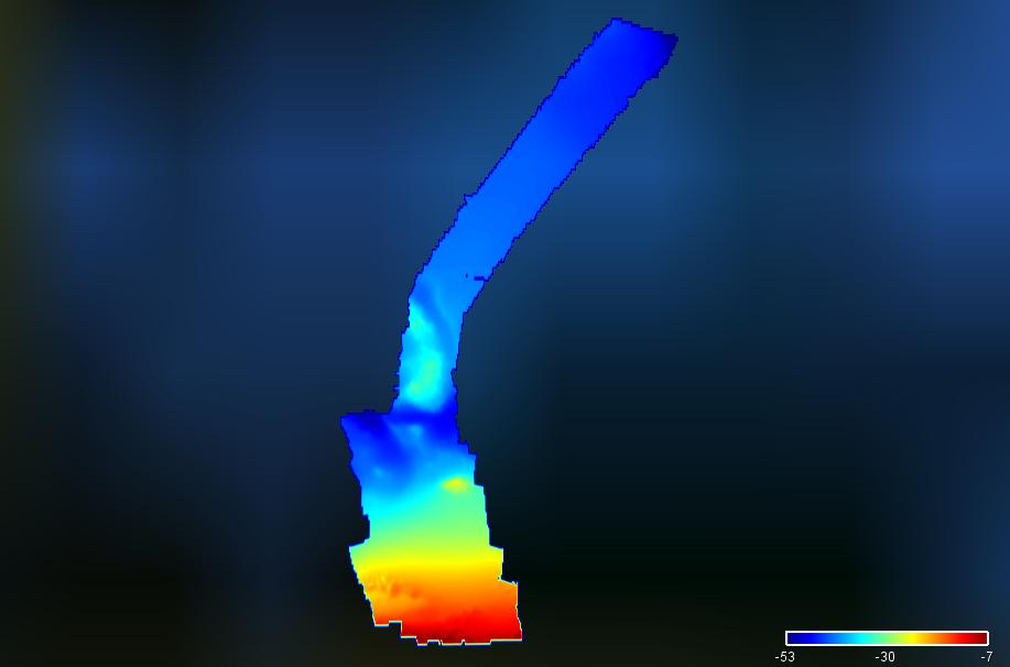
Multibeam bathymetry in Tangafjørður, Faroe Islands.
Simple
- Date (Creation)
- 2015-05-11
- Date (Revision)
- 2015-05-11
- Citation identifier
- FO_ESTTFA_2015
- Point of contact
-
Organisation name Individual name Electronic mail address Role Jardfeingi, the Faroe Islands Earth and Energy Directorate
Originator Jardfeingi, the Faroe Islands Earth and Energy Directorate
Custodian
-
Parameter Discovery Vocabulary (P02)
-
-
Bathymetry and Elevation
-
-
SeaDataNet device categories
-
-
multi-beam echosounders
-
-
Positioning devices
-
-
Differential Global Positioning System receivers
-
-
Vertical Datum
-
-
local reference plane
-
-
Project name
-
-
EMODnet HRSM
-
-
Thèmes Sextant
-
-
/Physical Environment/Bathymetry/Digital Terrain Model
-
- Access constraints
- Creative Commons Attribution 4.0 International
- Use constraints
- Other restrictions
- Other constraints
-
DO NOT USE FOR NAVIGATION
- Spatial representation type
- Grid
- Denominator
- 5000
- Distance
- 0.00390625 Arc minute
- Language
- English
- Character set
- UTF8
- Topic category
-
- Oceans
- Begin date
- 2015-05-11
- End date
- 2015-05-11
Vertical extent
- Minimum value
- 6.58
- Maximum value
- 52.94
- Description
-
Tangafjørður
))
- Number of dimensions
- 3
- Dimension name
- Column
- Dimension size
- 512
- Dimension name
- Row
- Dimension size
- 256
- Dimension name
- Time
- Dimension size
- 1
- Cell geometry
- Point
- Transformation parameter availability
- No
- Checkpoint Availability
- No
- Point in Pixel
-
- Center
- Distribution format
-
Name Version XYZ Ascii
1.0
- Transfer size
- 9
- OnLine resource
-
Protocol Linkage Name WWW:DOWNLOAD
https://downloads.emodnet-bathymetry.eu/high_resolution/3289_FO_ESTTFA_2015.emo.zip WWW:LINK
https://tiles.emodnet-bathymetry.eu/ EMODnet Bathymetry WMTS service
WWW:LINK
https://emodnet.ec.europa.eu/geoviewer EMODnet viewer
- Hierarchy level
- Dataset
Conformance result
- Title
-
Shoal bias
- Date
- Pass
- No
Quantitative attribute accuracy
- Name of measure
-
depth
- Measure identification
- depth accuracy
Quantitative result
- Value
- not defined
Gridded data positional accuracy
- Name of measure
-
horizontal accuracy
- Measure identification
- horizontal accuracy of coordinate
Quantitative result
- Value type
- horizontal accuracy
Absolute external positional accuracy
- Name of measure
-
emodnet-bathymetry.QI.Horizontal
- Value
- 3 - < 20 m
Absolute external positional accuracy
- Name of measure
-
emodnet-bathymetry.QI.Vertical
- Value
- 4 - MBES High frequency (higher that 100kHz) (1+0.5%d)
Domain consistency
- Name of measure
-
emodnet-bathymetry.QI.Purpose
- Value
- 2 - Bathymetric/morphologic survey
- Hierarchy level
- Software
- Other
-
software
- Hierarchy level
- Property type
- Description
-
parameters of data processing
Metadata
- File identifier
- SDN_CPRD_3289_FO_ESTTFA_2015 XML
- Metadata language
- English
- Character set
- UTF8
- Hierarchy level name
-
Composite Product Record
- Date stamp
- 2025-03-07T14:09:17.553075Z
- Metadata standard name
-
ISO 19115:2003/19139 - EMODNET - BATHYMETRY
- Metadata standard version
-
1.0
)))
