 EMODnet product catalogue
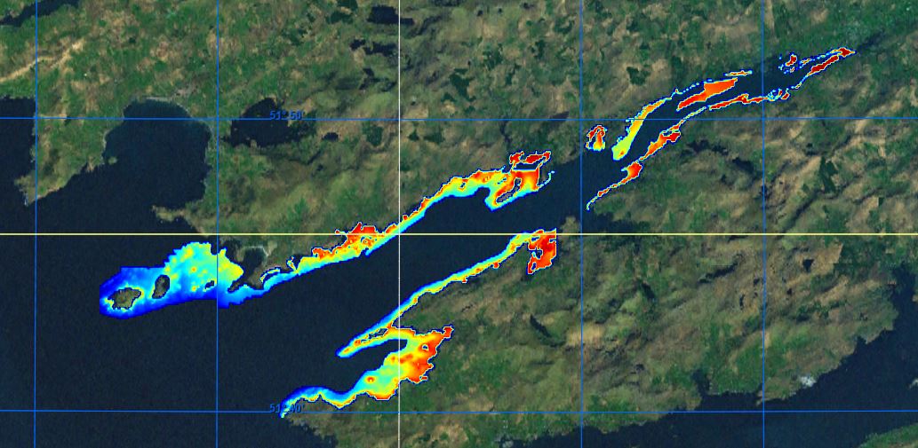
Kenmare Estuary 2021 Surveys
This composite Digital Terrain Model (cDTM) is a high resolution bathymetry dataset highlighting measurement of depth of water in the ocean. This cDTM covers the Kenmare Estuary off the coast of Co. Kerry in Ireland. The EMODnet high resolution DTM covers bathymetry surveys completed between during 2022. Bathymetric data collected on board research vessels using multi-beam and single-beam echosounder instrumentation. Raw bathymetry processed within CARIS software to produce bathymetry products subsequently converted to NetCDF cDTM for EMODnet. Acquisition, processing and product delivery follows IHO standard s44 Edition 5. cDTM is composed of four (4) images “merged simply” using GLOBE software. INFOMAR (Integrated Mapping for the Sustainable Development of Ireland's Marine Resource) is a twenty year program to map the physical, chemical and biological features of Ireland's seabed established in 2006. INFOMAR is funded by the Department of Communications, Climate Action and Environment (DCCAE), and delivered by joint management partners Geological Survey Ireland and the Marine Institute. The program is the successor to the Irish National Seabed Survey (INSS) which ran between 1999 and 2005. INFOMAR concentrates on creating integrated mapping products related to the seabed.
Simple
- Date (Creation)
- 2022-09-26
- Date (Revision)
- 2022-10-06
- Citation identifier
- HRDTM_14m_Kenmare_2021_WGS84
- Point of contact
-
Organisation name Individual name Electronic mail address Role Geological Survey Ireland
Originator Geological Survey Ireland
Custodian
-
Project name
-
-
EMODNet Bathymetry
-
-
SeaDataNet device categories
-
-
multi-beam echosounders
-
-
Parameter Discovery Vocabulary (P02)
-
-
Bathymetry and Elevation
-
-
GEMET - INSPIRE themes, version 1.0
-
-
Hydrography
-
-
SeaDataNet depth measurement reference planes
-
-
Malin Ordnance Datum
-
- Access constraints
- Creative Commons Attribution 4.0 International
- Use constraints
- Other restrictions
- Other constraints
-
DO NOT USE FOR NAVIGATION
- Use limitation
-
maritime navigation; maritime spatial planning, renewable energy
- Spatial representation type
- Grid
- Denominator
- 100000
- Distance
- 14 Metres (m)
- Language
- English
- Character set
- UTF8
- Topic category
-
- Oceans
- Begin date
- 2020-07-02
- End date
- 2021-08-10
))
- Geographic identifier
- Kenmare Estuary
- Description
-
Map projection parameters, values and units :
Axes units :
- Codespace
-
EPSG
- Version
-
7.4
- Reference system identifier
- EPSG / WGS 84 (EPSG:4326) / 7.4
- Unique resource identifier
- EPSG:5861
- Number of dimensions
- 3
- Dimension name
- Column
- Dimension size
- 5325
- Dimension name
- Row
- Dimension size
- 1617
- Dimension name
- Time
- Dimension size
- 1
- Cell geometry
- Point
- Transformation parameter availability
- No
- Checkpoint Availability
- No
- Point in Pixel
-
- Lower left
- Distribution format
-
Name Version NetCDF
4.0
- Distributor contact
-
Organisation name Individual name Electronic mail address Role Geological Survey Ireland
Distributor
- Transfer size
- 131
- OnLine resource
-
Protocol Linkage Name WWW:LINK
https://tiles.emodnet-bathymetry.eu/ EMODnet Bathymetry WMTS service
WWW:LINK
https://emodnet.ec.europa.eu/geoviewer EMODnet viewer
WWW:DOWNLOAD
https://downloads.emodnet-bathymetry.eu/high_resolution/366_HRDTM_14m_Kenmare_2021_WGS84.emo.zip
- Hierarchy level
- Dataset
Vertical extent
- Minimum value
- -1.88
- Maximum value
- 62.51
Vertical CS
Vertical datum
- Statement
-
no information
- Hierarchy level
- Feature
- Dataset
-
accuracy
Gridded data positional accuracy
- Name of measure
-
horizontal accuracy
- Measure identification
- horizontal accuracy of coordinate
- Measure description
-
Total Horizontal Uncertainty (THU)
- Evaluation method description
-
Component of total propagated uncertainty (TPU) calculated in the horizontal dimension. THU is a two-dimensional quantity with all contributing horizontal measurement uncertainties included.
Quantitative result
- Value type
- horizontal accuracy
- Value
- International Hydrographic Organization Standards for Hydrographic Surveys
Quantitative attribute accuracy
- Name of measure
-
depth
- Measure identification
- depth accuracy
- Measure description
-
Total Vertical Uncertainty (TVU)
- Evaluation method description
-
Component of total propagated uncertainty (TPU) calculated in the vertical dimension. TVU is a one-dimensional quantity with all contributing vertical measurement uncertainties included.
Quantitative result
- Value
- not defined
Conformance result
- Title
-
Shoal bias
- Date
- Hierarchy level
- Software
- Other
-
software
- Hierarchy level
- Property type
- Description
-
parameters of data processing
Attributes
- Statement
-
Convert 5m XYZ to 14m DTM using GLOBE. Merge simple DTM's using GLOBE.
- Description
-
BY_GEO20_01_Castletownbere_14m_WGS84.dtm.nc
BY_GEO21_01_Kenmare_14m_WGS84.dtm.nc
BY_GEO21_03_Kenmare_14m_WGS84.dtm.nc
BY_LIR21_03_Kenmare_14m_WGS84.dtm.nc
- Hierarchy level
- Dataset
Absolute external positional accuracy
- Name of measure
-
emodnet-bathymetry.QI.Horizontal
- Value
- 3 - < 20 m
Absolute external positional accuracy
- Name of measure
-
emodnet-bathymetry.QI.Vertical
- Value
- 4 - MBES High frequency (higher that 100kHz) (1+0.5%d)
Domain consistency
- Name of measure
-
emodnet-bathymetry.QI.Purpose
- Value
- 3 - Hydrographic survey or compatible with hydrographic standards
Metadata
- File identifier
- SDN_CPRD_366_HRDTM_14m_Kenmare_2021_WGS84 XML
- Metadata language
- English
- Character set
- UTF8
- Hierarchy level name
-
Product record
- Date stamp
- 2023-01-26T15:23:15.82Z
- Metadata standard name
-
ISO 19115:2003/19139 - EMODNET - BATHYMETRY
- Metadata standard version
-
1.0
- Metadata author
-
Organisation name Individual name Electronic mail address Role Geological Survey Ireland
Author
)))
