 EMODnet product catalogue
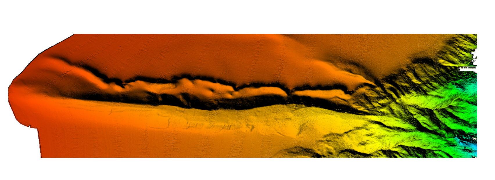
4036 HRDTM 1/128 Depression Cumecs
The data were acquired with a Simrad EM710 Multi Beam echosounder onboard the R/V Urania in order to cover the outer Malta Plateau and upper Malta Escarpment for a geological survey in the framework of EU FP7 project EUROFLEETS. The data were published in: Micallef, A., Georgiopoulou, A., Le Bas, T., Mountjoy, J.J., Huvenne, V., Lo Iacono, C., 2013. The Malta-Sicily Escarpment: Mass Movement dynamics in a sediment-undersupplied margin, in: Krastel, S., Berhmann, J.H., Volker, D., Stipp, M., Berndt, C., Urgeles, R., Chaytor, J.D., Huhn, K., Strasser, M., Harbitz, C.B. (Eds.), Submarine Mass Movements and Their Consequences. Springer International Publishing, Switzerland, pp. 317-328.
Simple
- Alternate title
-
KN172L08 SeaBeam 3012-P1 Bathymetry Grid
- Date (Creation)
- Invalid DateT00:00:00
- Date (Revision)
- Invalid DateT00:00:00
- Citation identifier
- CUMECS_Depression_Cumecs
- Point of contact
-
Organisation name Individual name Electronic mail address Role Marine Geology and Seafloor Surveying group, Department of Geosciences, University of Malta
Originator Marine Geology and Seafloor Surveying group, Department of Geosciences, University of Malta
Custodian
-
Project name
-
-
EMODNet Bathymetry
-
-
SeaDataNet device categories
-
-
multi-beam echosounders
-
multi-beam echosounders
-
-
SeaDataNet device categories
-
-
Differential Global Positioning System receivers
-
-
Parameter Discovery Vocabulary (P02)
-
-
Bathymetry and Elevation
-
-
GEMET - INSPIRE themes, version 1.0
-
-
Hydrography
-
- Access constraints
- Creative Commons Attribution 4.0 International
- Use constraints
- Other restrictions
- Other constraints
-
DO NOT USE FOR NAVIGATION
- Spatial representation type
- Grid
- Denominator
- 50000
- Distance
- 0.0078125 Arc minute
- Language
- English
- Character set
- UTF8
- Topic category
-
- Oceans
- Begin date
- 2012-06-28T09:00:00
- End date
- 2012-07-02T09:00:00 After
))
- Description
-
Map projection parameters, values and units :
Axes units :
UPPER LEFT X=29.3054583250
UPPER LEFT Y=44.6262830219
LOWER RIGHT X=40.7816282263
LOWER RIGHT Y=41.2281769950
WEST LONGITUDE=29° 18' 19.6500" E
NORTH LATITUDE=44° 37' 34.6189" N
EAST LONGITUDE=40° 46' 53.8616" E
SOUTH LATITUDE=41° 13' 41.4372" N
PROJ_DESC=Geographic (Latitude/Longitude) / WGS84 / arc degrees
PROJ_DATUM=WGS84
PROJ_UNITS=arc degrees
EPSG_CODE=4326
COVERED AREA=353215 sq km
- Geographic identifier
- EPSG / WGS84 / Geographic coordinate system / 7.4
- Reference system identifier
- EPSG / WGS 84 (EPSG:4326) / 7.4
- Number of dimensions
- 3
- Dimension name
- Column
- Dimension size
- 377
- Dimension name
- Row
- Dimension size
- 1424
- Dimension name
- Time
- Dimension size
- 1
- Cell geometry
- Point
- Transformation parameter availability
- No
- Checkpoint Availability
- No
- Point in Pixel
-
- Center
- Distribution format
-
Name Version XYZ Ascii
- Distributor contact
-
Organisation name Individual name Electronic mail address Role Marine Geology and Seafloor Surveying group, Department of Geosciences, University of Malta
Distributor
- Transfer size
- 38.7
- OnLine resource
-
Protocol Linkage Name WWW:DOWNLOAD
https://downloads.emodnet-bathymetry.eu/high_resolution/4036_CUMECS_Depression_Cumecs.emo.zip WWW:LINK
https://tiles.emodnet-bathymetry.eu/ EMODnet Bathymetry WMTS service
WWW:LINK
https://emodnet.ec.europa.eu/geoviewer EMODnet viewer
- Hierarchy level
- Dataset
Vertical extent
- Minimum value
- 100
- Maximum value
- 1289
Vertical CS
Vertical datum
- Statement
-
no information
- Hierarchy level
- Feature
- Dataset
-
accuracy
Gridded data positional accuracy
- Name of measure
-
horizontal accuracy
- Measure identification
- horizontal accuracy of coordinate
Quantitative result
- Value type
- horizontal accuracy
Quantitative attribute accuracy
- Name of measure
-
depth
- Measure identification
- depth accuracy
Quantitative result
- Value
- not defined
Conformance result
- Title
-
Shoal bias
- Date
- Hierarchy level
- Software
- Description
-
MB-System
- Other
-
software
- Hierarchy level
- Property type
- Description
-
parameters of data processing
Attributes
- Statement
-
EMODnet processing methodology using Globe software
- Description
-
4036_CUMECS
- Hierarchy level
- Dataset
Absolute external positional accuracy
- Name of measure
-
emodnet-bathymetry.QI.Horizontal
- Value
- 3 - < 20 m
Absolute external positional accuracy
- Name of measure
-
emodnet-bathymetry.QI.Vertical
- Value
- 4 - MBES High frequency (higher that 100kHz) (1+0.5%d)
Domain consistency
- Name of measure
-
emodnet-bathymetry.QI.Purpose
- Value
- 2 - Bathymetric/morphologic survey
Metadata
- File identifier
- SDN_CPRD_4036_CUMECS_Depression_Cumecs XML
- Metadata language
- English
- Character set
- UTF8
- Hierarchy level name
-
Composite Product Record
- Date stamp
- 2022-09-21T06:54:56.784Z
- Metadata standard name
-
ISO 19115:2003/19139 - EMODNET - BATHYMETRY
- Metadata standard version
-
1.0
- Metadata author
-
Organisation name Individual name Electronic mail address Role Marine Geology and Seafloor Surveying group, Department of Geosciences, University of Malta
Author
)))
