 EMODnet product catalogue
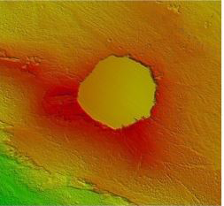
4036 HRDTM 1/128 Sinkhole (Offshore of Malta)
The data were acquired with a Simrad EM3002-D Multi Beam echosounder onboard the R/V Hercules as part of a habitat mapping survey in the framework of RICS funded project. The data were published in: Micallef, A., Le Bas, T.P., Huvenne, V.A.I., Blondel, P., Hühnerbach, V., Deidun, A., 2012. A multi-method approach for benthic habitat mapping of shallow coastal areas with high resolution multibeam data. Continental Shelf Research 39-40, 14-26.
Simple
- Date (Creation)
- Date (Revision)
- Citation identifier
- RICS_Sinkholes
- Point of contact
-
Organisation name Individual name Electronic mail address Role Marine Geology and Seafloor Surveying group, Department of Geosciences, University of Malta
Originator Marine Geology and Seafloor Surveying group, Department of Geosciences, University of Malta
Originator Marine Geology and Seafloor Surveying group, Department of Geosciences, University of Malta
Custodian
-
Parameter Discovery Vocabulary (P02)
-
-
Bathymetry and Elevation
-
-
SeaDataNet device categories
-
-
multi-beam echosounders
-
-
Positioning devices
-
-
Differential Global Positioning System receivers
-
-
Vertical Datum
-
-
Lowest Astronomical Tide
-
-
Project name
-
-
EMODnet HRSM
-
-
Thèmes Sextant
-
-
/Physical Environment/Bathymetry/Digital Terrain Model
-
- Access constraints
- Creative Commons Attribution 4.0 International
- Use constraints
- Other restrictions
- Other constraints
-
DO NOT USE FOR NAVIGATION
- Spatial representation type
- Grid
- Denominator
- 5000
- Distance
- 0.0078125 Arc minute
- Language
- English
- Character set
- UTF8
- Topic category
-
- Oceans
- Begin date
- 2010-04-26
- End date
- 2010-04-30
Vertical extent
- Minimum value
- 12
- Maximum value
- 43
))
- Reference system identifier
- EPSG / WGS 84 (EPSG:4326) / 7.4
- Number of dimensions
- 3
- Dimension name
- Column
- Dimension size
- 256
- Dimension name
- Row
- Dimension size
- 256
- Dimension name
- Time
- Dimension size
- 1
- Cell geometry
- Point
- Transformation parameter availability
- No
- Checkpoint Availability
- No
- Point in Pixel
-
- Distribution format
-
Name Version NetCDF
- Transfer size
- 1
- OnLine resource
-
Protocol Linkage Name WWW:LINK
https://emodnet.ec.europa.eu/geoviewer/ EMDOnet viewer
WWW:DOWNLOAD
https://downloads.emodnet-bathymetry.eu/high_resolution/4036_RICS_Sinkholes.emo.zip WWW:LINK
https://tiles.emodnet-bathymetry.eu/ EMODnet Bathymetry WMTS service
- Hierarchy level
- Dataset
Conformance result
- Title
-
Shoal bias
- Date
- Pass
- No
Quantitative attribute accuracy
- Name of measure
-
depth
- Measure identification
- depth accuracy
Quantitative result
- Value
- not defined
Gridded data positional accuracy
- Name of measure
-
horizontal accuracy
- Measure identification
- horizontal accuracy of coordinate
Quantitative result
- Value type
- horizontal accuracy
Absolute external positional accuracy
- Name of measure
-
emodnet-bathymetry.QI.Horizontal
- Value
- 3 - < 20 m
Absolute external positional accuracy
- Name of measure
-
emodnet-bathymetry.QI.Vertical
- Value
- 4 - MBES High frequency (higher that 100kHz) (1+0.5%d)
Domain consistency
- Name of measure
-
emodnet-bathymetry.QI.Purpose
- Value
- 2 - Bathymetric/morphologic survey
- Hierarchy level
- Software
- Other
-
software
- Hierarchy level
- Property type
- Description
-
parameters of data processing
- Statement
-
EMODnet processing methodology using Globe software
- Description
-
4036_RICS
Metadata
- File identifier
- SDN_CPRD_4036_RICS_Sinkholes XML
- Metadata language
- English
- Character set
- UTF8
- Hierarchy level name
-
Composite Product Record
- Date stamp
- 2022-07-19T08:43:26.351Z
- Metadata standard name
-
ISO 19115:2003/19139 - EMODNET - BATHYMETRY
- Metadata standard version
-
1.0
)))
