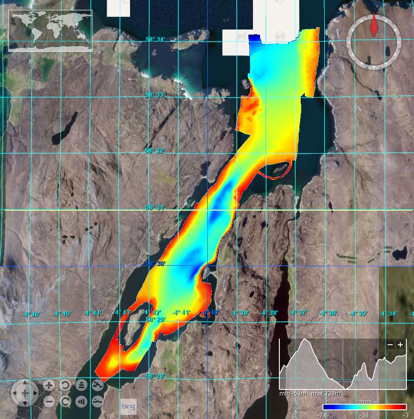
2010/6: Loch Eriboll: 1/128
This British Geological Survey (BGS) marine multibeam survey took place in August 2010 in Loch Eriboll on board the RV White Ribbon. The aim was improve the geological understanding of the area and the interpretation of various sedimentary processes active on the seafloor. Loch Eriboll has played an important role in naval warfare and it is believed much material, including several vessels, has ended up on the floor of the loch. Having an accurate map of such obstacles can be used to update the archaeological records and mean better marine spatial planning for future users including aquaculture. Sea floor bathymetry data were collected using a Kongsberg EM3002D multibeam system.
owner
: {{md.getOwnername()}}
{{'mdStatusRecord' | translate}}: {{('mdStatus-' + md.mdStatus) | translate}}
| Date |
2017-12-07
|
| Date type |
Creation:
Date identifies when the resource was brought into existence
|
| Date type |
Revision:
Date identifies when the resource was examined or re-examined and improved or
amended
|
| Unique resource identifier |
BGS_2010_6_LochEriboll |
| Organisation name |
British Geological Survey, Edinburgh |
| Delivery point |
The Lyell Centre |
| City |
Edinburgh |
| Postal code |
EH14 4AP |
| Country |
United Kingdom |
| Electronic mail address |
OffshoreData@bgs.ac.uk
|
| Linkage |
http://www.bgs.ac.uk/
|
| Role |
Originator:
Party who created the resource
|
| Organisation name |
British Geological Survey, Edinburgh |
| Delivery point |
The Lyell Centre |
| City |
Edinburgh |
| Postal code |
EH14 4AP |
| Country |
United Kingdom |
| Electronic mail address |
OffshoreData@bgs.ac.uk
|
| Linkage |
http://www.bgs.ac.uk/
|
| Role |
Custodian:
Party that accepts accountability and responsability for the data and ensures
appropriate care and maintenance of the resource
|
| Parameter Discovery Vocabulary (P02) |
Bathymetry and Elevation
|
| SeaDataNet device categories |
multi-beam echosounders
|
| Positioning devices |
Differential Global Positioning System receivers
|
| Vertical Datum |
UK Admiralty Chart Datum
|
| Project name |
EMODnet HRSM
|
| Thèmes Sextant |
/Physical Environment/Bathymetry/Digital Terrain Model
|
| GDI-Vlaanderen Trefwoorden |
Metadata GDI-Vl-conform
|
| Spatial representation type |
Grid:
Grid data is used to represent geographic data
|
| Distance |
0.0078125 Arc minute |
| Language |
English |
| Character set |
UTF8:
8-bit variable size UCS Transfer Format, based on ISO/IEC 10646
|
| Topic category code |
|
| Unique resource identifier |
WGS 84 / UTM zone 30N (EPSG:32630) |
| Codespace |
EPSG |
| Hierarchy level |
Dataset:
Information applies to the dataset
|
| Hierarchy level |
Software:
Information applies to a computer program or routine
|
| Hierarchy level |
Property type:
Information applies to a property type
|
| Other |
software |
| Record |
4 - MBES High frequency (higher that 100kHz) (1+0.5%d) |
|
| Statement |
EMODnet processing methodology using Globe software |
| Access constraints |
Creative Commons Attribution 4.0 International:
Creative Commons Attribution 4.0 International
|
| Use constraints |
Other restrictions:
Limitation not listed
|
| Other constraints |
DO NOT USE FOR NAVIGATION |
|
|
|
| Organisation name |
British Geological Survey, Edinburgh |
| Delivery point |
The Lyell Centre |
| City |
Edinburgh |
| Postal code |
EH14 4AP |
| Country |
United Kingdom |
| Electronic mail address |
OffshoreData@bgs.ac.uk
|
| Linkage |
http://www.bgs.ac.uk/
|
| Role |
Distributor:
Party who distributes the resource
|
|
|
|
 EMODnet Product Catalogue
}})