 EMODnet product catalogue
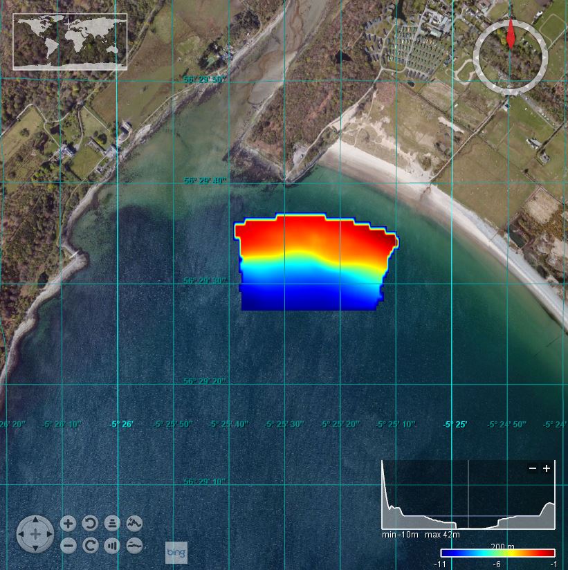
2012/5 QICS: Ardmucknish Bay: 1/128
This British Geological Survey (BGS) marine geophysical and multibeam survey took place in June 2012 in the area of Ardmucknish Bay on board the RV White Ribbon. This was a follow up survey to the previous work carried out in this area (2011/4 and 2012/5). QICS (Quantifying and monitoring potential ecosystem impacts of geological carbon storage) was a scientific research project funded by NERC; its purpose was to improve the understanding of the sensitivities of the UK marine environment to a potential leak from a carbon capture storage (CCS) system. Sea floor bathymetry data were collected using a Kongsberg EM3002D multibeam system.
Simple
- Date (Creation)
- 2017-12-07
- Date (Revision)
- Citation identifier
- BGS_2012_5_ArdmucknishBay
- Point of contact
-
Organisation name Individual name Electronic mail address Role British Geological Survey, Edinburgh
Originator British Geological Survey, Edinburgh
Custodian
-
Parameter Discovery Vocabulary (P02)
-
-
Bathymetry and Elevation
-
-
SeaDataNet device categories
-
-
multi-beam echosounders
-
-
Positioning devices
-
-
Differential Global Positioning System receivers
-
-
Vertical Datum
-
-
UK Admiralty Chart Datum
-
-
Project name
-
-
EMODnet HRSM
-
-
Thèmes Sextant
-
-
/Physical Environment/Bathymetry/Digital Terrain Model
-
- Access constraints
- Creative Commons Attribution 4.0 International
- Use constraints
- Other restrictions
- Other constraints
-
DO NOT USE FOR NAVIGATION
- Spatial representation type
- Grid
- Denominator
- 50000
- Distance
- 0.0078125 Arc minute
- Language
- English
- Character set
- UTF8
- Topic category
-
- Oceans
- Begin date
- 2012-04-11
- End date
- 2012-04-13
Vertical extent
- Minimum value
- 0
- Maximum value
- 12
))
- Reference system identifier
- EPSG / WGS 84 / UTM zone 30N (EPSG:32630) / 8.6
- Number of dimensions
- 3
- Dimension name
- Column
- Dimension size
- 128
- Dimension name
- Row
- Dimension size
- 128
- Dimension name
- Time
- Dimension size
- 1
- Cell geometry
- Point
- Transformation parameter availability
- No
- Checkpoint Availability
- No
- Point in Pixel
-
- Lower left
- Distributor contact
-
Organisation name Individual name Electronic mail address Role British Geological Survey, Edinburgh
Distributor
- OnLine resource
-
Protocol Linkage Name WWW:LINK
https://emodnet.ec.europa.eu/geoviewer/ EMODnet viewer
WWW:DOWNLOAD
https://downloads.emodnet-bathymetry.eu/high_resolution/42_BGS_2012_5_ArdmucknishBay.emo.zip WWW:LINK
https://tiles.emodnet-bathymetry.eu/ EMODnet Bathymetry WMTS service
- Hierarchy level
- Dataset
Conformance result
- Title
-
Shoal bias
- Date
- Pass
- No
Quantitative attribute accuracy
- Name of measure
-
depth
- Measure identification
- depth accuracy
- Measure description
-
0.1 metres
Quantitative result
- Value
- not defined
Gridded data positional accuracy
- Name of measure
-
horizontal accuracy
- Measure identification
- horizontal accuracy of coordinate
- Measure description
-
0.1 metres
Quantitative result
- Value type
- horizontal accuracy
Absolute external positional accuracy
- Name of measure
-
emodnet-bathymetry.QI.Horizontal
- Value
- 3 - < 20 m
Absolute external positional accuracy
- Name of measure
-
emodnet-bathymetry.QI.Vertical
- Value
- 4 - MBES High frequency (higher that 100kHz) (1+0.5%d)
Domain consistency
- Name of measure
-
emodnet-bathymetry.QI.Purpose
- Value
- 3 - Hydrographic survey or compatible with hydrographic standards
- Hierarchy level
- Software
- Other
-
software
- Hierarchy level
- Property type
- Description
-
parameters of data processing
- Statement
-
EMODnet processing methodology using Globe software
- Description
-
SDN:CDI:LOCAL:42_2012_5_ArdmucknishBay
Metadata
- File identifier
- SDN_CPRD_42_BGS_2012_5_ArdmucknishBay XML
- Metadata language
- English
- Character set
- UTF8
- Hierarchy level name
-
Composite Product Record
- Date stamp
- 2022-07-18T10:15:20.153Z
- Metadata standard name
-
ISO 19115:2003/19139 - EMODNET - BATHYMETRY
- Metadata standard version
-
1.0
)))
