 EMODnet product catalogue
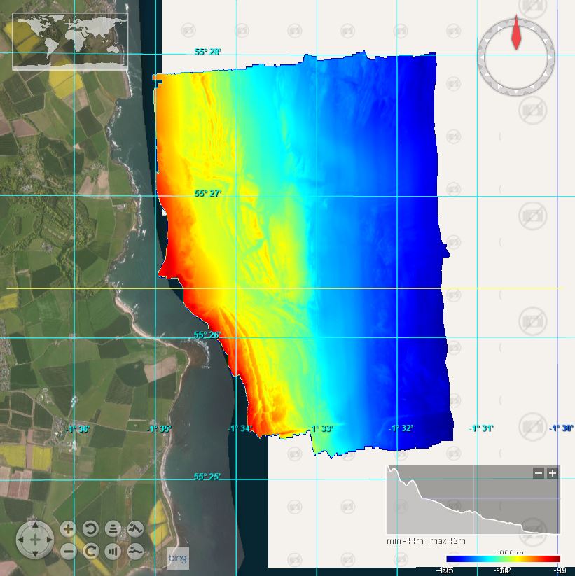
2014/4: East Coast Amble: 1/128
This marine multibeam and geophysical survey took place from 26 September – 5 October 2014 in the area of the North East coast of England near Craster on board the RV White Ribbon. The survey was carried out by British Geological Survey (BGS) in collaboration with English Heritage and Wessex Archaeology. Bathymetric data on MV White Ribbon was acquired using a Kongsberg EM3002D multibeam echosounder system. Kongsberg Seafloor Information System (SIS) version 3.9.2 (build 187) was used for online data logging. A Trimble SPS461 and a Kongsberg Seatex Seapath 200 provided vessel position, heading and attitude. Offline data processing was performed using CARIS HIPS version 8.1.5.
Simple
- Date (Creation)
- 2017-12-07
- Date (Revision)
- Citation identifier
- BGS_2014_4_EastCoast
- Point of contact
-
Organisation name Individual name Electronic mail address Role British Geological Survey, Edinburgh
Originator British Geological Survey, Edinburgh
Custodian
-
Parameter Discovery Vocabulary (P02)
-
-
Bathymetry and Elevation
-
-
SeaDataNet device categories
-
-
multi-beam echosounders
-
-
Positioning devices
-
-
Differential Global Positioning System receivers
-
-
Vertical Datum
-
-
UK Admiralty Chart Datum
-
-
Project name
-
-
EMODnet HRSM
-
-
Thèmes Sextant
-
-
/Physical Environment/Bathymetry/Digital Terrain Model
-
- Access constraints
- Creative Commons Attribution 4.0 International
- Use constraints
- Other restrictions
- Other constraints
-
DO NOT USE FOR NAVIGATION
- Spatial representation type
- Grid
- Denominator
- 50000
- Distance
- 0.0078125 Arc minute
- Language
- English
- Character set
- UTF8
- Topic category
-
- Oceans
- Begin date
- 2014-08-26
- End date
- 2014-09-05
Vertical extent
- Minimum value
- 2
- Maximum value
- 35
))
- Reference system identifier
- EPSG / WGS 84 / UTM zone 30N (EPSG:32630) / 8.6
- Number of dimensions
- 3
- Dimension name
- Column
- Dimension size
- 640
- Dimension name
- Row
- Dimension size
- 512
- Dimension name
- Time
- Dimension size
- 1
- Cell geometry
- Point
- Transformation parameter availability
- No
- Checkpoint Availability
- No
- Point in Pixel
-
- Lower left
- Distributor contact
-
Organisation name Individual name Electronic mail address Role British Geological Survey, Edinburgh
Distributor
- OnLine resource
-
Protocol Linkage Name WWW:LINK
https://emodnet.ec.europa.eu/geoviewer/ EMODnet viewer
WWW:LINK
https://tiles.emodnet-bathymetry.eu/ EMODnet Bathymetry WMTS service
WWW:DOWNLOAD
https://downloads.emodnet-bathymetry.eu/high_resolution/42_BGS_2014_4_EastCoast.emo.zip
- Hierarchy level
- Dataset
Conformance result
- Title
-
Shoal bias
- Date
- Pass
- No
Quantitative attribute accuracy
- Name of measure
-
depth
- Measure identification
- depth accuracy
- Measure description
-
0.1 metres
Quantitative result
- Value
- not defined
Gridded data positional accuracy
- Name of measure
-
horizontal accuracy
- Measure identification
- horizontal accuracy of coordinate
- Measure description
-
0.1 metres
Quantitative result
- Value type
- horizontal accuracy
Absolute external positional accuracy
- Name of measure
-
emodnet-bathymetry.QI.Horizontal
- Value
- 3 - < 20 m
Absolute external positional accuracy
- Name of measure
-
emodnet-bathymetry.QI.Vertical
- Value
- 4 - MBES High frequency (higher that 100kHz) (1+0.5%d)
Domain consistency
- Name of measure
-
emodnet-bathymetry.QI.Purpose
- Value
- 3 - Hydrographic survey or compatible with hydrographic standards
- Hierarchy level
- Software
- Other
-
software
- Hierarchy level
- Property type
- Description
-
parameters of data processing
- Statement
-
EMODnet processing methodology using Globe software
- Description
-
SDN:CDI:LOCAL:42_2014_4_EastCoast2m
Metadata
- File identifier
- SDN_CPRD_42_BGS_2014_4_EastCoast XML
- Metadata language
- English
- Character set
- UTF8
- Hierarchy level name
-
Composite Product Record
- Date stamp
- 2022-09-22T12:51:42.811Z
- Metadata standard name
-
ISO 19115:2003/19139 - EMODNET - BATHYMETRY
- Metadata standard version
-
1.0
)))
