 EMODnet product catalogue
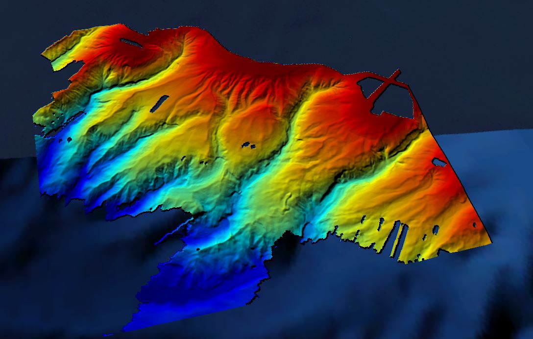
486 HRDTM 1/32 Canyons Bay of Biscay Zone BOB2
Grid processed for the purpose of the HR DTMs layer of EMODnet Bathymetry HRSM, October 2018
Simple
- Date (Creation)
- 2018-10-15T00:00:00
- Date (Revision)
- Citation identifier
- HR_1_32_CANYON_BISCAYBAY_BOB2
- Point of contact
-
Organisation name Individual name Electronic mail address Role IFREMER / GM-MARINE GEOSCIENCES
Originator IFREMER / IDM / SISMER - Scientific Information Systems for the SEA
Custodian
-
Parameter Discovery Vocabulary (P02)
-
-
Bathymetry and Elevation
-
-
SeaDataNet device categories
-
-
multi-beam echosounders
-
-
Positioning devices
-
-
Differential Global Positioning System receivers
-
-
Vertical Datum
-
-
sea level
-
-
Project name
-
-
EMODnet HRSM
-
-
Thèmes Sextant
-
-
/Physical Environment/Bathymetry/Digital Terrain Model
-
- Access constraints
- Creative Commons Attribution 4.0 International
- Use constraints
- Other restrictions
- Other constraints
-
DO NOT USE FOR NAVIGATION
- Spatial representation type
- Grid
- Denominator
- 50000
- Distance
- 0.03125 Arc minute
- Language
- English
- Character set
- UTF8
- Topic category
-
- Oceans
- Begin date
- 2009-07-02T00:00:00
- End date
- 2010-07-15T00:00:00
Vertical extent
- Minimum value
- 172
- Maximum value
- 3770
))
- Reference system identifier
- EPSG / WGS 84 (EPSG:4326) / 7.4
- Number of dimensions
- 3
- Dimension name
- Column
- Dimension size
- 1408
- Dimension name
- Row
- Dimension size
- 960
- Dimension name
- Time
- Dimension size
- 1
- Cell geometry
- Point
- Transformation parameter availability
- No
- Checkpoint Availability
- No
- Point in Pixel
-
- Lower left
- Distribution format
-
Name Version NetCDF
- Transfer size
- 23
- OnLine resource
-
Protocol Linkage Name WWW:LINK
https://emodnet.ec.europa.eu/geoviewer/ EMODnet viewer
WWW:LINK
https://sextant.ifremer.fr/record/44e3e850-5bf3-4d5d-a2b9-d277111f3aae/ WWW:DOWNLOAD
https://downloads.emodnet-bathymetry.eu/high_resolution/486_HR_1_32_CANYON_BISCAYBAY_BOB2.emo.zip WWW:LINK
https://tiles.emodnet-bathymetry.eu/ EMODnet Bathymetry WMTS service
- Hierarchy level
- Dataset
Conformance result
- Title
-
Shoal bias
- Date
- Pass
- No
Quantitative attribute accuracy
- Name of measure
-
depth
- Measure identification
- depth accuracy
Quantitative result
- Value
- not defined
Gridded data positional accuracy
- Name of measure
-
horizontal accuracy
- Measure identification
- horizontal accuracy of coordinate
Quantitative result
- Value type
- horizontal accuracy
Absolute external positional accuracy
- Name of measure
-
emodnet-bathymetry.QI.Horizontal
- Value
- 3 - < 20 m
Absolute external positional accuracy
- Name of measure
-
emodnet-bathymetry.QI.Vertical
- Value
- 2 - MBES low frequency (lower than 100kHz) (similar than 1+2%d)
Domain consistency
- Name of measure
-
emodnet-bathymetry.QI.Purpose
- Value
- 2 - Bathymetric/morphologic survey
- Hierarchy level
- Software
- Other
-
software
- Hierarchy level
- Property type
- Description
-
parameters of data processing
- Statement
-
Globe software, EMODnet Bathymetry guidelines
- Description
-
Multiple multibeam surveys, CDI 135800, 142933, 142935, 142936, 142939, 142937, 142934, 142940, 160658
How to cite ?
BOURILLET Jean-François (2009) BOBGEO cruise, RV Pourquoi pas ?, https://doi.org/10.17600/9030060
BOURILLET Jean-François (2010) BOBGEO2 cruise, RV Le Suroît, https://doi.org/10.17600/10020020
FLOCH Henri, CLEC'H Didier (2009) VALIDOP cruise, RV L'Atalante, https://doi.org/10.17600/9010030
Metadata
- File identifier
- SDN_CPRD_486_HR_1_32_CANYON_BISCAYBAY_BOB2 XML
- Metadata language
- English
- Character set
- UTF8
- Hierarchy level name
-
Composite Product Record
- Date stamp
- 2025-03-07T14:09:35.832928Z
- Metadata standard name
-
ISO 19115:2003/19139 - EMODNET - BATHYMETRY
- Metadata standard version
-
1.0
- Metadata author
-
Organisation name Individual name Electronic mail address Role IFREMER / IDM / SISMER - Scientific Information Systems for the SEA
Author
)))
