 EMODnet product catalogue
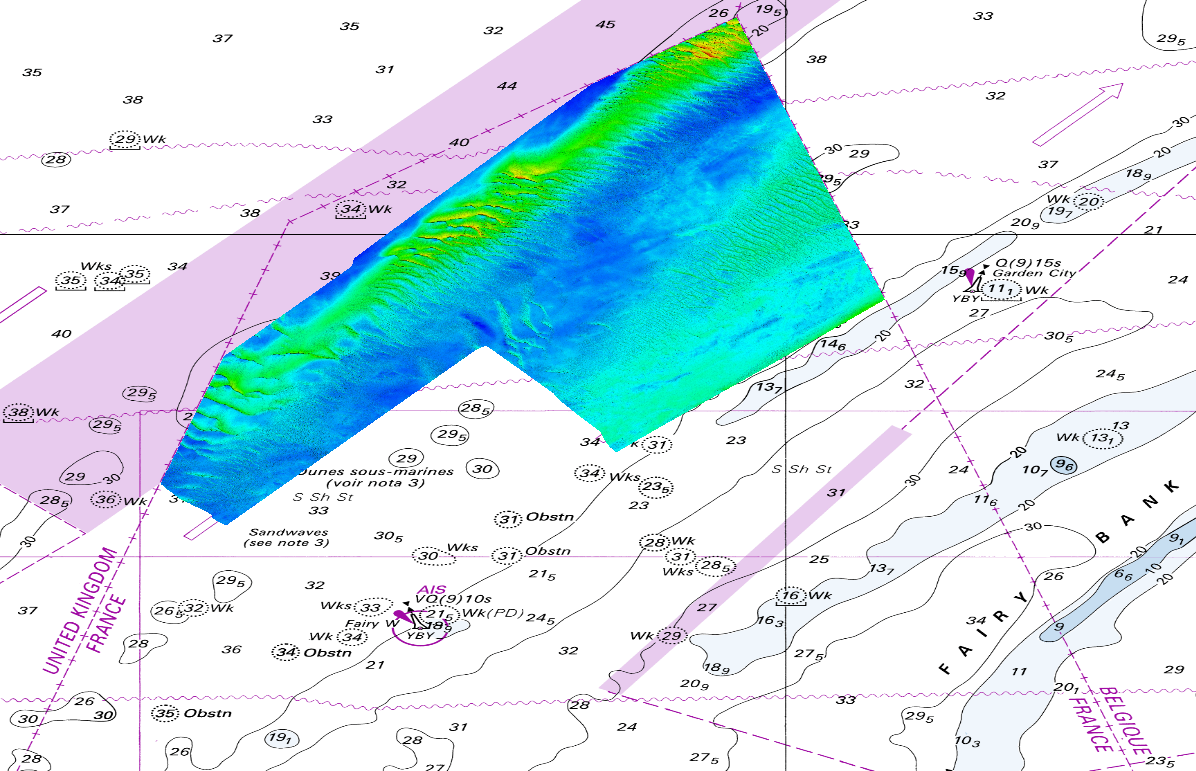
540_DTM_1-1024_S201502800-1
The DTM is produced from the S201502800-1 multibeam echosounder survey, acquired in 2015. The resolution is 1/1024 arc-minutes (~4m). It is located in front of Dunkirk (France) with depths from -16.4m to -43.3m. Depths are referenced to the Lowest Astronomical Tide and the coordinates are expressed into the WGS84 reference frame. Data and metadata associated to the survey are available on the website http://diffusion.shom.fr/pro/lots-bathy.html. The DTM is not to be used for navigation.
Simple
- Date (Creation)
- 2018-10-17T00:00:00
- Date (Revision)
- 2018-10-17T00:00:00
- Citation identifier
- DTM_1-1024_S201502800-1
- Point of contact
-
Organisation name Individual name Electronic mail address Role Shom
Originator Shom
Custodian
-
Parameter Discovery Vocabulary (P02)
-
-
Bathymetry and Elevation
-
-
SeaDataNet device categories
-
-
multi-beam echosounders
-
-
Vertical Datum
-
-
Lowest Astronomical Tide
-
-
Project name
-
-
EMODnet HRSM
-
-
Thèmes Sextant
-
-
/Physical Environment/Bathymetry/Digital Terrain Model
-
- Access constraints
- Creative Commons Attribution 4.0 International
- Use constraints
- Other restrictions
- Other constraints
-
DO NOT USE FOR NAVIGATION
- Spatial representation type
- Grid
- Denominator
- 1000
- Distance
- 0.000976563 Arc minute
- Language
- English
- Character set
- UTF8
- Topic category
-
- Oceans
- Begin date
- 2015-06-17T00:00:00
- End date
- 2015-07-07T00:00:00
Vertical extent
- Minimum value
- 16
- Maximum value
- 44
- Description
-
Europe
))
- Reference system identifier
- EPSG / WGS 84 (EPSG:4326) / 7.4
- Number of dimensions
- 3
- Dimension name
- Column
- Dimension size
- 12288
- Dimension name
- Row
- Dimension size
- 9217
- Dimension name
- Time
- Dimension size
- 1
- Cell geometry
- Point
- Transformation parameter availability
- No
- Checkpoint Availability
- No
- Point in Pixel
-
- Center
- Distribution format
-
Name Version NetCDF
- Distributor contact
-
Organisation name Individual name Electronic mail address Role Shom
Distributor
- Transfer size
- 1663
- OnLine resource
-
Protocol Linkage Name WWW:DOWNLOAD
https://downloads.emodnet-bathymetry.eu/high_resolution/540_DTM_1-1024_S201502800-1.emo.zip WWW:LINK
https://tiles.emodnet-bathymetry.eu/ EMODnet Bathymetry WMTS service
WWW:LINK
https://emodnet.ec.europa.eu/geoviewer EMODnet viewer
- Hierarchy level
- Dataset
Conformance result
- Title
-
Shoal bias
- Date
- Explanation
-
No
- Pass
- Yes
Quantitative attribute accuracy
- Name of measure
-
depth
- Measure identification
- depth accuracy
Quantitative result
- Value
- not defined
Gridded data positional accuracy
- Name of measure
-
horizontal accuracy
- Measure identification
- horizontal accuracy of coordinate
Quantitative result
- Value type
- horizontal accuracy
Absolute external positional accuracy
- Name of measure
-
emodnet-bathymetry.QI.Horizontal
- Value
- 3 - < 20 m
Absolute external positional accuracy
- Name of measure
-
emodnet-bathymetry.QI.Vertical
- Value
- 4 - MBES High frequency (higher that 100kHz) (1+0.5%d)
Domain consistency
- Name of measure
-
emodnet-bathymetry.QI.Purpose
- Value
- 3 - Hydrographic survey or compatible with hydrographic standards
- Hierarchy level
- Software
- Other
-
software
- Hierarchy level
- Property type
- Description
-
parameters of data processing
- Description
-
S201502800-1
Metadata
- File identifier
- SDN_CPRD_540_DTM_1-1024_S201502800-1 XML
- Metadata language
- English
- Character set
- UTF8
- Hierarchy level name
-
Composite Product Record
- Date stamp
- 2022-09-21T06:57:49.518Z
- Metadata standard name
-
ISO 19115:2003/19139 - EMODNET - BATHYMETRY
- Metadata standard version
-
1.0
- Metadata author
-
Organisation name Individual name Electronic mail address Role Shom
Author
)))
