 EMODnet product catalogue
A broad-scale long-term dataset of Sabellaria alveolata distribution and abundance curated through the REEHAB (REEf HABitat) Project
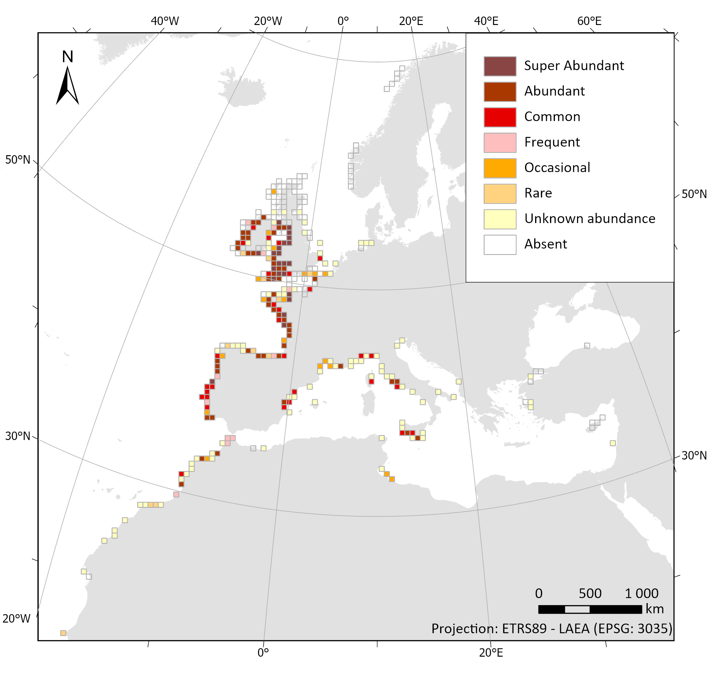
Numerous reef-forming species have declined dramatically in the last century, many of which have been insufficiently documented due to anecdotal or hard-to-access information. One of them, the honeycomb worm Sabellaria alveolata (L.) is a tube-building polychaete that can form large reefs, providing important ecosystem services such as coastal protection and habitat provision. It ranges from Scotland to Morocco, yet little is known about its distribution outside of the United Kingdom, where it is protected and where there is a strong heritage of natural history and sustained observations. As a result, online marine biodiversity information systems currently contain haphazardly distributed records of S. alveolata. One of the objectives of the REEHAB project ( https://www.inaturalist.org/). 80% of these records were not previously referenced in any online information system. Additionally, historic field notebooks from Edouard Fischer-Piette and Gustave Gilson were scanned for S. alveolata information and manually entered. Each of the 21512 S. alveolata records were checked for spatial and taxonomic accuracy, particularly in the English Channel and the North Sea where incorrectly identified observations of intertidal Sabellaria spinulosa were recorded. A further 54 observations are recorded as ‘Sabellaria spp.’ as the available information did not allow for an identification to species level. Many sources reported abundances based on the semi-quantitative SACFOR scale whilst others simply noted its presence, and others still verified both its absence and presence. The result is a curated and comprehensive dataset spanning over two centuries on the past and present global distribution and abundance of S. alveolata. Sabellaria alveolata records projected onto a 50km grid. When SACFOR scale abundance scores were given to occurrence records, the highest abundance value per grid cell was retained. Image Reference: https://www.seanoe.org/data/00610/72164/illustrations/illustration-79.gif.
Important Note: This submission has been initially submitted to SEA
scieNtific Open data Edition (SEANOE) publication service and received the recorded DOI.
The metadata elements have been further processed (refined) in EMODnet
Ingestion Service in order to conform with the Data Submission Service
specifications.
Simple
- Date (Creation)
- 2020-02-01
- Date (Revision)
- 2022-02-21
- Date (Publication)
- 2022-06-02
- Date (Publication)
- Citation identifier
- a53ad03f-3732-7323-3231-000000072164
- Code
- DOI:10.17882/72164
- Other citation details
-
Curd Amelia, Cordier Celine, Firth Louise B., Bush Laura, Gruet Yves, Le Mao Patrick, Blaze Julie A., Board Callum, Bordeyne François, Burrows Michael T., Cunningham Paul N., Davies Andrew J., Desroy Nicolas, Edwards Hugh, Harris Daniel R., Hawkins Stephen J., Kerckhof Francis, Lima Fernando P., McGrath David, Meneghesso Claudia, Mieszkowska Nova, Nunn Julia D., Nunes Flavia, O’ Connor Nessa E., O’ Riordan Ruth M., Power Anne Marie, Seabra Rui, Simkanin Christina, Dubois Stanislas (2020). A broad-scale long-term dataset of Sabellaria alveolata distribution and abundance curated through the REEHAB (REEf HABitat) Project. SEANOE. https://doi.org/10.17882/72164
- Point of contact
-
Organisation name Individual name Electronic mail address Role SEA scieNtific Open data Edition Publisher Ifremer, Scientific Information Systems for the sea Dataset Holding Organisation Ifremer, Scientific Information Systems for the sea Author
- Keywords
-
- Access constraints
- Other restrictions
- Other constraints
- no limitations to public access
- Use limitation
-
Conditions for access and use apply
- Use constraints
- Other restrictions
- Other constraints
-
CC-BY 4.0
- Character set
- UTF8
- Topic category
-
- Oceans
- Begin date
- 1821-01-01
- End date
- 2019-01-01
))
- Unique resource identifier
- WGS 1984
Spatial representation info
- Distribution format
-
Name Version Delimited 1
- OnLine resource
-
Protocol Linkage Name WWW:DOWNLOAD-1.0-http--download
https://cloud.emodnet-ingestion.eu/index.php/s/i928VftiljiB9Ii WWW:LINK-1.0-http--link
- Hierarchy level
- Dataset
Conformance result
- Title
-
COMMISSION REGULATION (EC) No 1205/2008 of 3 December 2008 implementing Directive 2007/2/EC of the European Parliament and of the Council as regards metadata
- Date (Publication)
- 2010-12-08
- Explanation
-
See the referenced specification
- Pass
- No
Conformance result
- Title
-
Corrigendum to INSPIRE Metadata Regulation published in the Official Journal of the European Union, L 328, page 83
- Date (Publication)
- 2010-12-08
- Explanation
-
See the referenced specification
- Pass
- No
Conformance result
- Title
-
Commission Regulation (EU) No 1089/2010 of 23 November 2010 implementing Directive 2007/2/EC of the European Parliament and of the Council as regards interoperability of spatial data sets and services
- Date (Publication)
- 2010-12-08
- Explanation
-
See the referenced specification
- Pass
- No
- Statement
-
Quality controlled data
Metadata
- File identifier
- a53ad03f-3732-7323-3231-000000072164 XML
- Metadata language
- English
- Character set
- UTF8
- Hierarchy level
- Dataset
- Date stamp
- 2025-05-09T00:00:00
- Metadata standard name
-
ISO 19115:2003/19139
- Metadata standard version
-
1.0
- Metadata author
-
Organisation name Individual name Electronic mail address Role Ifremer, Centre de Bretagne Point of contact
)))
