 EMODnet product catalogue
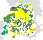
Cartographie des peuplements benthiques de l'Ile d'Er (Source Retière C., Hamon D., Jouan G., 1974) - Echelle 1/6000
Cette cartographie des peuplements benthiques de l'├«le d'Er constitue la synth├¿se de l'├®tude men├®e par C. Reti├¿re, D. Hamon et G. Jouan du Mus├®um National d'Histoire Naturelle, Laboratoire maritime de Dinard et publi├®es sous forme papier en 1974.
Pour cette ├®tude, des prospections terrain ont ├®t├® r├®alis├®es au cours de l'├®t├® 1974.
Simple
- Alternate title
-
FR000052
- Date (Publication)
- 2010-05-17T14:23:00
- Citation identifier
- FRE-330-715-368-00032-IFR_RBT_PEUPL_ILE_ER_P
- Presentation form
- Digital map
- Credit
-
Rebent
- Status
- Completed
- Point of contact
-
Organisation name Individual name Electronic mail address Role Ifremer
Responsable Rebent Bretagne
Point of contact Mus├®um National d'Histoire Naturelle
Christian Retière
Point of contact Ifremer
Dominique Hamon
Point of contact
- Maintenance and update frequency
- As needed
-
external.theme.inspire-theme
-
-
Habitats et biotopes
-
-
external.theme.gemet
-
-
habitat
-
peuplement (biologique)
-
benthos
-
zone intertidale
-
- Theme
-
-
substrat
-
Rebent
-
- Discipline
-
-
Recherche
-
- Place
-
-
Manche
-
Bretagne
-
Embouchure du Jaudy
-
Plougrescant
-
Ile d'Er
-
-
Region
-
-
France
-
- Use limitation
-
Ce produit num├®rique a ├®t├® ├®labor├® dans le cadre du Syst├¿me d'Information sur la Nature et les Paysages volet Mer, SINP Mer et le REseau de surveillance de la flore et de la faune BENthiques marines REBENT, r├®seau qui associe des partenaires appartenant ├á divers organismes. La coordination du REBENT est assur├®e par l'Ifremer qui assure ├®galement l'administration des produits. Ce produit REBENT a ├®t├® r├®alis├® en partenariat entre l'Ifremer et le Mus├®um National d'Histoire Naturelle de Dinard ├á l'origine de la donn├®e source. Avant toute utilisation lire la charte r├®gissant les droits d'usage ( http://www.rebent.org/fr/documentation/conditions-d-utilisation-des-documents.php). Ces fichiers sont destin├®s ├á un usage personnel. Toute utilisation commerciale de ces donn├®es est strictement interdite. Pour tout usage autre que personnel, veuillez prendre contact avec l'Administrateur du serveur Sextant ( sextant@ifremer.fr). Toute modification de ces donn├®es est soumise ├á une autorisation pr├®alable. Pour cela veuillez prendre contact avec la Responsable de la valorisation des produits cartographiques du REBENT ( contact@rebent.org).
- Access constraints
- Copyright
- Use constraints
- Other restrictions
- Other constraints
-
Obligation de citation sur la carte : "Source Reti├¿re C., Hamon D., Jouan G., 1974 ; Produit num├®rique REBENT-SINP Ifremer-MNHN, 2010"
- Other constraints
-
Obligation de citation dans la bibliographie : "Cartographie des peuplements benthiques de l'├«le d'Er (Source Reti├¿re C., Hamon D., Jouan G., 1974) - Echelle 1/6000, Produit num├®rique REBENT-SINP Ifremer-MNHN ; Source : - Reti├¿re C., Hamon D., Jouan G., 1974, Etude ├®cologique de l'├«le d'Er, Mus├®um National d'Histoire Naturelle, Dinard. 26 p., 7 annexes cartographiques"
- Spatial representation type
- Vector
- Denominator
- 6000
- Language
-
fre
- Character set
- UTF8
- Topic category
-
- Biota
))
- Begin date
- 1974-05-01T00:00:00
- End date
- 1974-09-30T14:35:00
- Supplemental Information
-
Les cartes de peuplements issues de ce travail ont fait l'objet en 2010 d'une num├®risation dans le cadre du SINP Mer (Syst├¿me d'Information sur la Nature et les Paysages, volet Mer), avec le soutien du REBENT (REseau de surveillance de la flore et de la faune BENThique marine).
La carte et ses m├®tadonn├®es sont publi├®es sur le site Web du REBENT, http://www.rebent.org, et les donn├®es sont bancaris├®es dans le serveur SEXTANT, serveur de donn├®es g├®or├®f├®renc├®es marines, http://www.ifremer.fr/sextant .
- Reference system identifier
- EPSG / WGS 84 (EPSG:4326) / 7.4
- Topology level
- Geometry only
- Geometric object type
- Complex
- Geometric object count
- 31
Distributor
- Distributor contact
-
Organisation name Individual name Electronic mail address Role Ifremer - Centre de Brest
Administrateur du serveur Sextant
Distributor
- Distributor format
-
Name Version Fichier de formes
ESRI ArcGIS 9.3
- OnLine resource
-
Protocol Linkage Name WWW:LINK-1.0-http--link
http://www.rebent.org/cartographie/ WWW:LINK-1.0-http--link
http://www.rebent.org/fr/documentation/conditions-d-utilisation-des-documents.php WWW:LINK-1.0-http--link
http://www.rebent.org/docs/metadata/05_HabitatsHistoriques/02_HabitatsLegendeAuteurs/10A_IleDEr/ifr_peuplement_Hamon_IleDEr_l2_p_StructureDetailleeTableAttributaire.pdf WWW:LINK-1.0-http--link
https://www.emodnet-seabedhabitats.eu/resources/mesh-archive/ WWW:LINK-1.0-http--link
http://www.rebent.org/fr/le-rebent/projet-europeen-mesh/guide-mesh.php WWW:LINK-1.0-http--link
http://www.rebent.org/docs/metadata/05_HabitatsHistoriques/02_HabitatsLegendeAuteurs/10A_IleDEr/ifr_peuplement_Hamon_IleDEr_l2_p_QualiteCarto.pdf WWW:LINK-1.0-http--link
http://www.ifremer.fr/sextant/fr/web/guest/geoviewer?url=http://www.rebent.org/docs/data/Rebent_carto/IledEr1974_context.xml
- Hierarchy level
- Dataset
Conformance result
- Title
-
INSPIRE
- Date (Publication)
- 2007-03-14
- Explanation
-
Non ├®valu├®
- Pass
- No
- Statement
-
SOURCES :
- Reti├¿re C., Hamon D., Jouan G., 1974, Etude ├®cologique de l'├«le d'Er, Mus├®um National d'Histoire Naturelle, Laboratoire Maritime, Dinard. 26 p., 7 annexes cartographiques.
- Description
-
OBJECTIF DE L'ETUDE :
Les auteurs se sont fix├®s comme objectif de cartographier et de caract├®riser les communaut├®s benthiques de l'espace intertidal d├®limit├® par la grande et la petite Ile d'Er. Les 7 cartes annexes dont est issue la " Carte de la r├®partition des habitats benthiques de l'├«le d'Er ", sont le r├®sultat du traitement, de l'agr├®gation et de l'analyse des pr├®l├¿vements et observations effectu├®s sur les substrats meubles (majoritaires) et durs du secteur.
- Description
-
METHODOLOGIE DE TRAITEMENT DE DONNEES :
Les prospections terrain ont eu lieu lors des grandes mar├®es au cours de l'├®t├® 1974 avec vingt-trois transects r├®partis en fonction de la superficie et de la diversit├® morphologique des zones exondables. Sur chacun d'eux 3 types de pr├®l├¿vements ont ├®t├® effectu├®s :
- Des pr├®l├¿vements " ├á vue " au niveau des lev├®es de galets, des champs de blocs et des substrats durs.
- Des pr├®l├¿vements qualitatifs, tamis├®s sur toile m├®tallique de maille carr├®e de 2 mm sur substrats meubles.
- Des pr├®l├¿vements quantitatifs, dont le volume est estim├® ├á l'aide d'une cuvette jaug├®e.
En fonction des premiers r├®sultats, une s├®rie de 11 stations a ├®t├® retenue ult├®rieurement au niveau des principaux faci├¿s de substrat meubles. A chaque station, 5 pr├®l├¿vements sont r├®alis├®s ├á l'aide d'un parall├®l├®pip├¿de de 10 cm sur 30 cm de hauteur et tamis├®s sur toile m├®tallique de maille carr├®e de 1 mm.
Ces pr├®l├¿vements permettent de d├®finir la densit├® de population des esp├¿ces, la dominance des groupes zoologiques ainsi que leur biomasse.
Les param├¿tres ├®daphiques ├®tudi├®s, afin d'affiner les caract├®ristiques sp├®cifiques aux diff├®rents biotopes, sont la granulom├®trie, le taux de carbonate et le taux de mati├¿re organique.
- Description
-
PREMIERS ELEMENTS DE CONCLUSION :
De cette ├®tude bionomique ressortent les points suivants :
- les unit├®s c├®notiques de substrats meubles sont tr├¿s largement dominantes.
- l'originalit├® ├®cologique de l'estran est d├╗e ├á l'existence de successions de lev├®es de galets et ├á la pr├®sence de petites plages de sables alv├®olaires ainsi qu'├á l'interp├®n├®tration des faunes terrestres et marines.
- l'analyse qualitative num├®rique des peuplements montre l'importance des ann├®lides polych├¿tes.
- les biomasses ├®lev├®es permettent de consid├®rer cet estran comme une r├®serve de mati├¿re vivante pour l'avifaune.
- Description
-
CONTEXTE DE LA NUMERISATION :
Un inventaire et une valorisation des cartographies historiques autour de la Bretagne a ├®t├® entreprise depuis 2008 dans le cadre du SINP Mer (Syst├¿me d'Information sur la Nature et les Paysages, volet Mer) avec le soutien du REBENT (REseau de surveillance de la flore et de la faune BENThique marine) :
- num├®risation et mise en forme des cartes ;
- mise en ligne des cartes et des m├®tadonn├®es associ├®es sur le site Web du REBENT, http://www.rebent.org ;
- bancarisation dans le serveur SEXTANT, http://www.ifremer.fr/sextant.
- Description
-
METHODOLOGIE DE LA NUMERISATION :
Coordination IFREMER DYNECO/AG Chantal Croguennec et Etienne Laffay, dans le cadre du Système d'Information sur la Nature et les Paysages volet Mer (SINP Mer), sous-traitance B.E.T.I.
Plusieurs op├®rations ont ├®t├® n├®cessaires ├á l'obtention d'un support num├®rique de l'information contenue dans des documents papier :
- Les cartes papier ont ├®t├® scann├®es au trait avec une d├®finition de 400 dpi.
- Les fichiers scann├®s ont ├®t├® g├®or├®f├®renc├®s puis num├®ris├®s.
- Le r├®sultat de la num├®risation a ├®t├® enregistr├® sous ArcView 9 au format shape.
- Pour chaque polygone a ├®t├® indiqu├®e, dans un champ de la table attributaire, la valeur correspondante de la l├®gende de la carte.
Le r├®f├®rentiel utilis├® comme trait de c├┤te est celui de Ifremer-Shom au 1/25000 (date de r├®vision 1995).
- Description
-
QUALITE DE LA CARTOGRAPHIE :
Qualit├® de l'imagerie : sans objet
Qualit├® de la v├®rit├® terrain : 70 %
Qualit├® de l'interpr├®tation : 67 %
-> Score final : 46 % (fiabilit├® moyenne, comprise entre 35 et 54 %)
Metadata
- File identifier
- b5a501b1-4a51-4c7f-a351-ea7bcd1cce8c XML
- Metadata language
-
fre
- Character set
- UTF8
- Date stamp
- 2022-02-17T15:31:56
- Metadata standard name
-
ISO 19115:2003/19139
- Metadata standard version
-
1.0
- Metadata author
-
Organisation name Individual name Electronic mail address Role Ifremer
Marie-Odile Lamirault-Gall
Point of contact
Overviews

Spatial extent
)))
Provided by
