• EMODnet Product Catalogue
  •  
  •  
  •  

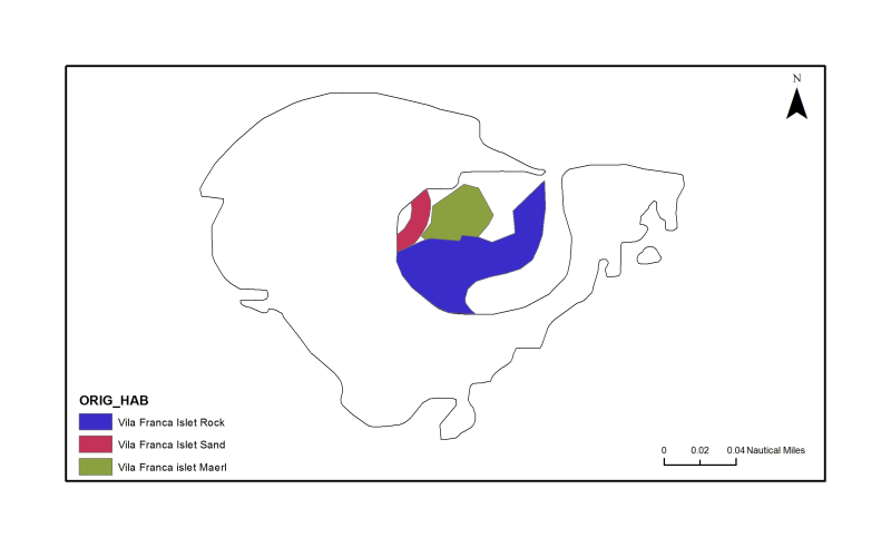
Azores: Vila Franca Islet

Vila Franca do Campo Islet Marine Reserve. The western side of the lagoon possesses a crescentic sand bank as a result of interacting wave inputs. The southern half of the lagoon comprises a rocky shelf. Offshore, the lagoon floor is dotted with “maerl” (Morton, 1990).

Identificatie

Alternatieve titel PT100003
Versiedatum 2012-10-17T15:45:00
Type versiedatum Publicatie: Uitgavedatum van de dataset.
Versie dataset(serie) Version 1

Inhoud

Doel van vervaardiging Research supported by MeshAtlantic project
Status historisch archief: De data is opgeslagen in een offline opslagmedium.

Contactgegevens dataset(serie)

Naam Contactpersoon Patricia Amorim & Fernando Tempera
Organisatie DOP/IMAR University of the Azores
Adres Rua Prof. Dr. Frederico Machado, 4
Plaats HORTA
Postcode 9900-361
Land Portugal
E-mail pamorim@uac.pt; tempera@uac.pt
Rol Contactpunt: Partij waarmee contact kan worden opgenomen voor het vergaren van kennis of verstrekking van de data.
Frequentie Niet gepland: Er zijn geen plannen om de data te actualiseren.
Voorbeeldweergave dataset(serie) https://gis.ices.dk/geonetwork/srv/api/records/bd425427-be81-4121-bc33-b25de9db7cca/attachments/IVFC_s.png
Voorbeeldweergave dataset(serie) https://gis.ices.dk/geonetwork/srv/api/records/bd425427-be81-4121-bc33-b25de9db7cca/attachments/IVFC.png

Trefwoorden

GEMET - INSPIRE themes, version 1.0 Habitats and biotopes
GDI-Vlaanderen Trefwoorden Metadata GDI-Vl-conform
Overige trefwoorden Azores
Overige trefwoorden Marine habitat mapping
Ruimtelijk schema dataset(serie) vector: Vector data wordt gebruikt om geografische data te representeren.

Ruimtelijke resolutie dataset(serie)

Noemer 5000
Karakterset UTF-8: 8-bit variabele grootte universele karakterset, gebaseerd op ISO/IEC 10646
Categorie(ën) Milieu

Begrenzing

Omschrijving geografische begrenzing
Identificator geografische begrenzing

Begrenzing

Omschrijving geografische begrenzing

Omschrijvende rechthoek

Minimum x-coordinaat -26.035336858803
Maximum x-coordinaat -25.024594671303
Minimum y-coordinaat 37.376028906622004
Maximum y-coordinaat 38.167044531622
Identificator geografische begrenzing

Begrenzing

Omschrijving geografische begrenzing
Identificator geografische begrenzing

Referentiesysteem

Horizontaal en/of verticaal referentiesysteem

Unieke code WGS 1984

Kwaliteit

Niveau kwaliteitsinformatie Dataset: Informatie heeft betrekking op de dataset.

Toegangs- en gebruiksbeperkingen

Legale en veiligheidsbeperkingen

Beperkingen van de dataset(serie)

Legale beperkingen

(Juridische) toegangsbeperking copyright: Exclusief recht voor publicatie, productie, of verkoop van rechten op een literair, theater, muzikaal of artistiek werk, of op het gebruik van een commerciële druk of label, toegekend bij wet voor een specifieke periode of tijd aan een auteur, componist, artiest of distributeur.

Distributie

Distributieformaat Shapefile (Version: ArcGIS 10)

Overdracht

OnLine bronnen

Protocol WWW:LINK-1.0-http--link

OnLine bronnen

Connectiepunt URL https://www.emodnet-seabedhabitats.eu/access-data/launch-map-viewer/?zoom=18&center=-25.44304,37.70570&layerIds=502&baseLayerId=1&activeFilters=NobwRANghgngpgJwJIBMwC4CsAGATAGjADMBLCAF0VQwBYAOQ0ixAGQHs2BrAVwAdUAzhmABdRmUoIAKnAAe5DGAAKUgIzYN2AMxgAviKA
Protocol WWW:LINK-1.0-http--link
Naam EMODnet Seabed Habitats Map Viewer
Beschrijving View map "PT100003" on the EMODnet Seabed Habitats Map Viewer

OnLine bronnen

Connectiepunt URL https://www.emodnet-seabedhabitats.eu/access-data/download-data/?gui=PT100003
Protocol WWW:LINK-1.0-http--link
Naam EMODnet Seabed Habitats Download Page
Beschrijving Visit the EMODnet Seabed Habitats download page with map "PT100003" preselected for download

OnLine bronnen

Connectiepunt URL https://ows.emodnet-seabedhabitats.eu/emodnet_view_maplibrary/wms?
Protocol OGC:WMS
Naam pt100003
Beschrijving View map "PT100003" through the EMODnet Seabed Habitats "Map Library" Web Map Service

OnLine bronnen

Connectiepunt URL https://ows.emodnet-seabedhabitats.eu/emodnet_open_maplibrary/wfs?
Protocol OGC:WFS
Naam pt100003
Beschrijving Access data from map "PT100003" through the EMODnet Seabed Habitats "Map Library" Web Feature Service

Meta-metadata

Metadata identificator (fileIdentifier) bd425427-be81-4121-bc33-b25de9db7cca
Karakterset metadatarecord UTF-8: 8-bit variabele grootte universele karakterset, gebaseerd op ISO/IEC 10646
Metadata wijzigingsdatum 2020-01-22T11:23:55
Naam metadatastandaard ISO 19115:2003/19139
Versie metadatastandaard 1.0

Metadata-auteur

Naam Contactpersoon Patricia Amorim and Fernando Tempera
Organisatie DOP/IMAR University of the Azores
Plaats HORTA
Postcode 9900-361
Land Portugal
E-mail pamorim@uac.pt; tempera@uac.pt
Rol Contactpunt: Partij waarmee contact kan worden opgenomen voor het vergaren van kennis of verstrekking van de data.

Overviews

thumbnail
large_thumbnail