 EMODnet product catalogue
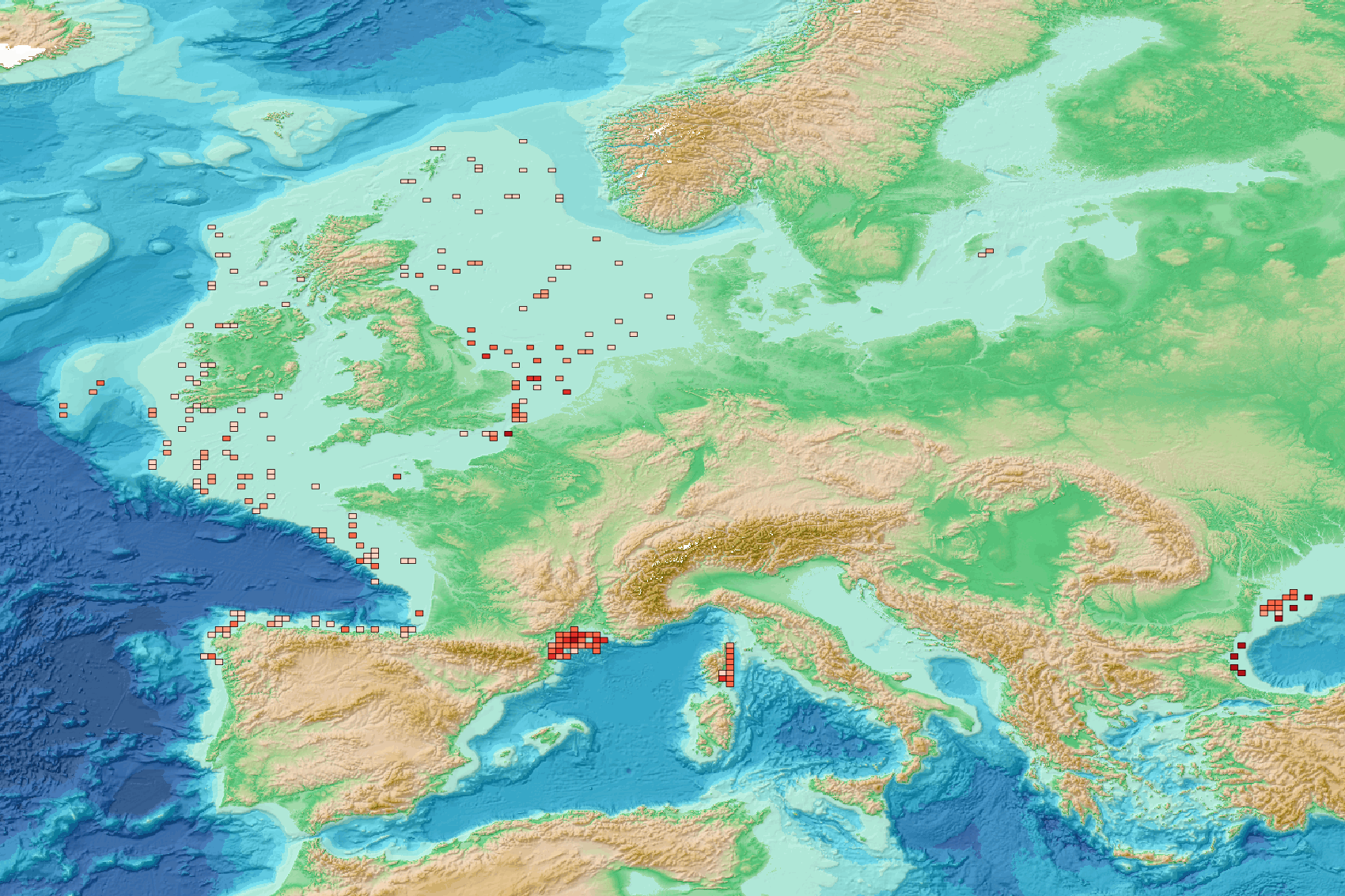
Seafloor litter - Spatial distribution of plastic bags density normalized per km² 2011/2022 v2023
This visualization product displays the spatial distribution of plastic bags density per trawl.
EMODnet Chemistry included the collection of marine litter in its 3rd phase. Since the beginning of 2018, data of seafloor litter collected by international fish-trawl surveys have been gathered and processed in the EMODnet Chemistry Marine Litter Database (MLDB).
The harmonization of all the data has been the most challenging task considering the heterogeneity of the data sources, sampling protocols (OSPAR and MEDITS protocols) and reference lists used on a European scale. Moreover, within the same protocol, different gear types are deployed during fishing bottom trawl surveys.
In cases where the wingspread and/or number of items were unknown, data could not be used because these fields are needed to calculate the density. Data collected before 2011 are affected by this filter.
When the distance reported in the data was null, it was calculated from:
- the ground speed and the haul duration using this formula: Distance (km) = Haul duration (h) * Ground speed (km/h);
- the trawl coordinates if the ground speed and the haul duration were not filled in.
The swept area is calculated from the wingspread (which depends on the fishing gear type) and the distance trawled:
Swept area (km²) = Distance (km) * Wingspread (km)
Densities have been calculated on each trawl and year using the following computation:
Density of plastic bags (number of items per km²) = ∑Number of plastic bags related items / Swept area (km²)
Then a grid with 30km x 30km cells is used to calculate the weighted mean of densities in each cell from the formula :
Weighted mean (number of items per km²) = ∑ (Distance (km) * Density (number of items per km²)) / ∑ Distance (km)
Percentiles 50, 75, 95 & 99 have been calculated taking into account data for all years.
More information on data processing and calculation are detailed in the document attached.
Warning: the absence of data on the map doesn't necessarily mean that they don't exist, but that no information has been entered in the Marine Litter Database for this area.
This work is based on the work presented in the following scientific article:
O. Gerigny, M. Brun, M.C. Fabri, C. Tomasino, M. Le Moigne, A. Jadaud, F. Galgani, Seafloor litter from the continental shelf and canyons in French Mediterranean Water: Distribution, typologies and trends, Marine Pollution Bulletin, Volume 146, 2019, Pages 653-666, ISSN 0025-326X, https://doi.org/10.1016/j.marpolbul.2019.07.030.
Simple
- Alternate title
-
sl_spatialdistribution_plasticbagabundance_30km
- Date (Creation)
- 2023-07-25
- Edition
-
1.0
- Citation identifier
- DOI:10.13120/df09d7cc-fda3-4e23-8e0d-aea6add88805
- Credit
-
EMODnet Chemistry
Point of contact
-
Thèmes Sextant
-
-
/Human Activities/Pollution
-
- Theme
-
-
EMODnet Chemistry
-
-
Mission Atlantic - Resources
-
-
Data
-
-
Mission Atlantic - Case Studies
-
-
Celtic Seas
-
-
Mission Atlantic - Work Package
-
-
WP4 Benthic Mapping
-
-
Mission Atlantic - BODC Parameters
-
-
/Environment/Pollution
-
-
Mission Atlantic - Data type (DMP)
-
-
Spatial data products
-
-
Ocean Hackathon - City and challenge
-
-
/Boulogne-sur-Mer/BOL02
-
/Boulogne-sur-Mer/BOL04
-
/Bournemouth/BOR01
-
/Kuala Lumpur/KUL08
-
/Boulogne-sur-Mer/BOL06
-
/Concepción/CON06
-
/La Rochelle/LAR01
-
/Peniche/PEN01
-
/Boulogne-sur-Mer
-
/Bournemouth
-
/Brest
-
/Cherbourg
-
/La Rochelle
-
/Plymouth
-
/Toulon
-
- Use limitation
-
CC BY 4.0: https://creativecommons.org/licenses/by/4.0/
- Access constraints
- Other restrictions
- Use constraints
- Creative Commons Attribution 4.0 International
- Other constraints
-
Usage is subject to mandatory citation: "This resource was generated in the framework of EMODnet Chemistry, under the support of DG MARE Call for Tender EASME/EMFF/2018/1.3.1.8 - lot4."
- Spatial representation type
- Vector
- Language
-
eng
- Topic category
-
- Oceans
- Description
-
bounding box
))
- Begin date
- 2011-05-03
- End date
- 2022-11-27
Vertical extent
- Minimum value
- -5500.0
- Maximum value
- 0.0
- Reference system identifier
- EPSG / WGS 84 (EPSG:4326)
- Geometric object type
- Point
- Distribution format
-
Name Version
- OnLine resource
- Hierarchy level
- Series
Conformance result
- Title
-
COMMISSION REGULATION (EU) No 1089/2010 of 23 November 2010 implementing Directive 2007/2/EC of the European Parliament and of the Council as regards interoperability of spatial data sets and services
- Date (Publication)
- 2010-12-08
- Explanation
-
See the referenced specification
- Statement
-
The data used as input for this product have been extracted from the EMODnet Chemistry Download Service: https://emodnet-chemistry.maris.nl/search
Metadata
- File identifier
- df09d7cc-fda3-4e23-8e0d-aea6add88805 XML
- Metadata language
- English
- Character set
- UTF8
- Hierarchy level
- Series
- Hierarchy level name
-
Product record
- Date stamp
- 2025-02-21T09:18:25.543011Z
- Metadata standard name
-
ISO 19115:2003/19139 - EMODNET - SDN
- Metadata standard version
-
1.0
- Metadata author
-
Organisation name Individual name Electronic mail address Role EMODnet Chemistry
Point of contact
)))
