• EMODnet Product Catalogue
  •  
  •  
  •  

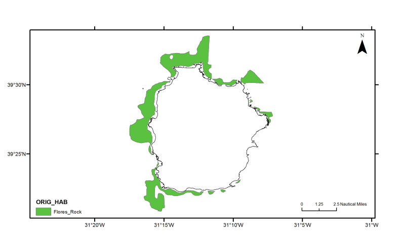
Azores: Flores rock substrate

Flores rock substrate from seismic subbottom profiles interpretation. (Bates, C.R., 2005. Sub-Bottom Profiling for Sand Resource Assessment, Flores Island, Azores. Team Internal Report 05-04)

Identificatie

Alternatieve titel PT100004
Versiedatum 2012-10-17T16:25:00
Type versiedatum Publicatie: Uitgavedatum van de dataset.
Versie dataset(serie) Version 1.0

Inhoud

Doel van vervaardiging Research supported by MeshAtlantic project
Status historisch archief: De data is opgeslagen in een offline opslagmedium.

Contactgegevens dataset(serie)

Naam Contactpersoon Patricia Amorim & Fernando Tempera
Organisatie DOP/IMAR University of the Azores
Adres Rua Prof. Dr. Frederico Machado, 4
Plaats HORTA
Postcode 9900-361
Land Portugal
E-mail pamorim@uac.pt; tempera@uac.pt
Rol Contactpunt: Partij waarmee contact kan worden opgenomen voor het vergaren van kennis of verstrekking van de data.
Frequentie Niet gepland: Er zijn geen plannen om de data te actualiseren.
Voorbeeldweergave dataset(serie) https://gis.ices.dk/geonetwork/srv/api/records/e1622d30-6b02-4e92-bed5-838bcff956c4/attachments/Flores_rock_s.png
Voorbeeldweergave dataset(serie) https://gis.ices.dk/geonetwork/srv/api/records/e1622d30-6b02-4e92-bed5-838bcff956c4/attachments/Flores_rock.png

Trefwoorden

GEMET - INSPIRE themes, version 1.0 Habitats and biotopes
GDI-Vlaanderen Trefwoorden Metadata GDI-Vl-conform
Overige trefwoorden Azores
Overige trefwoorden Marine habitat mapping
Ruimtelijk schema dataset(serie) vector: Vector data wordt gebruikt om geografische data te representeren.

Ruimtelijke resolutie dataset(serie)

Noemer 200000
Karakterset UTF-8: 8-bit variabele grootte universele karakterset, gebaseerd op ISO/IEC 10646
Categorie(ën) Milieu

Begrenzing

Omschrijving geografische begrenzing
Identificator geografische begrenzing

Begrenzing

Omschrijving geografische begrenzing

Omschrijvende rechthoek

Minimum x-coordinaat -31.291198730469
Maximum x-coordinaat -31.079711914063004
Minimum y-coordinaat 39.326153564453
Maximum y-coordinaat 39.559613037109
Identificator geografische begrenzing

Begrenzing

Omschrijving geografische begrenzing
Identificator geografische begrenzing

Referentiesysteem

Horizontaal en/of verticaal referentiesysteem

Unieke code WGS 1984

Kwaliteit

Niveau kwaliteitsinformatie Dataset: Informatie heeft betrekking op de dataset.

Toegangs- en gebruiksbeperkingen

Legale en veiligheidsbeperkingen

Beperkingen van de dataset(serie)

Legale beperkingen

(Juridische) toegangsbeperking copyright: Exclusief recht voor publicatie, productie, of verkoop van rechten op een literair, theater, muzikaal of artistiek werk, of op het gebruik van een commerciële druk of label, toegekend bij wet voor een specifieke periode of tijd aan een auteur, componist, artiest of distributeur.

Distributie

Distributieformaat Shapefile (Version: ESRI ArcGIS 10)

Overdracht

OnLine bronnen

Protocol WWW:LINK-1.0-http--link

OnLine bronnen

Connectiepunt URL https://www.emodnet-seabedhabitats.eu/access-data/launch-map-viewer/?zoom=12&center=-31.20542,39.45330&layerIds=501&baseLayerId=1&activeFilters=NobwRANghgngpgJwJIBMwC4CsAGAjAGjADMBLCAF0VQwBYB2Q0ixAGQHs2BrAVwAdUAzhmABdRmUoIAKnAAe5DGAAKU3NnXYaYAL4igA
Protocol WWW:LINK-1.0-http--link
Naam EMODnet Seabed Habitats Map Viewer
Beschrijving View map "PT100004" on the EMODnet Seabed Habitats Map Viewer

OnLine bronnen

Connectiepunt URL https://www.emodnet-seabedhabitats.eu/access-data/download-data/?gui=PT100004
Protocol WWW:LINK-1.0-http--link
Naam EMODnet Seabed Habitats Download Page
Beschrijving Visit the EMODnet Seabed Habitats download page with map "PT100004" preselected for download

OnLine bronnen

Connectiepunt URL https://ows.emodnet-seabedhabitats.eu/emodnet_view_maplibrary/wms?
Protocol OGC:WMS
Naam pt100004
Beschrijving View map "PT100004" through the EMODnet Seabed Habitats "Map Library" Web Map Service

OnLine bronnen

Connectiepunt URL https://ows.emodnet-seabedhabitats.eu/emodnet_open_maplibrary/wfs?
Protocol OGC:WFS
Naam pt100004
Beschrijving Access data from map "PT100004" through the EMODnet Seabed Habitats "Map Library" Web Feature Service

Meta-metadata

Metadata identificator (fileIdentifier) e1622d30-6b02-4e92-bed5-838bcff956c4
Karakterset metadatarecord UTF-8: 8-bit variabele grootte universele karakterset, gebaseerd op ISO/IEC 10646
Metadata wijzigingsdatum 2020-01-15T12:21:50
Naam metadatastandaard ISO 19115:2003/19139
Versie metadatastandaard 1.0

Metadata-auteur

Naam Contactpersoon Patricia Amorim and Fernando Tempera
Organisatie DOP/IMAR University of the Azores
Plaats HORTA
Postcode 9900-361
Land Portugal
E-mail pamorim@uac.pt; tempera@uac.pt
Rol Contactpunt: Partij waarmee contact kan worden opgenomen voor het vergaren van kennis of verstrekking van de data.

Overviews

thumbnail
large_thumbnail