 EMODnet product catalogue
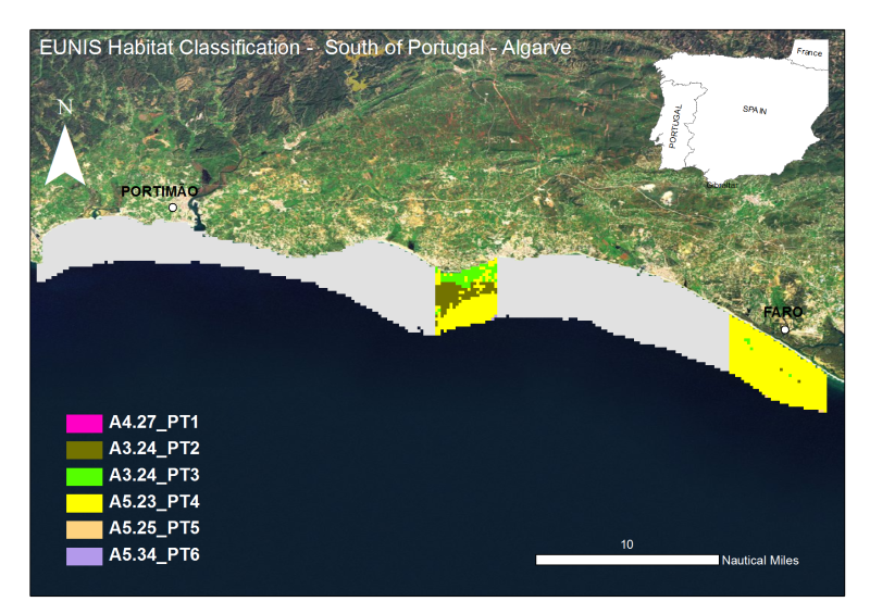
Algarve:Mapping of marine biocenoses off the National Underwater Ecological Reserve between Gal├® and Barra do Anc├úo - CCMAR-CCDRALG
The Algarve coast presents a significant portion of territory that is part of the designated National Nature Reserve, in its underwater slope (0 to 30m depth - RENSUB), especially when compared with the equivalent on land. The current digital map presents the EUNIS habitat of the central Algarve RENSUB coast. The covered area is between Gal├® and Barra do Anc├úo. The sediment classification was obtained through the interpretation of data from Side Scan Sonar (remote-sensing image), while for the habitat mapping the biological sampling was carried out with beam trawl and underwater visual census.
Simple
- Alternate title
-
PT000002
- Date (Revision)
- 2010-12-01T00:00:00
- Edition
-
2012
- Presentation form
- Digital map
- Purpose
-
Provide information on the EUNIS Habitat
- Status
- Historical archive
- Point of contact
-
Organisation name Individual name Electronic mail address Role University of Algarve (UAlg-FCT)- Centre of Marine Sciences (CCMAR)
Pedro Monteiro & Jorge Gonçalves
Author Regional Hydrological Administration of the Algarve (ARH Algarve)
Sebastião Teixeira
Point of contact
- Maintenance and update frequency
- Not planned
- Theme
-
-
Habitat, Biocenosis, Biotope, EUNIS
-
- Place
-
-
Algarve, south Portugal, Faro, Albufeira, Portimão, Lagos
-
- Discipline
-
-
Habitat Map
-
- Use limitation
-
The access and use is possible with request to the Regional Hydrological Administration of the Algarve (ARH Algarve) and Centre of Marine Sciences (CCMAR) of the University of Algarve (UAlg/FTC) and nstituto Español de Oceanografía (IEO)
- Access constraints
- License
- Use constraints
- License
- Spatial representation type
- Vector
- Denominator
- 10000
- Language
-
eng
- Character set
- UTF8
- Topic category
-
- Biota
- Begin date
- 2005-05-25T00:00:00
- End date
- 2006-09-07T00:00:00
))
Vertical extent
- Minimum value
- 0
- Maximum value
- -30
- Reference system identifier
- WGS 1984
- Distribution format
-
Name Version Shapefile
ESRI ArcGIS 9.3
- OnLine resource
-
Protocol Linkage Name WWW:LINK-1.0-http--link
http://www.rensub.com/ OGC:WMS
https://ows.emodnet-seabedhabitats.eu/geoserver/emodnet_view_maplibrary/wms? pt000002
OGC:WFS
https://ows.emodnet-seabedhabitats.eu/geoserver/emodnet_open_maplibrary/wfs? pt000002
WWW:LINK-1.0-http--link
https://files.emodnet-seabedhabitats.eu/data/EMODnetSBHsurvey_PT000002.zip EMODnet Seabed Habitats download
- Hierarchy level
- Dataset
Conformance result
- Title
-
Mapping of marine biocenoses off the National Underwater Ecological Reserve between Faro and Ponta da Piedade - CCMAR-CCDRALG
- Date (Revision)
- 2010-10-02
- Pass
- No
Metadata
- File identifier
- e6908a35-f5fa-49d3-8ca8-26affb35a7d2 XML
- Metadata language
-
eng
- Character set
- UTF8
- Date stamp
- 2020-01-23T10:19:42
- Metadata standard name
-
ISO 19115:2003/19139
- Metadata standard version
-
1.0
- Metadata author
-
Organisation name Individual name Electronic mail address Role University of Algarve (UAlg-FCT)- Centre of Marine Science (CCMAR)
Pedro Monteiro & Jorge Gonçalves
Point of contact
)))
