 EMODnet product catalogue
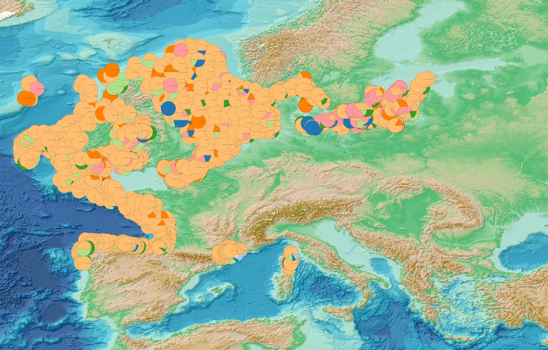
Seafloor litter - Composition of litter according to material categories in percent per trawl 2007/2021 v2021
This visualization product displays the marine litter material categories percentage per trawl.
EMODnet Chemistry included the collection of marine litter in its 3rd phase. Since the beginning of 2018, data of seafloor litter collected by international fish-trawl surveys have been gathered and processed in the EMODnet Chemistry Marine Litter Database (MLDB).
The harmonization of all the data has been the most challenging task considering the heterogeneity of the data sources, sampling protocols (OSPAR and MEDITS protocols) and reference lists used on a European scale. Moreover, within the same protocol, different gear types are deployed during fishing bottom trawl surveys.
Unlike other EMODnet seafloor litter products, all trawls surveyed since 2007 are included in this map even if the wingspread and/or the distance are unknown.
Only surveys with an unknown number of items were excluded from this product.
Harmonization of the material categories between ICES and MEDITS lists has been performed and the following calculation has been applied:
Material % = (∑Number of items of each material category*100)/(∑Number of items of all material categories)
More information on data processing and calculation are detailed in the document attached.
Warning: the absence of data on the map doesn't necessarily mean that they don't exist, but that no information has been entered in the Marine Litter Database for this area.
Simple
- Alternate title
-
sl_materialcategories
- Date (Creation)
- 2021-06-28
- Edition
-
1.0
- Citation identifier
- DOI:10.13120/e88734d3-b1a9-45a8-b5ad-29d6599000a0
- Credit
-
EMODnet Chemistry
Point of contact
-
Thèmes Sextant
-
-
/Human Activities/Pollution
-
- Theme
-
-
EMODnet Chemistry
-
-
Mission Atlantic - Resources
-
-
Data
-
-
Mission Atlantic - Case Studies
-
-
Celtic Seas
-
-
Mission Atlantic - Work Package
-
-
WP4 Benthic Mapping
-
-
Mission Atlantic - BODC Parameters
-
-
/Environment/Pollution
-
-
Mission Atlantic - Data type (DMP)
-
-
Spatial data products
-
- Use limitation
-
CC BY 4.0: https://creativecommons.org/licenses/by/4.0/
- Access constraints
- Other restrictions
- Use constraints
- Creative Commons Attribution 4.0 International
- Other constraints
-
Usage is subject to mandatory citation: "This resource was generated in the framework of EMODnet Chemistry, under the support of DG MARE Call for Tender EASME/EMFF/2018/1.3.1.8 - lot4."
- Spatial representation type
- Vector
- Language
-
eng
- Topic category
-
- Oceans
- Description
-
bounding box
))
- Begin date
- 2007-10-02
- End date
- 2021-03-16
Vertical extent
- Minimum value
- -5500.0
- Maximum value
- 0.0
- Reference system identifier
- EPSG / WGS 84 (EPSG:4326)
- Geometric object type
- Point
- Distribution format
-
Name Version
- OnLine resource
-
Protocol Linkage Name WWW:LINK
https://doi.org/10.6092/EF4901D2-642A-4881-BA81-6B2607F5485E Visualization products for Beach and Seafloor Litter data
WWW:LINK
https://dx.doi.org/10.6092/15c0d34c-a01a-4091-91ac-7c4f561ab508 Guidelines and forms for gathering marine litter data
WWW:LINK
https://sextant.ifremer.fr/documentation/emodnet_chemistry/document/Field_description/SL_field_description_materialcategories.xlsx Description of the layer's fields
DOI
https://doi.org/10.13120/e88734d3-b1a9-45a8-b5ad-29d6599000a0 Digital Object Identifier (DOI)
WWW:DOWNLOAD
https://sextant.ifremer.fr/sextant_data/EMODNET/CHEMISTRY/MARINE_LITTER/2021/sl_materialcategories.zip Direct Download
WWW:LINK
https://emodnet.ec.europa.eu/geoviewer/ EMODnet Map Viewer
- Hierarchy level
- Series
Conformance result
- Title
-
COMMISSION REGULATION (EU) No 1089/2010 of 23 November 2010 implementing Directive 2007/2/EC of the European Parliament and of the Council as regards interoperability of spatial data sets and services
- Date (Publication)
- 2010-12-08
- Explanation
-
See the referenced specification
- Statement
-
The data used as input for this product have been extracted from the EMODnet Chemistry Download Service: https://emodnet-chemistry.maris.nl/search
Metadata
- File identifier
- e88734d3-b1a9-45a8-b5ad-29d6599000a0 XML
- Metadata language
- English
- Character set
- UTF8
- Hierarchy level
- Series
- Hierarchy level name
-
Product record
- Date stamp
- 2025-02-21T09:23:10.796624Z
- Metadata standard name
-
ISO 19115:2003/19139 - EMODNET - SDN
- Metadata standard version
-
1.0
- Metadata author
-
Organisation name Individual name Electronic mail address Role EMODnet Chemistry
Point of contact
)))
