 EMODnet product catalogue
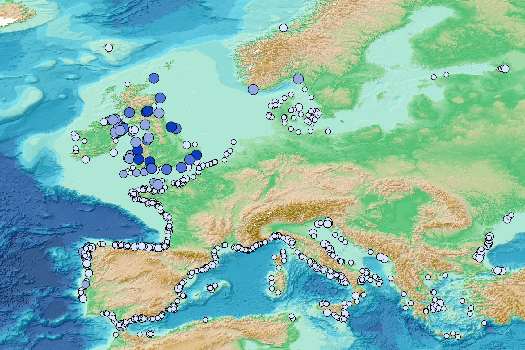
Beach litter - Number of surveys & temporal coverage per beach - Other sources 2001/2021 v2023
This visualization product displays the number of non-MSFD monitoring surveys, research & cleaning operations and the associated temporal coverage per beach.
EMODnet Chemistry included the collection of marine litter in its 3rd phase. Since the beginning of 2018, data of beach litter have been gathered and processed in the EMODnet Chemistry Marine Litter Database (MLDB).
The harmonization of all the data has been the most challenging task considering the heterogeneity of the data sources, sampling protocols and reference lists used on a European scale.
Preliminary processing were necessary to harmonize all the data:
- Exclusion of OSPAR 1000 protocol: in order to follow the approach of OSPAR that it is not including these data anymore in the monitoring;
- Selection of surveys from non-MSFD monitoring, cleaning and research operations;
- Exclusion of beaches without coordinates.
More information is available in the attached documents.
Warning: the absence of data on the map doesn't necessarily mean that they don't exist, but that no information has been entered in the Marine Litter Database for this area.
Simple
- Alternate title
-
bl_temporalcoverage_numbersurveys_other
- Date (Creation)
- 2023-06-12
- Edition
-
1.0
- Citation identifier
- DOI:10.13120/fd6acf3d-8e05-41e7-ae1a-5d2bb8fb6414
- Credit
-
EMODnet Chemistry
Point of contact
Point of contact
-
Thèmes Sextant
-
-
/Human Activities/Pollution
-
- Theme
-
-
EMODnet Chemistry
-
-
Ocean Hackathon - City and challenge
-
-
/Boulogne-sur-Mer/BOL02
-
/Boulogne-sur-Mer/BOL04
-
/Boulogne-sur-Mer/BOL06
-
/Bournemouth/BOR01
-
/Concepción/CON06
-
/Kuala Lumpur/KUL08
-
/La Rochelle/LAR01
-
/Peniche/PEN01
-
- Use limitation
-
CC BY 4.0: https://creativecommons.org/licenses/by/4.0/
- Access constraints
- Other restrictions
- Use constraints
- Creative Commons Attribution 4.0 International
- Other constraints
-
Usage is subject to mandatory citation: "This resource was generated in the framework of EMODnet Chemistry, under the support of DG MARE Call for Tender EASME/EMFF/2018/1.3.1.8 - lot4."
- Spatial representation type
- Vector
- Language
-
eng
- Topic category
-
- Oceans
- Description
-
bounding box
))
- Begin date
- 2001-01-01
- End date
- 2021-10-22
Vertical extent
- Minimum value
- 0
- Maximum value
- 0.0
- Reference system identifier
- EPSG / WGS 84 (EPSG:4326)
- Geometric object type
- Point
- Distribution format
-
Name Version
- OnLine resource
- Hierarchy level
- Series
Conformance result
- Title
-
COMMISSION REGULATION (EU) No 1089/2010 of 23 November 2010 implementing Directive 2007/2/EC of the European Parliament and of the Council as regards interoperability of spatial data sets and services
- Date (Publication)
- 2010-12-08
- Explanation
-
See the referenced specification
- Statement
-
The data used as input data for this product was extracted from the Postgis database used in the beach litter analysis for EMODnet Chemistry.
Metadata
- File identifier
- fd6acf3d-8e05-41e7-ae1a-5d2bb8fb6414 XML
- Metadata language
- English
- Character set
- UTF8
- Hierarchy level
- Series
- Hierarchy level name
-
Product record
- Date stamp
- 2025-02-21T08:54:52.405778Z
- Metadata standard name
-
ISO 19115:2003/19139 - EMODNET - SDN
- Metadata standard version
-
1.0
- Metadata author
-
Organisation name Individual name Electronic mail address Role EMODnet Chemistry
Point of contact
)))
