 EMODnet product catalogue
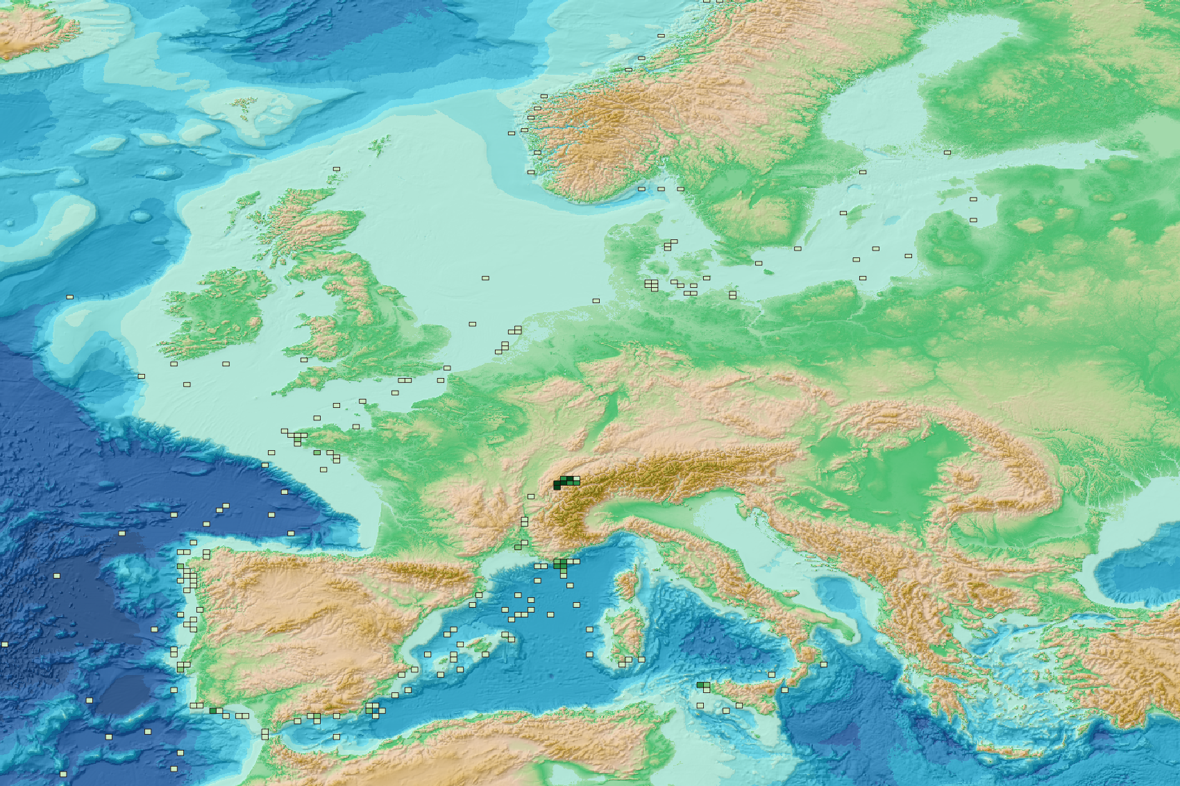
Micro litter - Spatial distribution of the sampling effort (period 2017-2022) - Other specific protocols v2025
This visualization product displays the spatial distribution of the sampling effort (based on the start position of the sampling tow) over the six-years' period 2017-2022 from other specific protocols.
EMODnet Chemistry included the collection of marine litter in its 3rd phase. Before 2021, there was no coordinated effort at the regional or European scale for micro-litter. Given this situation, EMODnet Chemistry proposed to adopt the data gathering and data management approach as generally applied for marine data, i.e., populating metadata and data in the CDI Data Discovery and Access service using dedicated SeaDataNet data transport formats. EMODnet Chemistry is currently the official EU collector of micro-litter data from Marine Strategy Framework Directive (MSFD) National Monitoring activities (descriptor 10).
A series of specific standard vocabularies or standard terms related to micro-litter have been added to SeaDataNet NVS (NERC Vocabulary Server) Common Vocabularies to describe the micro-litter.
European micro-litter data are collected by the National Oceanographic Data Centres (NODCs). Micro-litter map products are generated from NODCs data after a test of the aggregated collection including data and data format checks and data harmonization.
A filter is applied to represent only micro-litter samplings carried out according to a very specific protocol such as the Volvo Ocean Race (VOR) or Oceaneye.
The spatial distribution was then determined by calculating the number of times each cell was sampled during the period 2017-2022, only taking into account the start position of the tows. The corresponding total distance (kms) sampled in each cell is also provided in the attribute table.
Information on data processing and calculation are detailed in the attached methodology document.
Warning: the absence of data on the map does not necessarily mean that they do not exist, but that no information has been entered in the National Oceanographic Data Centre (NODC) for this area.
This work is based on the work presented in the following scientific article:
O. Gerigny, M. Brun, M.C. Fabri, C. Tomasino, M. Le Moigne, A. Jadaud, F. Galgani, Seafloor litter from the continental shelf and canyons in French Mediterranean Water: Distribution, typologies and trends, Marine Pollution Bulletin, Volume 146, 2019, Pages 653-666, ISSN 0025-326X, https://doi.org/10.1016/j.marpolbul.2019.07.030.
Simple
- Alternate title
-
mlf_spatialdistribution_samplingeffort_other_30km
- Date (Creation)
- 2025-02-07T00:00:00
- Edition
-
1.0
- Citation identifier
- DOI:10.13120/ff73051b-b193-4ec4-9c02-cb368487eb3e
- Credit
-
EMODnet Chemistry
Point of contact
-
Thèmes Sextant
-
-
/Human Activities/Pollution
-
- Theme
-
-
EMODnet Chemistry
-
- Ocean Hackathon - City and challenge
-
- /Boulogne-sur-Mer/BOL02
- /Boulogne-sur-Mer/BOL04
- /Boulogne-sur-Mer/BOL06
- /Bournemouth/BOR01
- /Kuala Lumpur/KUL08
- /Peniche/PEN01
- /Bournemouth
- /Cape Town
- /Concepción/CON06
- /Brest
- /Boulogne-sur-Mer
- /Cherbourg
- /La Rochelle/LAR01
- /Nouméa
- /Kuala Lumpur
- /International and global data portals
- /La Rochelle
- /Concepción
- /Plymouth
- /Nord de la Réunion
- /Rimouski
- /Peniche
- /Toulon
- Use limitation
-
CC BY 4.0: https://creativecommons.org/licenses/by/4.0/
- Access constraints
- unrestricted
- Use constraints
- Other restrictions
- Other constraints
-
Usage is subject to mandatory citation: "This resource was generated in the framework of EMODnet Chemistry, under the support of DG MARE Call for Tender EASME/EMFF/2020/3.1.11/European Marine Observation and Data Network (EMODnet) - Lot 5 - Chemistry".
- Spatial representation type
- Vector
- Language
-
eng
- Topic category
-
- Oceans
- Description
-
bounding box
))
- Begin date
- 2011-08-31
- End date
- 2021-06-15
Vertical extent
- Minimum value
- -20.0
- Maximum value
- 0.0
- Reference system identifier
- EPSG / WGS 84 (EPSG:4326)
- Geometric object type
- Point
- Distribution format
-
Name Version
- OnLine resource
-
Protocol Linkage Name WWW:LINK
https://doi.org/10.6092/d3e239ec-f790-4ee4-9bb4-c32ef39b426d Guidelines and formats for gathering micro-litter data
WWW:LINK
https://sextant.ifremer.fr/documentation/emodnet_chemistry/document/Field_description/MLF_field_description_location.xlsx Description of the layer's fields
WWW:DOWNLOAD
https://sextant.ifremer.fr/sextant_data/EMODNET/CHEMISTRY/MARINE_LITTER/2023/mlf_location_other.zip Direct Download
WWW:LINK
https://emodnet.ec.europa.eu/geoviewer/ EMODnet Map Viewer
OGC:WMS
https://sextant.ifremer.fr/services/wms/emodnet_chemistry2 mlf_location_other
WWW:LINK
https://doi.org/10.13120/skvs-yz64 Visualization products for floating micro-litter data
WWW:LINK
https://doi.org/10.1016/j.marpolbul.2019.07.030 Seafloor litter from the continental shelf and canyons in French Mediterranean Water: Distribution, typologies and trends
DOI
https://doi.org/10.13120/ff73051b-b193-4ec4-9c02-cb368487eb3e Digital Object Identifier (DOI)
- Hierarchy level
- Series
Conformance result
- Title
-
COMMISSION REGULATION (EU) No 1089/2010 of 23 November 2010 implementing Directive 2007/2/EC of the European Parliament and of the Council as regards interoperability of spatial data sets and services
- Date (Publication)
- 2010-12-08
- Explanation
-
See the referenced specification
- Statement
-
The original datasets can be searched and downloaded from EMODnet Chemistry Chemistry CDI Data and Discovery Access Service: https://cdi-chemistry.seadatanet.org/search
Metadata
- File identifier
- ff73051b-b193-4ec4-9c02-cb368487eb3e XML
- Metadata language
- English
- Character set
- UTF8
- Hierarchy level
- Series
- Hierarchy level name
-
Product record
- Date stamp
- 2025-05-07T13:23:22.963055Z
- Metadata standard name
-
ISO 19115:2003/19139 - EMODNET - SDN
- Metadata standard version
-
1.0
- Metadata author
-
Organisation name Individual name Electronic mail address Role EMODnet Chemistry
Point of contact
)))
