 EMODnet Product Catalogue
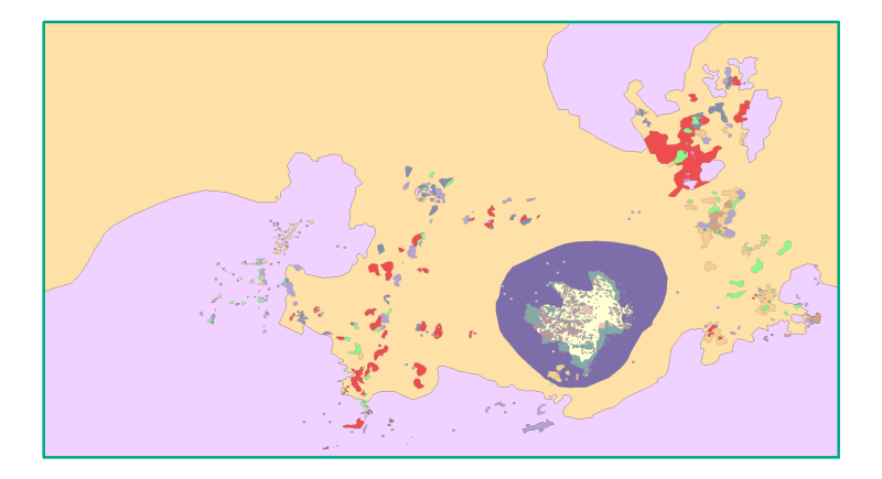
Habitats LIC Sur de Almería - Seco de los Olivos
This dataset contains the main habitats maps from the SCI (Site of Community Importance) ÔÇ£Sur de Almer├¡a - Seco de los OlivosÔÇØ. Seco de los Olivos is a seamount situated in the Alboran Sea (western Mediterranean, southeast Iberian peninsula). This study was supported by the INDEMARES-LIFE+ Project, EC contract INDEMARES-LIFE+ (07/NAT/E/000732): Inventory and Designation of Marine Natura 2000 Network areas in the Spanish seas (www.indemares.es/en). This work was coordinated by the Spanish Institute of Oceanography (IEO, www.ieo.es) and the Biodiversity Foundation (www.fundacion-biodiversidad.es). The interpretation has been made possible thanks to direct and indirect samplings and geophysical data from campaigns ÔÇ£OCEANA I-2010ÔÇØ, ÔÇ£OCEANA II-2011ÔÇØ, ÔÇ£OCEANA III-2012ÔÇØ and ÔÇ£INDEMARES_SECO1012ÔÇØ. Habitats are classified according to EUNIS nomenclature and the List of Marine Habitats in Spain (LPRE, that itÔÇÖs classified hierarchically and was completed and published in March 2013).
Identificatie
| Alternatieve titel | ES001023 |
|---|---|
| Versiedatum | 2015-10-05T00:00:00 |
| Type versiedatum | Wijziging: Datum van wijziging, controle, verbetering van dataset. |
Inhoud
| Doel van vervaardiging | Marine habitats research and seabed habitats distribution mapping for Marine Natura 2000 Network areas declaration. It was performed with geophysical data and direct and indirect samplings obtained in the Project INDEMARES South of Almería - Seco de los Olivos (LIFE+ 07/NAT/E/000732). The study area is situated in the Alboran Sea (western Mediterranean). We would like to thank the captains and all the crews of R/V Angeles Alvariño and R/V Ranger. |
|---|---|
| Status | compleet: Productie van de data is compleet / afgerond. |
Contactgegevens dataset(serie)
| Naam Contactpersoon | Fundaci├│n Biodiversidad |
|---|---|
| Organisatie | Fundaci├│n Biodiversidad (Biodiversity Fundation) |
| Adres | Calle Jos├® Abascal, 4, Planta 6 |
| Plaats | Madrid |
| Postcode | 28003 |
| Land | Spain |
| indemares@fundacion-biodiversidad.es | |
| Rol | Contactpunt: Partij waarmee contact kan worden opgenomen voor het vergaren van kennis of verstrekking van de data. |
Contactgegevens dataset(serie)
| Naam Contactpersoon | Instituto Español de Oceanografía (IEO) |
|---|---|
| Organisatie | Instituto Español de Oceanografía (Spanish Institute of Oceanography) (IEO) |
| Telefoon | +34 91 342 11 00 |
| Adres | Calle del Corazón de María, 8 |
| Plaats | Madrid |
| Postcode | 28002 |
| Land | Spain |
| ideo@ieo.es | |
| Rol | Eigenaar: Partij die eigenaar is van de data. |
Contactgegevens dataset(serie)
| Naam Contactpersoon | Alberto Serrano L├│pez |
|---|---|
| Organisatie | Instituto Español de Oceanografía (Spanish Institute of Oceanography) (IEO) |
| Land | Spain |
| aserrano@st.ieo.es | |
| Rol | Inwinner: Sleutelpartij verantwoordelijk voor verzamelen van data en de uitvoering van onderzoek. |
| Frequentie | Niet gepland: Er zijn geen plannen om de data te actualiseren. |
|---|---|
| Voorbeeldweergave dataset(serie) | https://gis.ices.dk/geonetwork/srv/api/records/3895c679-974d-4eeb-89d2-9e987ed35b01/attachments/Habitats_SECO_s.png |
| Voorbeeldweergave dataset(serie) | https://gis.ices.dk/geonetwork/srv/api/records/3895c679-974d-4eeb-89d2-9e987ed35b01/attachments/Habitats_SECO.png |
Trefwoorden
| GEMET - INSPIRE themes, version 1.0 | Habitats and biotopesHábitats y biotoposProtected sitesLugares protegidosSpecies distributionDistribución de las especiesRasgos oceanográficosHidrografíaGeologyGeologíaBiologyBiología |
|---|---|
| GDI-Vlaanderen Trefwoorden | Metadata GDI-Vl-conform |
| Overige trefwoorden |
Marine habitat mapping
|
| Ruimtelijk schema dataset(serie) | vector: Vector data wordt gebruikt om geografische data te representeren. |
|---|
Ruimtelijke resolutie dataset(serie)
| Noemer | 50000 |
|---|
| Karakterset | UTF-8: 8-bit variabele grootte universele karakterset, gebaseerd op ISO/IEC 10646 |
|---|---|
| Categorie(ën) |
Milieu |
Begrenzing
| Omschrijving geografische begrenzing | |
|---|---|
| Identificator geografische begrenzing |
Begrenzing
| Omschrijving geografische begrenzing | |||||||||
|---|---|---|---|---|---|---|---|---|---|
Omschrijvende rechthoek
|
|||||||||
| Identificator geografische begrenzing | |||||||||
Begrenzing
| Omschrijving geografische begrenzing | |
|---|---|
| Identificator geografische begrenzing |
Referentiesysteem
Horizontaal en/of verticaal referentiesysteem
| Unieke code | WGS 1984 |
|---|
Kwaliteit
| Niveau kwaliteitsinformatie | Dataset: Informatie heeft betrekking op de dataset. |
|---|
Bewerkingen
| Algemene beschrijving herkomst | Manual translation: Each EUNIS habitat within the map was manually determined and entered by an expert. | ||
|---|---|---|---|
Processtappen
|
|||
Toegangs- en gebruiksbeperkingen
Legale en veiligheidsbeperkingen
Beperkingen van de dataset(serie)
|
|||||||||||||
Distributie
| Distributieformaat | Shapefile (Version: ESRI ArcGIS 10.1) | ||||||||||||||||||||||||||||
|---|---|---|---|---|---|---|---|---|---|---|---|---|---|---|---|---|---|---|---|---|---|---|---|---|---|---|---|---|---|
Overdracht
|
|||||||||||||||||||||||||||||
Meta-metadata
| Metadata identificator (fileIdentifier) | 3895c679-974d-4eeb-89d2-9e987ed35b01 | ||||||||||||||||||||||||||||
|---|---|---|---|---|---|---|---|---|---|---|---|---|---|---|---|---|---|---|---|---|---|---|---|---|---|---|---|---|---|
| Karakterset metadatarecord | UTF-8: 8-bit variabele grootte universele karakterset, gebaseerd op ISO/IEC 10646 | ||||||||||||||||||||||||||||
| Metadata wijzigingsdatum | 2020-01-15T12:20:16 | ||||||||||||||||||||||||||||
| Naam metadatastandaard | ISO 19115:2003/19139 | ||||||||||||||||||||||||||||
| Versie metadatastandaard | 1.0 | ||||||||||||||||||||||||||||
Metadata-auteur
|
|||||||||||||||||||||||||||||
Overviews

thumbnail
large_thumbnail