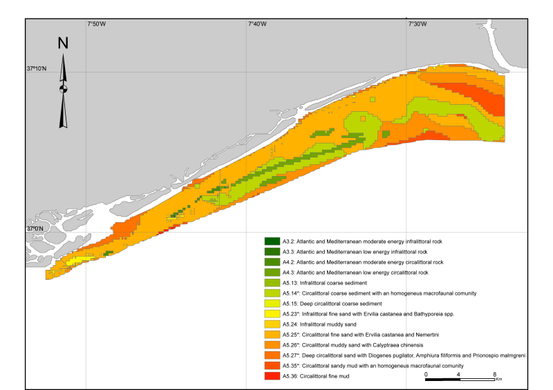
Habitat map of Algarve continental shelf between Olhão and V.R.S. António
Map based on available information of marine charts and two surveys. Preliminary map preparation involved scanning, georeferencing and digitizing of pre-existing base map from the Portuguese Hydrographic Institute and harmonization with other published and non-published cartographic information. Samples of soft bottom shelf sediments from nearly 100 sites, collected in the scope of the ACOSHELF project, were analyzed for grain-size, total organic matter and macrofaunal comunities.
owner : {{md.getOwnername()}}
{{'mdStatusRecord' | translate}}: {{('mdStatus-' + md.mdStatus) | translate}}
- Identification
- Content
- ReferenceSystem
- Quality
- DomainConsistancy
- Constraints
- Distribution
- Meta-metadata
- ObjectCatalogue
| Alternate title | PT001007 |
|---|---|
| Date | 2011-05-20T00:00:00 |
| Date type | Creation: Date identifies when the resource was brought into existence |
| Purpose | Research |
|---|---|
| Status | On going: Data is continually being updated |
Point of contact
| Individual name | Ant├│nio Silva & Rosa Freitas |
|---|---|
| Organisation name | University of Aveiro |
| Voice | (+351) 234 370 350 (ext 22739) |
| Delivery point | University of Aveiro |
| Delivery point | Campus Universitário de Santiago |
| City | Aveiro |
| Postal code | 3810-193 Aveiro |
| Country | Portugal |
| Electronic mail address | antoniojsilva@ua.pt |
| Electronic mail address | rosafreitas@ua.pt |
| Role | Author: Party who authored the resource |
| Maintenance and update frequency | As needed: Data is updated as deemed necessary |
|---|
Descriptive keywords
| GEMET - INSPIRE themes, version 1.0 | |
|---|---|
| GDI-Vlaanderen Trefwoorden | Metadata GDI-Vl-conform |
| Other keywords | Portuguese continental shelf |
| Other keywords | Marine habitat mapping |
| Spatial representation type | Vector: Vector data is used to represent geographic data |
|---|
Spatial resolution
| Denominator | 50000 |
|---|
| Character set | UTF8: 8-bit variable size UCS Transfer Format, based on ISO/IEC 10646 |
|---|---|
| Topic category code |
|
| Supplemental Information | The sedimentary classification system used was the FOLK-MESH ATLANTIC used in the MeshAtlantic project. |
Reference System Information
| Unique resource identifier | WGS 1984 |
|---|
| Hierarchy level | Dataset: Information applies to the dataset |
|---|
mdLegalAndSecurityConstraintsSection
Resource constraints
|
|||||
| Distribution format | Shapefile (Version: ESRI ArcGIS) | ||||||||||||||||||||||||||||||||
|---|---|---|---|---|---|---|---|---|---|---|---|---|---|---|---|---|---|---|---|---|---|---|---|---|---|---|---|---|---|---|---|---|---|
Transfer options
|
|||||||||||||||||||||||||||||||||
| File identifier | 405e3448-d86e-407b-aa3d-9ebfa04af96d | ||||||||||||||||||
|---|---|---|---|---|---|---|---|---|---|---|---|---|---|---|---|---|---|---|---|
| Character set | UTF8: 8-bit variable size UCS Transfer Format, based on ISO/IEC 10646 | ||||||||||||||||||
| Date stamp | 2020-01-23T10:28:59 | ||||||||||||||||||
| Metadata standard name | ISO 19115:2003/19139 | ||||||||||||||||||
| Metadata standard version | 1.0 | ||||||||||||||||||
Contact
|
|||||||||||||||||||
Overviews

EUNIS_alg_s.png

EUNIS_alg.png
extent
- geoDesc
- {{d}}
- geoBox
-
- geoDescCode
- {{mdView.current.record.geoDescCode}}
tempExtent
- creationDate
- publicationDate
- revisionDate
- tempExtentBegin
Associated resources
Not available
 EMODnet Product Catalogue
}})