 EMODnet Product Catalogue
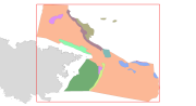
Habitats LIC Sistema de Ca├▒ones Submarinos Occidentales del Golfo de Le├│n
This dataset contains the habitats map from the SCI (Site of Community Importance) ÔÇ£Sistema de Ca├▒ones Submarinos Occidentales del Golfo de Le├│nÔÇØ. The marine area ÔÇ£South-West Gulf of Lions canyons systemÔÇØ is located in the northeastern part of the Iberian Peninsula. The coastline belongs to the Catalan province of Girona, featuring a large number of rocky outcrops with many coves, small beaches, vertical cliffs and islets. Cape Creus is the most notorious element of the landscape, which corresponds to the easternmost part of the Pyrenees Mountains. This small peninsula is characterized by its wildness, and despite its low relief it penetrates into the Mediterranean Sea for more than 10 kilometers.This study was supported by the INDEMARES-LIFE+ Project, EC contract INDEMARES-LIFE+ (07/NAT/E/000732): Inventory and Designation of the Natura 2000 network in marine areas of the Spanish State (www.indemares.es/en). This work was coordinated by the Biodiversity Foundation (www.fundacion-biodiversidad.es). Habitats are classified according to EUNIS nomenclature and the List of Marine Habitats in Spain (LPRE, that itÔÇÖs classified hierarchically and was completed and published in March 2013). Habitats classification are been simplified owing to the requirements of the EMODnet (European Marine Observation and Data Network) portal for Seabed Habitats.
Identificatie
| Alternatieve titel | ES001026 |
|---|---|
| Versiedatum | 2015-10-05T00:00:00 |
| Type versiedatum | Wijziging: Datum van wijziging, controle, verbetering van dataset. |
Inhoud
| Doel van vervaardiging | Marine habitats research and seabed habitats distribution mapping for Marine Natura 2000 Network areas declaration. It was performed with geophysical data and direct and indirect samplings obtained in the Project INDEMARES Sistema de Ca├▒ones Submarinos Occidentales del Golfo de Le├│n (South-West Gulf of Lions canyons system) (LIFE+ 07/NAT/E/000732). The study area is situated in the northeastern part of the Iberian Peninsula (Mediterranean Sea). |
|---|---|
| Status | compleet: Productie van de data is compleet / afgerond. |
Contactgegevens dataset(serie)
| Naam Contactpersoon | Fundaci├│n Biodiversidad |
|---|---|
| Organisatie | Fundaci├│n Biodiversidad (Biodiversity Fundation) |
| Adres | Calle Jos├® Abascal, 4, Planta 6 |
| Plaats | Madrid |
| Postcode | 28003 |
| Land | Spain |
| indemares@fundacion-biodiversidad.es | |
| Rol | Contactpunt: Partij waarmee contact kan worden opgenomen voor het vergaren van kennis of verstrekking van de data. |
Contactgegevens dataset(serie)
| Naam Contactpersoon | Institut de Ciències del Mar |
|---|---|
| Organisatie | Institute of Marine Sciences in Barcelona - CSIC (Spanish National Research Council) |
| Telefoon | +34932309500 |
| Adres | Passeig Marítim de la Barceloneta, 37-49 |
| Plaats | Barcelona |
| Postcode | 08003 |
| Land | Spain |
| secredir@icm.csic.es | |
| Rol | Eigenaar: Partij die eigenaar is van de data. |
Contactgegevens dataset(serie)
| Naam Contactpersoon | Josep-Maria Gili |
|---|---|
| Organisatie | Institut de Ciències del Mar - CSIC |
| Telefoon | +34932309546 |
| Adres | Passeig Marítim de la Barceloneta, 37-49 |
| Plaats | Barcelona |
| Postcode | 08003 |
| Land | Spain |
| gili@icm.csic.es | |
| Rol | Inwinner: Sleutelpartij verantwoordelijk voor verzamelen van data en de uitvoering van onderzoek. |
Contactgegevens dataset(serie)
| Naam Contactpersoon | Alberto Serrano L├│pez |
|---|---|
| Organisatie | INSTITUTO ESPAÑOL DE OCEANOGRAFÍA (Spanish Institute of Oceanography) (IEO) |
| Telefoon | +34942291716 |
| Adres | Promontorio San Martín s/n |
| Plaats | Santander |
| Postcode | 39004 |
| Land | Spain |
| aserrano@st.ieo.es | |
| Rol | Inwinner: Sleutelpartij verantwoordelijk voor verzamelen van data en de uitvoering van onderzoek. |
| Frequentie | Indien nodig: Data wordt geactualiseerd indien nodig. |
|---|---|
| Voorbeeldweergave dataset(serie) | https://gis.ices.dk/geonetwork/srv/api/records/8304512f-94cf-4174-a4d5-fef00b05b1c0/attachments/Habitats_GolfodeLeon_s.png |
Trefwoorden
| GEMET - INSPIRE themes, version 1.0 | Habitats and biotopes, Hábitats y biotopos, Protected sites, Lugares protegidos, Species distribution, Distribución de las especies, Rasgos oceanográficos, Hidrografía, Geology, Geología, Biology, Biología |
|---|---|
| GDI-Vlaanderen Trefwoorden | Metadata GDI-Vl-conform |
| Overige trefwoorden | Marine habitat mapping, INDEMARES, LIFE, LIFE+, Institut of Marine Sciences, ICM, CSIC, Instituto Español de Oceanografía, FUNDACIÓN BIODIVERSIDAD, EMODNET, EUSeaMap, Mediterranean Sea, Golfo de León, Gulf of Lions, Cape Creus, Benthos, Bentos, Habitat, Hábitat, Seabed, Fondo marino |
| Ruimtelijk schema dataset(serie) | vector: Vector data wordt gebruikt om geografische data te representeren. |
|---|
Ruimtelijke resolutie dataset(serie)
| Noemer | 95000 |
|---|
| Karakterset | UTF-8: 8-bit variabele grootte universele karakterset, gebaseerd op ISO/IEC 10646 |
|---|---|
| Categorie(ën) |
Milieu |
Begrenzing
| Omschrijving geografische begrenzing | |
|---|---|
| Identificator geografische begrenzing |
Begrenzing
| Omschrijving geografische begrenzing | |||||||||
|---|---|---|---|---|---|---|---|---|---|
Omschrijvende rechthoek
|
|||||||||
| Identificator geografische begrenzing | |||||||||
Begrenzing
| Omschrijving geografische begrenzing | |
|---|---|
| Identificator geografische begrenzing |
Referentiesysteem
Horizontaal en/of verticaal referentiesysteem
| Unieke code | WGS 1984 |
|---|
Kwaliteit
| Niveau kwaliteitsinformatie | Dataset: Informatie heeft betrekking op de dataset. |
|---|
Bewerkingen
| Algemene beschrijving herkomst | EMODNET |
|---|
Toegangs- en gebruiksbeperkingen
Legale en veiligheidsbeperkingen
Beperkingen van de dataset(serie)
|
|||||||||||||
Distributie
| Distributieformaat | Shapefile (Version: ESRI ArcGIS 10.1) | ||||||||||||||||||||||||||||||||||
|---|---|---|---|---|---|---|---|---|---|---|---|---|---|---|---|---|---|---|---|---|---|---|---|---|---|---|---|---|---|---|---|---|---|---|---|
Overdracht
|
|||||||||||||||||||||||||||||||||||
Meta-metadata
| Metadata identificator (fileIdentifier) | 8304512f-94cf-4174-a4d5-fef00b05b1c0 | ||||||||||||||||||||||||||||||||
|---|---|---|---|---|---|---|---|---|---|---|---|---|---|---|---|---|---|---|---|---|---|---|---|---|---|---|---|---|---|---|---|---|---|
| Karakterset metadatarecord | UTF-8: 8-bit variabele grootte universele karakterset, gebaseerd op ISO/IEC 10646 | ||||||||||||||||||||||||||||||||
| Metadata wijzigingsdatum | 2020-01-23T11:20:25 | ||||||||||||||||||||||||||||||||
| Naam metadatastandaard | ISO 19115:2003/19139 | ||||||||||||||||||||||||||||||||
| Versie metadatastandaard | 1.0 | ||||||||||||||||||||||||||||||||
Metadata-auteur
|
|||||||||||||||||||||||||||||||||
Overviews
Habitats_GolfodeLeon_s.png