 EMODnet Product Catalogue
1338_SOUTH CALABRIA 2
Systematic survey performed by Italian Navy Hydrpgraphic vessels with Multibeam EchoSounder
owner : {{md.getOwnername()}}
{{'mdStatusRecord' | translate}}: {{('mdStatus-' + md.mdStatus) | translate}}
- Identification
- Content
- ReferenceSystem
- Quality
- DomainConsistancy
- Constraints
- Distribution
- Meta-metadata
- ObjectCatalogue
| Date | 2018-10-25T00:00:00 |
|---|---|
| Date type | Creation: Date identifies when the resource was brought into existence |
| Date | 2018-10-25T00:00:00 |
| Date type | Revision: Date identifies when the resource was examined or re-examined and improved or amended |
| Unique resource identifier | SOUTH_CALABRIA_2 |
Point of contact
| Organisation name | Italian Navy Hydrographic Office |
|---|---|
| Voice | +39 010 24431 |
| Delivery point | Passo Osservatorio, 4 |
| City | Genova |
| Postal code | 16134 |
| Country | Italy |
| Electronic mail address | iim.sre@marina.difesa.it |
| Linkage | http://www.marina.difesa.it |
| Role | Originator: Party who created the resource |
Point of contact
| Organisation name | Italian Navy Hydrographic Office |
|---|---|
| Voice | +39 010 24431 |
| Delivery point | Passo Osservatorio, 4 |
| City | Genova |
| Postal code | 16134 |
| Country | Italy |
| Electronic mail address | iim.sre@marina.difesa.it |
| Linkage | http://www.marina.difesa.it |
| Role | Custodian: Party that accepts accountability and responsability for the data and ensures appropriate care and maintenance of the resource |
Descriptive keywords
| Spatial representation type | Grid: Grid data is used to represent geographic data |
|---|
Spatial resolution
| Denominator | 100000 |
|---|
Spatial resolution
| Distance | 0.03125 Arc minute |
|---|
| Language | English |
|---|---|
| Character set | UTF8: 8-bit variable size UCS Transfer Format, based on ISO/IEC 10646 |
| Topic category code |
|
Reference System Information
| Unique resource identifier | WGS 84 (EPSG:4326) |
|---|---|
| Codespace | EPSG |
| Hierarchy level | Dataset: Information applies to the dataset |
|---|---|
| Hierarchy level | Software: Information applies to a computer program or routine |
| Hierarchy level | Property type: Information applies to a property type |
| Other | software |
Absolute external positional accuracy
Quantitative result
|
|||
Absolute external positional accuracy
Quantitative result
|
|||
Lineage
| Statement | EMODnet processing methodology using Globe software |
|---|
mdLegalAndSecurityConstraintsSection
Resource constraints
|
|||||||||||
Distributor
|
|||||||||||||||||||||||||
Transfer options
|
|||||||||||||||||||||||||
| File identifier | SDN_CPRD_1338_SOUTH_CALABRIA_2 | ||||||||||||||||||
|---|---|---|---|---|---|---|---|---|---|---|---|---|---|---|---|---|---|---|---|
| Metadata language | English | ||||||||||||||||||
| Character set | UTF8: 8-bit variable size UCS Transfer Format, based on ISO/IEC 10646 | ||||||||||||||||||
| Hierarchy level name | Composite Product Record | ||||||||||||||||||
| Date stamp | 2025-03-07T14:09:41.007958Z | ||||||||||||||||||
| Metadata standard name | ISO 19115:2003/19139 - EMODNET - BATHYMETRY | ||||||||||||||||||
| Metadata standard version | 1.0 | ||||||||||||||||||
Contact
|
|||||||||||||||||||
Overviews
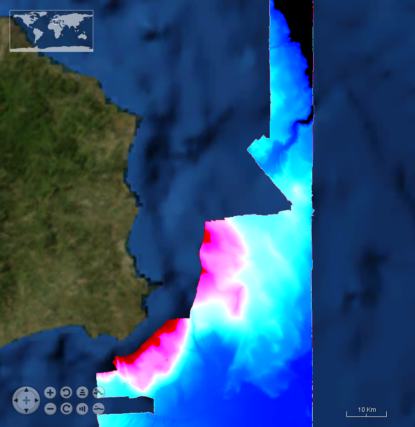
SOUTH%20CALABRIA%2022.png
extent
- geoDesc
- {{d}}
- geoBox
-
}})
- geoDescCode
- {{mdView.current.record.geoDescCode}}
tempExtent
- creationDate
- publicationDate
- revisionDate
- tempExtentBegin
Associated resources
Not available