280_201203-HRDTM-Atlantic_Gulf of Cadiz-60m
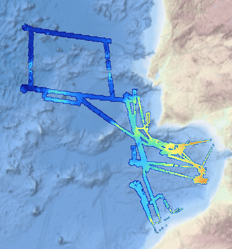
This composite Digital Terrain Model (cDTM) is a high resolution bathymetry dataset that covers bathymetry surveys INSIGHT_LEG1, FRAME-OBS, FRAME-MCS and INSIGHT_LEG2 . Multibeam data acquired in 2018 and 2019 on board the R/V Sarmiento de Gamboa using an Atlas Hydrosweep DS-3 multi-beam echosounder.
Identificatie
| Alternatieve titel |
KN172L08 SeaBeam 3012-P1 Bathymetry Grid |
| Versiedatum |
2020-12-02T00:00:00
|
| Type versiedatum |
Creatie: Aanmaakdatum of opnamedatum van de dataset. |
| Versiedatum |
Invalid DateT00:00:00
|
| Type versiedatum |
Wijziging: Datum van wijziging, controle, verbetering van dataset. |
| Dataset identificator |
201203-Atlantic_Gulf of Cadiz |
Inhoud
| Organisatie |
ICM-CSIC/ Institute of Marine Sciences |
| Telefoon |
+34 932 309500 |
| Adres |
Paseo Marítimo de la Barceloneta, 37-49 |
| Plaats |
Barcelona |
| Postcode |
08003 |
| Land |
Spain |
| E-mail |
secredir@icm.csic.es
|
| Connectiepunt URL |
http://www.icm.csic.es
|
| Rol |
Producent: Partij die de data heeft aangemaakt. |
| Organisatie |
ICM-CSIC/ Institute of Marine Sciences |
| Telefoon |
+34 932 309500 |
| Adres |
Paseo Marítimo de la Barceloneta, 37-49 |
| Plaats |
Barcelona |
| Postcode |
08003 |
| Land |
Spain |
| E-mail |
secredir@icm.csic.es
|
| Connectiepunt URL |
http://www.icm.csic.es
|
| Rol |
Beheerder: Partij die verantwoordelijkheid heeft geaccepteerd en zorg draagt voor het beheer
van de data. |
| Project name |
EMODNet Bathymetry
|
| SeaDataNet device categories |
multi-beam echosounders
,
multi-beam echosounders
|
| SeaDataNet device categories |
Differential Global Positioning System receivers
|
| Parameter Discovery Vocabulary (P02) |
Bathymetry and Elevation
|
| GEMET - INSPIRE themes, version 1.0 |
Hydrography |
| GDI-Vlaanderen Trefwoorden |
Metadata GDI-Vl-conform
|
| Ruimtelijk schema dataset(serie) |
grid: Grid data wordt gebruikt om geografische
data te representeren. |
| Grondresolutie |
0.03125 Arc minute |
| Taal |
Engels |
| Karakterset |
UTF-8: 8-bit variabele grootte universele karakterset, gebaseerd op ISO/IEC 10646 |
| Categorie(ën) |
Oceanen
|
| Omschrijving geografische begrenzing |
|
| Identificator geografische begrenzing |
|
| Omschrijving geografische begrenzing |
|
| Minimum x-coordinaat |
-15.50 |
| Maximum x-coordinaat |
-6.20 |
| Minimum y-coordinaat |
33.00 |
| Maximum y-coordinaat |
40.4516 |
|
| Identificator geografische begrenzing |
|
| Omschrijving geografische begrenzing |
Map projection parameters, values and units :
Axes units :
UPPER LEFT X=29.3054583250
UPPER LEFT Y=44.6262830219
LOWER RIGHT X=40.7816282263
LOWER RIGHT Y=41.2281769950
WEST LONGITUDE=29° 18' 19.6500" E
NORTH LATITUDE=44° 37' 34.6189" N
EAST LONGITUDE=40° 46' 53.8616" E
SOUTH LATITUDE=41° 13' 41.4372" N
PROJ_DESC=Geographic (Latitude/Longitude) / WGS84 / arc degrees
PROJ_DATUM=WGS84
PROJ_UNITS=arc degrees
EPSG_CODE=4326
COVERED AREA=353215 sq km |
| Identificator geografische begrenzing |
|
Referentiesysteem
| Unieke code |
WGS 84 (EPSG:4326) |
| Codespace |
EPSG |
Kwaliteit
| Niveau kwaliteitsinformatie |
Dataset: Informatie heeft betrekking op de dataset. |
| Niveau kwaliteitsinformatie |
Object: Informatie heeft betrekking op een object. |
| Niveau kwaliteitsinformatie |
Software: Informatie heeft betrekking op een computerprogramma of code. |
| Niveau kwaliteitsinformatie |
Kenmerktype: Informatie heeft betrekking op een kenmerktype. |
| Niveau kwaliteitsinformatie |
Dataset: Informatie heeft betrekking op de dataset. |
| Beschrijving niveau kwaliteitsinformatie |
software |
| Waarde |
2 - MBES low frequency (lower than 100kHz) (similar than 1+2%d) |
|
| Algemene beschrijving herkomst |
no information |
| Algemene beschrijving herkomst |
EMODnet processing methodology using Globe software |
Toegangs- en gebruiksbeperkingen
| (Juridische) toegangsbeperking |
Creative Commons Attribution 4.0 International: Creative Commons Attribution 4.0 International |
| (Juridische) gebruiksbeperking |
anders: Restrictie niet opgenomen in lijst. |
| Overige beperkingen |
DO NOT USE FOR NAVIGATION |
|
|
|
Distributie
| Distributieformaat |
NetCDF
|
| Organisatie |
UTM-CSIC/Marine Technology Unit |
| Telefoon |
+34 932 309500 |
| Adres |
Paseo Maritimo de la Barceloneta, 37-49 |
| Plaats |
Barcelona |
| Postcode |
08003 |
| Land |
Spain |
| E-mail |
data@utm.csic.es
|
| Connectiepunt URL |
http://www.utm.csic.es/
|
| Rol |
Verdeler: Partij die de data verstrekt. |
|
|
|
Meta-metadata
 EMODnet Product Catalogue