Algarve:Mapping of marine biocenoses off the National Underwater Ecological Reserve between rio Arade and Ponta Piedade - CCMAR-CCDRALG
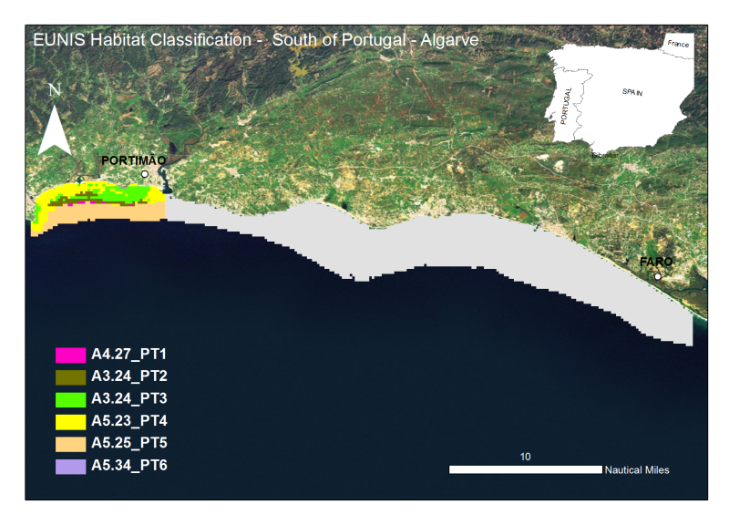
The Algarve coast presents a significant portion of territory that is part of the designated National Nature Reserve, in its underwater slope (0 to 30m depth - RENSUB), especially when compared with the equivalent on land. The current digital map presents the EUNIS habitat of the central Algarve RENSUB coast. The covered area is between Rio Arade and Ponta da Piedade. The sediment classification was obtained through the interpretation of data from Side Scan Sonar (remote-sensing image), while for the habitat mapping the biological sampling was carried out with beam trawl and underwater visual census.
owner
: {{md.getOwnername()}}
{{'mdStatusRecord' | translate}}: {{('mdStatus-' + md.mdStatus) | translate}}
| Alternate title |
PT000004 |
| Date |
2010-12-01T00:00:00
|
| Date type |
Revision:
Date identifies when the resource was examined or re-examined and improved or
amended
|
| Edition |
2012 |
| Purpose |
Provide information on the EUNIS Habitat |
| Status |
Historical archive:
Data has been stored in an offline storage facility
|
| Individual name |
Pedro Monteiro & Jorge Gonçalves |
| Organisation name |
University of Algarve (UAlg-FCT)- Centre of Marine Sciences (CCMAR) |
| Voice |
+351 289 800069 (ext7367) |
| Delivery point |
Universidade do Algarve (CCMAR-FCT) |
| Delivery point |
Campus de Gambelas |
| Delivery point |
Edificio 7 |
| City |
Faro |
| Postal code |
8005-139 Faro |
| Country |
Portugal |
| Electronic mail address |
jgoncal@ualg.pt
|
| Electronic mail address |
pmontei@ualg.pt
|
| Role |
Author:
Party who authored the resource
|
| Individual name |
Sebastião Teixeira |
| Organisation name |
Regional Hydrological Administration of the Algarve (ARH Algarve) |
| Voice |
+351289 889000 |
| Delivery point |
Administration of the Algarve (ARH Algarve)entral |
| Delivery point |
Rua do Alportel |
| Delivery point |
n┬║ 10 ÔÇô R/C |
| City |
Faro |
| Postal code |
8000-503 Faro |
| Country |
Portugal |
| Electronic mail address |
presidencia@arhalgarve.pt
|
| Role |
Point of contact:
Party who can be contacted for acquiring knowledge about or acquisition of the
resource
|
| Maintenance and update frequency |
Not planned:
There are no plans to update the data
|
| GDI-Vlaanderen Trefwoorden |
Metadata GDI-Vl-conform
|
| Other keywords |
Habitat, Biocenosis, Biotope, EUNIS
|
| Other keywords |
Algarve, south Portugal, Faro, Albufeira, Portimão, Lagos
|
| Other keywords |
Habitat Map
|
| Spatial representation type |
Vector:
Vector data is used to represent geographic data
|
| Character set |
UTF8:
8-bit variable size UCS Transfer Format, based on ISO/IEC 10646
|
| Topic category code |
|
| Unique resource identifier |
WGS 1984 |
| Hierarchy level |
Dataset:
Information applies to the dataset
|
| Use limitation |
The access and use is possible with request to the Regional Hydrological Administration of the Algarve (ARH Algarve) and Centre of Marine Sciences (CCMAR) of the University of Algarve (UAlg/FTC) and nstituto Español de Oceanografía (IEO) |
| Access constraints |
License:
Formal permission to do something
|
| Use constraints |
License:
Formal permission to do something
|
|
|


 EMODnet Product Catalogue
}})