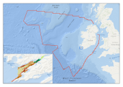
Multibeam echosounder data and seabed sampling data acquired during the 2011 MESH Atlantic survey were the primary sources of data used in the generation of this marine habitat map. Data on kinetic energy, derived from oceanographic models, and all of the interpreted survey data, were combined in a GIS environment and used to generate a EUNIS level 5 habitat map using the Maximum Likelihood Classification tool in ArcMap.
UTF8:
8-bit variable size UCS Transfer Format, based on ISO/IEC 10646
Topic category code
Supplemental Information
Polygon shapefile.
Reference System Information
Unique resource identifier
4326
Codespace
urn:ogc:def:crs:EPSG
Hierarchy level
Dataset:
Information applies to the dataset
Lineage
Statement
Multibeam echosounder data (MBES) were collected for the MESH Atlantic survey as part of the INFOMAR national seabed mapping project. The MBES data were classified into sediment classes using information from sediment samples. These sediment classes were classified into EUNIS level 5 habitat classes using biological sample data that had been grouped into similar classes using PRIMER. Kinetic energy data derived from oceanographic models in the bay were also incorporated into the final classification. Rock outcrops were digitised from shaded relief imagery and classified to EUNIS level 5 using video footage taken along transects of the rock outcrops.
Domain consistency
Conformance result
Specification
Title
INSPIRE Data Specification on Habitats and biotopes
Date
2011-06-15
Date type
Publication:
Date identifies when the resource was issued
Explanation
The INSPIRE Directive or INSPIRE lays down a general framework for a Spatial Data Infrastructure (SDI) for the purposes of European Community environmental policies and policies or activities which may have an impact on the environment.
 EMODnet Product Catalogue
}})