 EMODnet Product Catalogue
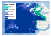
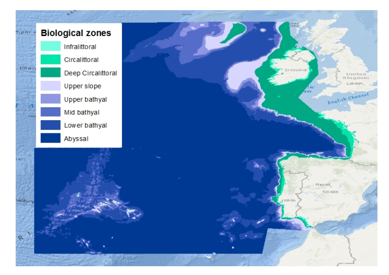
biological zones of the EU's Atlantic Area
This layer is a model of the biological zones of the EU's 'Atlantic Area 2007-2013'. It was performed within the framework of MeshAtlantic project (INTERREG ÔÇÿAtlantic Area 2007-2013ÔÇÖ program).
This layer was modelled with the use of bespoke base layers that were the bathymetry, wave wavelength and the kdpar
The biological zones boundaries were defined in the following way.
- Infralittoral lower limit: limit at which the percentage of light reaching the seabed is 1%. The percentage of light layer was calculated by intersecting the kdpar and the bathymetry layers. For more details about this calculation see e.g. Vasquez et al. (in press).
- Circalittoral lower limit: limit at which the ratio wave wave length over the depth equals 2.53
- Deep circalittoral lower limit: break of slope due to the entrance into the continental slope. This limit was digitalized with the use of the bathymetry layer
- Upper slope lower limit: depth 750m
- Upper bathyal lower limit: depth 1100m
- Mid bathyal lower limit: depth 1800m
- Lower bathyal lower limit: break of slope due to the entrance into the abyssal plain. This limit was digitalized with the use of the bathymetry layer
Deep biological zones (from upper slope to abyssal) were chosen according to the classification proposed by Howell (2010).
For more detail see Vasquez et al. (in press)
Howell, K.L., 2010. A benthic classification system to aid in the implementation of marine protected area networks in the deep/high seas of the NE Atlantic. Biological Conservation 143, 1041ÔÇô1056.
Vasquez, M., Mata Chac├│n, D., Tempera, F., OÔÇÖKeeffe, E., Galparsoro, I., Sanz Alonso, J. L., Gon├ºalves, J.M.S., Bentes, L., Amorim, P., Henriques, V., McGrath, F., Monteiro, P., Mendes, B., Freitas, R., Martins, R., Populus, J., In press. Broad-scale mapping of seafloor habitats in the north-east Atlantic using existing environmental data.
owner : {{md.getOwnername()}}
{{'mdStatusRecord' | translate}}: {{('mdStatus-' + md.mdStatus) | translate}}
- Identification
- Content
- ReferenceSystem
- Quality
- DomainConsistancy
- Constraints
- Distribution
- Meta-metadata
- ObjectCatalogue
| Date | 2014-01-01T00:00:00 |
|---|---|
| Date type | Publication: Date identifies when the resource was issued |
| Edition | v1 |
| Purpose | Marine spatial planning Marine protected areas design |
|---|---|
| Status | Completed: Production of the data has been completed |
Point of contact
| Individual name | Mickaël VASQUEZ |
|---|---|
| Organisation name | Ifremer |
| Electronic mail address | mickael.vasquez@ifremer.fr |
| Role | Point of contact: Party who can be contacted for acquiring knowledge about or acquisition of the resource |
| Maintenance and update frequency | As needed: Data is updated as deemed necessary |
|---|
Descriptive keywords
| GEMET - INSPIRE themes, version 1.0 | |
|---|---|
| GDI-Vlaanderen Trefwoorden | Metadata GDI-Vl-conform |
| Other keywords |
biological zones
|
EUNIS
|
infralittoral
|
circalittoral
|
upper slope
|
upper bathyal
|
mid bathyal
|
lower bathyal
|
Abyssal
|
Atlantic
|
MeshAtlantic
|
| Other keywords | Marine habitat mapping |
| Spatial representation type | Vector: Vector data is used to represent geographic data |
|---|
Spatial resolution
| Denominator | 1000000 |
|---|
| Character set | UTF8: 8-bit variable size UCS Transfer Format, based on ISO/IEC 10646 |
|---|---|
| Topic category code |
|
Reference System Information
| Unique resource identifier | WGS 1984 |
|---|
mdLegalAndSecurityConstraintsSection
Resource constraints
|
|||||||||
| Distribution format | Shapefile (Version: unknown) | ||||||||||||||||
|---|---|---|---|---|---|---|---|---|---|---|---|---|---|---|---|---|---|
Transfer options
|
|||||||||||||||||
| File identifier | 3f6f3998-91b7-4407-8b22-86885b9bbcfc | ||||||||
|---|---|---|---|---|---|---|---|---|---|
| Character set | UTF8: 8-bit variable size UCS Transfer Format, based on ISO/IEC 10646 | ||||||||
| Date stamp | 2020-01-23T11:30:42 | ||||||||
| Metadata standard name | ISO 19115:2003/19139 | ||||||||
| Metadata standard version | 1.0 | ||||||||
Contact
|
|||||||||
Overviews
atlatntic_s.png
atlatntic.png
extent
- geoDesc
- {{d}}
- geoBox
-
}})
- geoDescCode
- {{mdView.current.record.geoDescCode}}
tempExtent
- creationDate
- publicationDate
- revisionDate
- tempExtentBegin
Associated resources
Not available